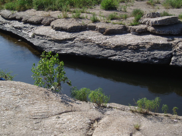
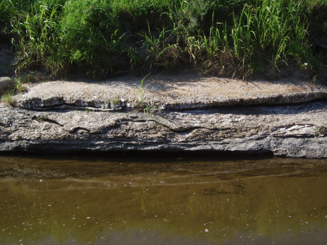
Gypsum Creek in southeast Wichita, Kansas, offers some of the most beautiful sites in the city. This earthcache brings you to a mineral site where gypsum can be found all around in many forms. Gypsum Creek flows through many areas that have been developed into city parks. This site is open to the public and has a paved bike path that follows the creek at the high bank. The Wichita Parks and Recreation Department is proud of the Gypsum Creek Bike Path which is used for cycling, jogging and walking. Step cautiously when you are near the water. Look to the other bank to get an idea of what is under your own feet. Near the water's edge, the ledges are flat and wide enough that they act like sidewalks, providing you with the opportunity to peruse the surroundings by the bottom of the creek.
GYPSUM CREEK GEOLOGY
(source)
-
Coming from the Rocky Mountains
Gypsum Creek, located in today's Wichita, Kansas, is a tributary to the Arkansas River and helps drain the eastern part of the city. The Arkansas River Lowlands is made up of rocks deposited by the Arkansas River during the last 10 million years (no later than the Miocene Epoch) as the river meandered through Kansas from its origin high in the Rocky Mountains. In the Rockies, the hydraulic cycle fed the Arkansas River with storm water runoff, snowmelt, and eroded rock debris that weathered from the mountains. However, as the Arkansas River moved out here onto the High Plains, it received little additional water, and even lost water to its sandy riverbed. As its flow decreased, the river's ability to carry sediments also diminished and it began to drop its sediment load. The Arkansas River changed from a degrading stream (one that cuts downward in its channel) to an aggrading stream (one that builds up the riverbed). Continuing with this process over time, sedimentary minerals formed evaporite deposits over the Arkansas River Lowlands. The process continues today.
-
Sedimentary Rocks
Sedimentary rocks, of which we find gypsum, are formed from sediment, broken rocks and organic matter. Many sedimentary rocks are formed when wind or water deposits sediment into layers, which are pressed together by more layers of sediment, forming underground beds of rocks. Sedimentary rocks fall into three categories: clastic, biogenic and chemical.
-
Clastic Sediment (not gypsum)
The loose, fragmental debris produced by the mechanical breakdown of older rocks is detritus. (Detritus is Latin for "worn down"), or detrital sediment, also known as clastic sediment. (Klastos is Greek for "broken".) Wherever they are dropped, these solid particles constitute alluvial deposits, or alluvium, which is any detrital sediment deposited by a stream.
-
Biogenic Sediment (not gypsum)
Sediment having a high organic component is biogenic rock, like coal and shale. Gypsum Creek has a shale creek bottom. Shale is often impervious to water (not allowing water to move through it) but rather soft, brittle, and easily eroded. Shale is the result of compaction of silt or mud that splits into layers.
-
Chemical Sediment (includes gypsum!)
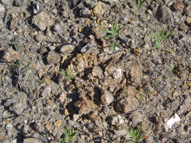
Some sediment contains no clastic particles, yet the material composing the sediment has been transported. In such sediment, the components were dissolved, transported in solution, and precipitated chemically. Such is the case with the source of the gypsum in this creek. Chemical sedimentary rocks result from lithification of organic or inorganic chemical precipitates. Most of these rocks contain only one important mineral, which forms the basis for classification. Gypsum and halite (rock salt) are the most common chemical rocks, formed by evaporation of water. As the water evaporates, dissolved matter is concentrated and evaporite deposits of salt begin to precipitate out as the chemical sedimentary rock.
-
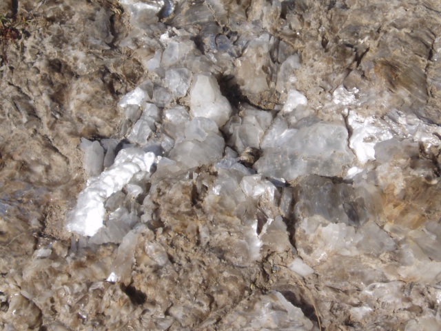
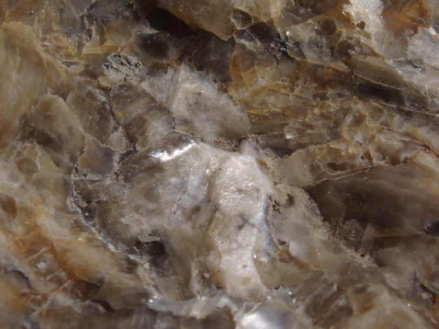
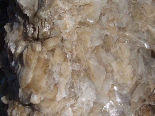
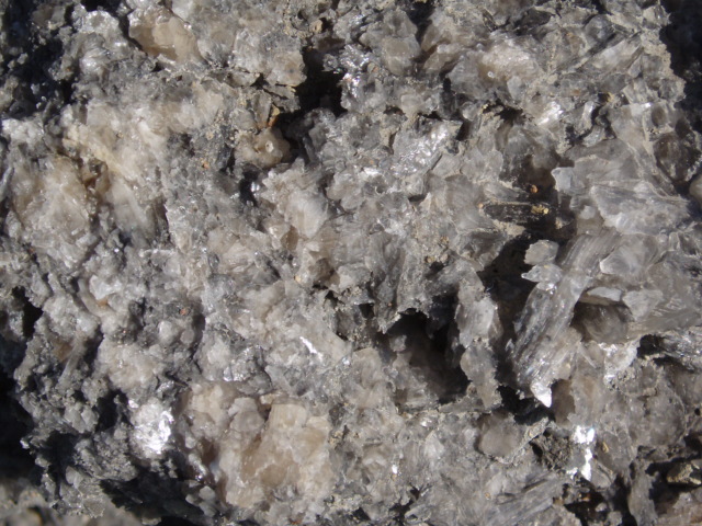
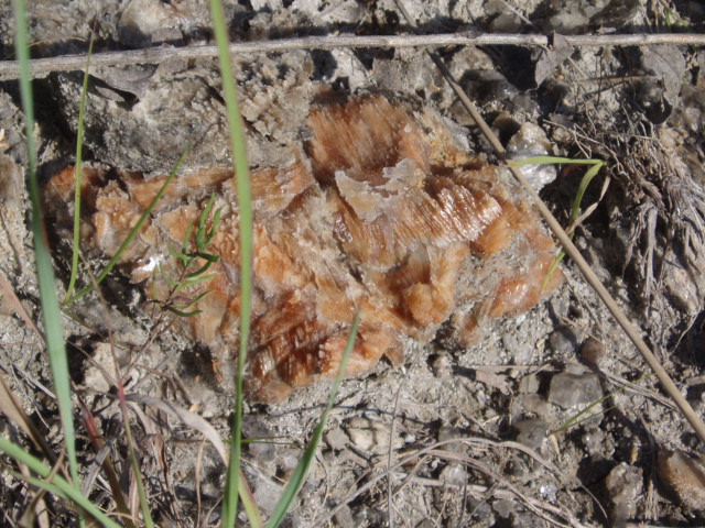
GYPSUM
In the Arkansas River Lowlands, gypsum crops out in Wichita along Gypsum Creek, which drains the eastern part of the city. Gypsum, a common mineral in the Arkansas River Lowlands, is made up of calcium sulfate with two molecules of water (CaSO4•2H20). All sulfate minerals contain the sulfate anion, (SO4)2-. Although many sulfate minerals are known, only two are common, and both are calcium sulfate minerals: gypsum and anhydrite (CaSO4). The mineral anhydrite is calcium sulfate without the bonded water molecules. Gypsum is colorless or white to light gray (or rarely, bright red), and is so soft that it can be scratched by a fingernail, which influences its mineral hardness rating on the Mohr Scale. Both forms of calcium sulfate occur when water evaporates - anhydrite when temperatures are high, and gypsum at lower temperatures.
Gypsum is divided into three varieties. The first, selenite, consists of flat, clear, diamond-shaped crystals. The second variety is called satin spar. It is white or pink, fibrous, and has a silky luster. It is found as thin layers in beds of rock gypsum and in certain shales. Both selenite and satin spar can be collected from these shales. The third variety is massive gypsum or rock gypsum. Rock gypsum is coarsely to finely granular, white to gray, and contains varying amounts of impurities.
-
ENVIRONMENTAL RESPONSIBILITY
(source)
Gypsum Creek, the spectacular tributary to the Arkansas River, provides a place for geological exploration and education as well as serving as an example of successful environmental responsibility. The City of Wichita initiated a restoration project for Gypsum Creek through the Clean Water Act in coordination with the EPA, the KS Dept of Health and Environment and the KS Dept of Wildlife and Parks. The project designed efforts for flood protection, to improve water quality, to re-establish dynamic equilibrium and restore the biological integrity of the native habitat. Efforts for Gypsum Creek at this spot included restoring pool-riffle sequence and a series of restored riparian wetlands.
ACCESS
The tasks required of this earthcache may be accomplished from either side of the creek. Access to the site is available from the southwest or from the northeast.
-
From the SW:
Access the area from the southwest at N 37° 39.518' W 097° 15.710' where you are in for a 0.2 mile hike on the southeast bank (between the highway and the creek) to get to the posted coordinates. The hike between the creek and the highway will provide you with the better mineral experience.
-
From the NE:
Access the area from the northeast by parking at N 37° 39.764' W 097° 15.323' where you are in for a 0.4 mile hike on the northwest bank.
Although not as packed with minerals as the other bank, approaching the site from the northeast will provide you with a comfortable asphalt bike path for easy walking. On the bike path, you will meet the first park bench at N 37° 39.679' W 097° 15.312' soon after walking down a slope from the parking spot. Another park bench awaits you at N 37° 39.592' W 097° 15.519' which is conveniently near the posted coordinates for this earthcache.
To claim the smiley, you will need to complete some tasks and email me the answers to a few questions. For everyone's benefit, please include the name of this Earthcache and your geocaching username at the begin of your e-mail. You may include additional details of your earthcache adventure in your email; good stories are always welcome. Send an email before posting your log, but you don't have to wait for a confirmation email from me before posting a qualifying log.
When posting your log for this earthcache, do not include spoiler answers in your log, lest you risk the unfortunate deletion of your valuable log. It is such a sad tragedy when an inappropriate log brings upon the inevitable destruction of itself.
On with the tasks; we have three measurements AND a photo. For some of these you will need to go down the slope to get by the bottom of the creek.

-
FIRST MEASUREMENT. Get a measurement (to the nearest foot) across the creek nearest the posted coordinates. At this spot are some rocks that may help if you want to chance stepping in the water. Due to the minerals, I would suggest that you don't get in bare-foot. Maybe you want to bring a second pair of shoes to wear in the water to protect your feet so you can wear some dry ones when you walk back to your vehicle. Don't drop your camera in the water!
Getting into the water is not necessary. You can get creative with your methods. You can bring a buddy with you who will be on the other side of the creek. Throw one end of your measuring device (rope, twine, kite string, a measuring tape that is hopefully long enough, etc.) to your buddy and the both of you can work together from opposite banks to get the distance.

Or you can measure it solo by attaching a bolt, or something heavy, to the end of some kite string. Swing the bolt around and let it fly through the air to land on the other side. Slowly pull the bolt toward you until some string dangling from a knot (tied before you threw the bolt over) lines up with the edge of the other bank. Mark your end, pull the string back to you and measure the length of string from your mark to the knot with dangly strings.

Include this measurement in your email. It is required to claim the smiley. Don't lose it.
-
SECOND MEASUREMENT. The second measurement is the distance (to the nearest inch) from the edge of the bank down (or up) to the surface of the water. The edge of the bank on either side has a ledge that you can walk on. The edge of the ledge is very distinct. Measure from the edge of the ledge down to the top of the water. If conditions are drought and there is no water, measure to the bottom of the creek. In the event that you visit this location after some heavy rains, the water may be above the walkable ledge. In this case, measure UP from the walkable ledge to the water surface. If the water is too deep, you probably should not be at this location until the water subsides.

Include this measurement in your email. It is required to claim the smiley. Don't lose it.
-
THIRD MEASUREMENT. How many paces does it take you to walk from down by the water's edge up to the top of the high bank?
Include this measurement in your email. It is required to claim the smiley. Don't lose it.
-
A PHOTO. Take a picture of your GPS receiver at the site and post the picture with your log. You can place the GPS receiver on the ground next to some minerals, or you can hold it up with the meanderings of Gypsum Creek visible in the background. You may be in the picture if you wish, but that is not required. This one isn't too hard, just a picture of your GPS receiver with something showing that you were there.
Congratulations to both 4America and tony477 for being First To Find!
 |
-
According to the Kansas Geological Society (KGS) specimens may be collected at this site.
-
Stuff a small trashbag into an easy-carry container (such as a 35mm film canister) and bring it with you to CITO the area.
-
While looking for nearby caches,
practice policies of Leave No Trace (LNT.org),
the center for outdoor ethics.
|
REMEMBER:
- Make the fair trade.
- Log your visit.
- Leave the site better than you found it.
- Protect the environment — always.
- Educate those around you.
- Find another cache!
Good luck, and may all your cache dreams come true.
—cantuland
|
 |