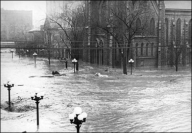
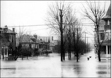
In March of 1913, the Miami Valley witnessed a natural disaster unparalleled in the region’s history. Three storms converged on the state, dumping 9 to 11 inches of rain on already soaked and frozen ground March 23-25, producing a 90-percent runoff and causing the Great Miami River and its tributary streams to overflow. Every city along the river was inundated with floodwaters. The amount of water that passed through the river channel in Dayton equaled the amount of water that flows over Niagara Falls in a 30-day period.
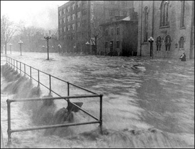
More than 360 people lost their lives; property damage exceeded $100 million (nearly $2 billion in today’s economy).
In the wake of this tragedy, Miami Valley citizens rallied to initiate plans to prevent future flooding. Some 23,000 citizens contributed more than $2 million to begin a comprehensive flood protection program on a valley-wide basis.
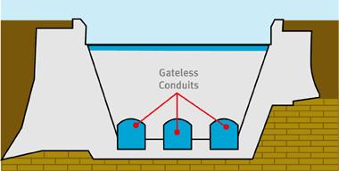
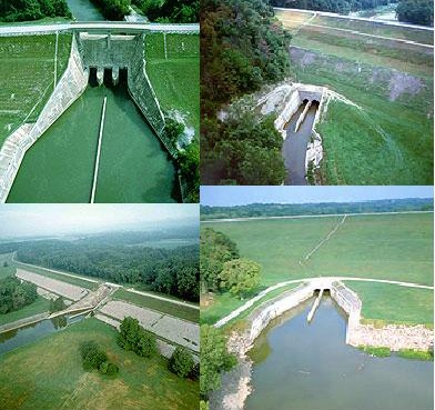
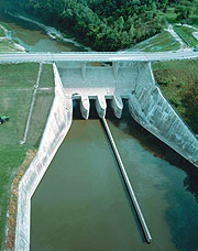
Arthur Morgan, an engineer based in Memphis, Tennessee, was hired to develop the system. The result was an unfailing flood protection system of five dry dams – Germantown, Englewood, Lockington, Taylorsville and Huffman – and levees that has protected the Miami Valley from flooding by the Great Miami River since 1922. The five dams created are not what one first visualizes when one thinks of a dam. They are dry dams. All of the dams are gateless with large concrete structures at their base with openings, or conduits, through which the river flows. During times of normal flow, the river passes through the dam unimpeded — there are no permanent pools of water behind the dams, which is why they are called "dry dams." The conduits in each dam are sized to allow the amount of water to flow through the dam that the river channels in the protected cities below can safely handle within their banks. Any excess flow backs up behind the dams in the retarding basins upstream of the dam.
The land upstream of a dam and below the elevation of the spillway that is reserved for temporary storage of floodwaters is called the retarding basin. MCD has flood easements on 35,650 acres of land upstream of the five dams in the retarding basins. Because the land is reserved for storage of floodwater, MCD has regulations controlling development. The land in the retarding basins is predominantly used for agriculture and parkland. A floodplain is the portion of a stream or river valley that is likely to flood. Floodplains include the riparian corridor, which is the vegetated or forested area alongside a stream.
Riparian buffers are the single most effective protection for our water resources in the Great Miami River Watershed. These strips of grass, shrubs and/or trees along the banks of rivers and streams filter polluted runoff and provide a transition zone between water and human land use.
Undeveloped natural floodplains provide free flood control and filter many pollutants from runoff. Natural riparian buffers have been lost in many places over the years. Restoring them in appropriate areas is an easy way to protect water quality, riverbank stability, wildlife and aesthetics in the Great Miami River Watershed. Landowners, communities and conservation organizations can all help restore and protect the riparian buffers.
Floodplain Preservation in the Great Miami River Watershed since inception, MCD has worked to protect the floodplains of rivers and streams in the Great Miami River Watershed. MCD manages more than 4,500 acres of protected floodplain land. Many of these areas were protected through local partnerships. All the information and more can be viewed at the Miami Conservancy District's Website.
There is another common piece to all of the dams. In this Earthcache, you will discover it. While the coordinates take you to RiverScape in Downtown Dayton, no where near any of the dams, they will take you to a fountain. This fountain helps explain the feature common to all the dams that I have left out of the description.
1. What is this feature? (more than just being a dry dam)
2. What does this feature do to the water flowing downstream?
3. Where (location and part of house) did the engineers figure this out? (hint: it is NOT the attic or basement, and it is quite normal for it to hold lots of water)
If you fail to complete ANY of the requirements, I WILL RESERVE THE RIGHT TO DELETE YOUR LOG. All the information can be found AT THE COORDINATES.
If you view a satellite picture of the cache sight you will notice at the time of the picture, it is underwater. In times of high water, please use common sense on whether or not to attempt the cache. But most of the time, that area is accessible to foot and bike traffic.
Happy caching!
Congratulations to MTMAN2 for finding #1300!!!
Congratulations to Curly Tiger for finding #700!!!
Congratulations to johnsteinke for EARTHCACHE find #1!!!
Congratulations to counselortroi for EARTHCACHE find #1!!!
Congratulations to mrmikeandy for EARTHCACHE find #1!!!
Congratulations to CycloneSteve for OHIO EARTHCACHE find #1!!!
Congratulations to xTheProphetess for EARTHCAHCE find #1!!!
Congratulations to brewaskew for EARTHCACHE find #1!!!
Congratulations to Fortislander80 for EARTHCACHE find #30 AND OVERALL FIND #2,000!!!