Es gibt viele schöne Brunnen in unserer Gegend, die man leider
meist nur als Insider kennt.
Es wäre schön, wenn ihr euch auch an der Serie beteiligt, sofern
ihr einen netten Brunnen kennt.
Der Cachename sollte allerdings immer mit "Brunnencache - (+Name
des Ortes/Brunnen)" lauten um ihn der Serie eindeutig zuordnen zu
können.
Wenn ihr noch ein paar Infos zu dem Objekt findet schreibt sie mit
in die Beschreibung rein.
Dieser Multi führt euch an den meisten der 18 Brunnen der
Brunnenstadt Külsheim vorbei.
Hier sind die Aufgaben in Kompaktform: (Übersichtlicher sind sie in
der Wegpunkt-Liste zu finden)
Stage 1:
Vom Parkplatz an der Kirche vorbei und die Uissigheimer Straße
runter kommt ihr zu Stage 1. An diesem Brunnen ist ein Schlussstein
mit einer Jahrszahl eingemauert. Diese lautet 19ab.
Stage 2:
Folgt der Haupstraße zum Obertorbrunnen. Auf der Rückseite des
senkrechten Steins sind c Dübellöcher.
Stage 3:
An der Hauptstraße kommt jetzt schon der Narrenbrunnen. Dort könnt
ihr euch auf d stählernen Sitzgelegenheiten
niederlassen.
Stage 4:
Folgt nun der Bergstraße zum Gießbachbrunnen. Hier hat die Stadt
e Metalldeckel in den Boden eingelassen (Radius 3m um
Brunnen).
Stage 5:
Geht jetzt durch die schmale Gasse zum Spitalbrunnen. Dieser wird
von f stählerenen Wächtern vor dem Verkehr geschützt. (Einer
ist abhanden gekommen, desshalb f = Anzahl + 1)
Stage 6:
Um die Ecke seht ihr den Rathausbrunnen. An ihm sind g
Wappen angebracht. Das Wasser fließt aus h Mündern in die
Brunnenschale. Sucht von hier aus den nächsten Brunnen vor einer
Kapelle.
Stage 7:
Begebt euch zum Dreischalenbrunnen und zählt die i
"Hundsbrunzer". Aus der mittleren Schale fließt das Wasser durch
k Rohre in die untere Schale. Diese Schale hat mehrere
Buchten am Rand. Zählt sie, die Quersumme davon ist j.
Stage 8:
Geht jetzt wieder den Berg hoch zum Löchleinsbrunnen. Dort muss man
l Stufen hinabsteigen um zum Wasser zu kommen
Stage 9:
Sucht jetzt im Badbrunnenweg diesen Brunnen. Ermittelt den Ostwert
wo es plätschert (E 9°31.2m6) und zählt die n alten
Schrauben mit Vierkantmutter am Rand.
Stage 10:
Durch enge Gässchen gehts weiter. Am Edelsbrunnen ist ein
Hinweisschild angebracht. Wenn ihr vor diesem steht schaut ihr auf
ein Fachwerkhaus. An einem Bogen ist die Jahreszahl
1p2o eingemeiselt.
Stage 11:
Wieder zurück auf der Haupstraße halten auf dem Weedbrunnen
q Engel ein Wappen.
Stage 12:
Das alte Stadtende markiert der Untertorbrunnen. Das Becken ist
r,s1m lang.
Stage 13:
Genau gegenüber gehts schon weiter. Am Moretbrunnnen speien
u Düsen Wasser nach oben, das in t Wasserfällen nach
unten fällt.
Stage 14:
Am nächsten Brunnen in der Boxtalstraße sind v Ringe zum
anbinden von Tieren. Die Säule misst w0cm im Quadrat.
Stage 15:
Der letzte Brunnen bei dieser Stadtrunde: Neben dem Boxhagelbrunnen
steht ein Hinweisschild auf den goelogischen Rundweg. Darunter ist
eine blaue Markierung LTx.
Final:
Am Final ist der GPS-Empfang sehr schlecht. Bedenkt einfach die
Größe der Kiste (2,4l) und ihr solltet sie finden. Ansonsten passt
auf, dass euch kein Gebäudeteil auf den Kopf fällt.
Wenn ihr alle Stages besichtigt habt (und die Aufgabe korrekt
gelöst habt), seid ihr im Besitz von etlichen Zahlen mit denen ihr
die Final-Koordinaten berechnen könnt. Ein Metermaß könnte
euch bei 2 Stages gute Dienste leisten, ansonsten braucht ihr ein
besonders gutes Augenmaß.
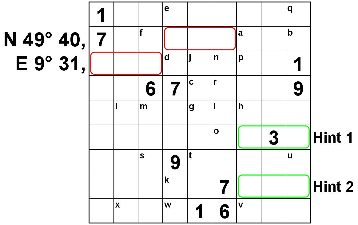
Setzt einfach die ermittelten Zahlen in das SUDOKU oben ein und
löst es. Ihr könnt dann die Koordinaten des Final direkt ablesen
(im roten Kasten).
Um mögliche Ablese- oder Zählfehler zu vermeiden sind hier die
Zahlen, die ihr ermittlet haben solltet:
1x1, 4x2, 4x3, 6x4, 4x5, 1x6, 1x7, 2x8, 1x9
Wer noch nicht ganz so viele SUDOKUs gelöst hat, dem könnte
das oder der Hint
evtl. weiterhelfen.
Deine Lösung für die Koordinaten dieses Rätsels kannst du auf
geochecker.com überprüfen.
Geochecker.com.
Wer noch mehr über die Brunnen von Külsheim erfahren möchte, kann
gerne hier
weiterlesen.
Dieser Multi-Cache ist fast komplett für Kinderwagen geeignet.
Um zum Final zu kommen, muss man allerdings ein paar Treppen
benutzen, die sich nicht umgehen lassen.
Die Gesamtdauer für diesen Cache hängt sehr stark davon ab, wie
schnell ihr das SUDOKU lösen könnt. Der reine Weg ist in 20 Minuten
zu bewältigen (wenn man ein ordentliches Tempo vorlegt).
Ich wünsche euch jetzt viel Spaß bei eurer Entdeckungstour durch
Külsheim, beim SUDOKU-Lösen und beim Cache-Heben.
(Das sind ja gleich drei Wünsche auf einmal. Das geht nun wirklich
nicht  )
)
P.S. Das SUDOKU war euch zu leicht? Ihr sucht was Schwereres? Im
Cache ist ein Rätsel-Block. Reisst einfach ein Blatt ab (Bitte
melden wenn fast leer), löst das Rätsel und hebt auch noch den
BONUS (GC1DB18) . Viel Spaß.
Erstaustattung: Logbuch, Stift, Aufgeben für Bonus, Geduldsspiel,
TB
There are many beautiful fountains in our area, but
unfortunately you only them as insider.
This Multi leads you to most of the 18 fountains in the "city of
fountains" Külsheim.
Here all tasks in a compact form: (You will find them clearly
arranged in the waypoint list)
Stage 1:
Leave the parking place and go past the church and down to
Uissigheimer Straße to stage 1. In this Fountain there is a
keystone with a year. This is 19ab.
Stage 2:
Follow the Hauptstaße to Obertorbrunnen. On the back of the
vertical stone you can find c dowel-holes.
Stage 3:
At the Haupstraße the next fountain is Narrenbrunnen. Here you can
sit down on d seats of steel.
Stage 4:
Now follow the Bergstrape to the Gießbachbrunnen. There are
e covers in the ground (3m around the fountain).
Stage 5:
Go though a small lane to the Spitalbrunnen. F guards
(steel) keep it secure from the traffic. (One disappeard, therefore
F = Number + 1)
Stage 6:
Around the corner you see the Rathausbrunnen. Here you can find
g crests. At this fountain the water comes out or h
mouths. From here look for the next fountain in front of a
chappel.
Stage 7:
Go to the Dreischalenbrunnen and count the i "dog-pissers"
(stones where dogs are pissing at). The water is leaving the bassin
in the middle through k pipes. The big bassin has some bays,
count them. The cross sum is j.
Stage 8:
Go up the hill to the Löchleinsbrunnen. Here you have to go down
l Steps to get to the water.
Stage 9:
Now search the fountain in the Badbrunnenweg. Get the
East-coordinates where it dabble (E9°31.2m6) and count the
n old screews with square-nuts at ist edge.
Stage 10:
You now have to go throught narrow lanes. At the Edelsbrunnen there
is a sign. When you stand there you will look at a timbered house.
At a bow there you can see the year 1p2o.
Stage 11:
Back on the Hauptstraße on top of the Weedbrunnen q angels
are holding a crest.
Stage 12:
The Untertorbrunnen marks th former end of the city. It's bassin is
r,s1m long.
Stage 13:
At the other side of the road the trip continues. At the
Moretbrunnen u sprinkler spit water and with t
cascades it leaves the fountain.
Stage 14:
At the next fountain in the Boxtalstraße there are v rings
to tie animals. The column measers w0cm square.
Stage 15:
The last fountain in our trip: Beside the Boxhagelbrunnen there is
a sign of the goelogical path. Below this there is a blue Sign
LTx.
Final:
At the Final you will have problem with the GPS-signal. But if you
think of the size of the cache (2,4l) you will find it. And look
out, that no part of a building is falling on your head.
After visiting all stages (and answering all questions) you will
have a lot of numbers to find out the final-coordinates. A tape
measure can help you at two stages, otherwise you need good
visual judgement.
Put the numbers in the SUDOKU above and solve it. Then you can see
the Koordinates directly (in red boxes).
To avoid mistakes at the stages you should retreaved following
numbers:
1x1, 4x2, 4x3, 6x4, 4x5, 1x6, 1x7, 2x8, 1x9
If you are not that good in solving SUDOKU's this or the hint probably
can help you.
You can check your coordinates on Geochecker.com.
Geochecker.com.
If you want to learn more about the fountains of Külsheim have a
look here (only
in german).
You can do this Multi-Cache almost kompletly with trollies. Only at
the Final you have to go some steps you can't walk around.
How long you need for this Multi depends on how fast you solve the
SUDOKU. You will probably need 20 minutes only walking on your tour
(if you walk fast).
Now I wish you fun on your tour through Külsheim, while solving
the SUDOKU and finding the Final.
P.S. The SUDOKU was too easy? You are searching something more
difficult? In the cache you can find an other puzzle. Tear out a
sheet (Short mail if almost empty), solve the puzzle and find the
BONUS (GC1DB18). Have fun.
First inventury: Log, pen, puzzle for Bonus, wooden puzzle,
TB