Donauversinkung

Die Donauversinkung (auch als Donauversickerung bezeichnet) ist eine Flussanzapfung im Naturpark Obere Donau. Zwischen Immendingen und Möhringen und bei Fridingen (Landkreis Tuttlingen) versickert Wasser der Donau an verschiedenen Stellen flächig im Flussbett.
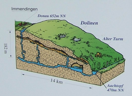
Das Donauwasser versickert hier in einem Karstwassersystem der Wohlgeschichteten Kalke des Weißen Jura und tritt in verschwammten, liegenden Bankkalken des Weißen Jura (ki 4) im rund zwölf Kilometer entfernten Aachtopf wieder aus. Es fließt sodann als Radolfzeller Aach bei Radolfzell in den Bodensee. Somit fließt ein Teil des Donauquellwassers auch in den Rhein. Diese geografische Situation ist eine markante Besonderheit der großen Europäischen Wasserscheide, welche die Einzugsgebiete der Nordsee und des Schwarzen Meeres trennt.
Die erste Nachricht einer Vollversickerung stammt aus dem Jahr 1874. Die Versickerungsmenge hat sich von Jahr zu Jahr gesteigert. Während Messungen von 1884 bis 1904 jährlich 80 Vollversickerungstage ergaben, steigerten sich diese von 1933 bis 1937 auf 209 Tage, von 1938 bis 1945 auf 270 Tage. Einen Rekord erbrachte das Jahr 1921 mit 309 Versickerungstagen.
Versickerungen erfolgen durch eine Reihe von kleinen bis sehr kleinen Rissen und Klüften. Die Verkarstung befindet sich an diesen Stellen also noch in einem frühen Entwicklungsstadium. Das Karstsystem bis zum Aachtopf mag dagegen schon weit entwickelt sein. In den 1960er Jahren hat Jochen Hasenmayer vom Aachtopf aus 400 m einer großen, klammförmigen Quellhöhle die Aachhöhle entdeckt und erforscht. Wie sich das Fortschreiten der Verkarstung an diesen Versickerungsstrecken entwickelt, ist nicht eindeutig. Erweiterungen, Änderungen oder gar Einstürze im Untergrundsystem, die Entwicklung von Dolinen oder Ponoren (Schlucklöchern) wie in anderen Karstgebieten vorhanden, ist denkbar. Weitergehende Veränderungen in geologischen Zeiträumen können die völlige Umleitung der hiesigen Donau in die Radolfzeller Aach zum Rhein sein. Eine Flussanzapfung hat eine so genannte Feldberg-Donau in der Würmeiszeit bereits bei Blumberg (Wutachknie bei Blumberg) erlebt. Die Nebenflüsschen Krähenbach in Möhringen und Elta in Tuttlingen würden dann zu Quellflüssen der Donau.
Die Hauptversickerungsstelle liegt am Gewann „Brühl“ zwischen Immendingen und Möhringen (47° 55' 56? N, 8° 45' 49? O). Die Donau gibt Messungen zufolge jährlich ca. 7.000 Tonnen Kalk, das sind 2.700 qm, an das Karstsystem des Aachtopfs ab.

The Donau (Danube) springs in the Schwarzwald (Black Forest). After leaving the Black Forest the Danube flows to the north east at the southern rim of the Schwäbische Alb (Swabian Jura) and later the Fränkische Alb (Frankian Jura) towards Regensburg. He it bends to south east and leaves Germany near Passau. After many hundred Kilometers it flows into the Black Sea.
But from the water which springs at the Danube Spring, only a small part arrives at the Black Sea. Most of it flows into the North Sea. This seems absurd, as the Danube flows into the Black Sea, and the Rhine flows into the North Sea at the opposite end of Europe. The border between their drainage basins is called the European watershed or European drainage divide running through middle and eastern Europe. So the water of the Danube crosses the watershed.
It seems strange, but the explanation is rather simple: the upper Danube area is catchment area for two big river systems, as the water is forked and flows into two rivers, Rhine and Danube, at the same time. But the catchment area or drainage basin, is defined as an area drained by a (single) stream or another body of water. The limits of a given catchment area are the heights of land - often called drainage divides, or watersheds - separating it from neighboring drainage systems. This hydrogeologic water-shed-model is too simple to describe the complext karst hydrogeology of the upper danube.
The Danube sink is rather unspectacular, but its a hydrogeologic site of world fame! The water is not flowing across the water shed, but passes the border undergound. Sinks in the bed of the danube at Donaueschingen and Tuttlingen, and later again near Fridingen, swallow a certain amount of water. The biggest swallow holes are at the Brühl in Immendingen, more sinks are near the railroad bridge. The swallow holes near Fridingen are about 2km from the town in a loop of the Danube, and are only accessible by foot. At some locations signs with schematic drawings explain the geologic situation.
The karstified layers of the Malm (late Jurassic) fall to the south and are covered by the much younger sediments of the Süßwassermolasse, the remains of a great lake similar to north Americas Great Lakes. The water flows in the Malm limestone below the overlaying sediments to the Aachtopf (Aach spring) in the south. The speed of the water is from Brühl aboutr 180 m/s and from Fridingen about 100 m/s. The Aach is a tributary of the Rhine.
During the centuries, the loss of water in the Danube increased. The first time the Danube fell completely dry was in 1874. Now the number of days with complete loss of water increased continuously. The maximum was reached 1921 with 309 days!
In the days of complete loss, the people talk about Schwarzwald-Donau (Black forest Danube), from the springs to the swallow holes, and the Alb-Donau (Jura Danube). The Jura Danube is "revived" by two tributaries, the Krähenbach and the Elta.
While it seems, that the amout of water swallowed by the underground cave system increases continually, the days of complete loss are not a sign of higher loss on these days, but of lesswater in the river. In summer and especially in dry years the amount of water in the danube is smaller than the amount swallowed by the cave system. Increasing precipitation since 1950 reduced the time of complete loss.
The water of the rivers Danube and Aach was always valuable for running mills. And as Danube and Aachtopf were located in (then) different states, there were soon struggles and fights for the water. The people at the danube tried to reduce the loss by filling the swallow holes with concrete. Soon the people at the Aach mentioned the decrease of water. At last the case was sentenced at the court in the 1820s.
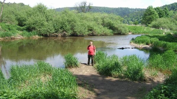
Bitte macht an der Versickerungsstelle ein Foto von euch mit der im Hintergrund hoffentlich versickerten Donau. (siehe Foto unten) Als ich vor Ort war hatte ich leider kein Glück die Donau an einem Versickerungstag anzutreffen.
Bitte beantwortet noch folgende Frage:
Mit welchen drei Substanzen gelang dem Geologen Adolf Knop, der Nachweis, dass das Wasser der Donauversinkung im Aachtopf Nach 60 Stunden wieder austritt?
Sende die Antwort an GC1CZEP-Donauversinkung@cachewerkstatt.de und Ihr könnt sofort mit Eurem Foto loggen.
Es ist nicht notwendig, auf eine Logerlaubnis zu warten !
Please upload a photograph of yourself with the (hopefully) “lost” Danube behind you (see photo below). Unfortunately, when I was there, I was out of luck: the Danube was not drained that day.
You will also need to answer the following question:
The geologist Adolf Knopp managed to prove that the water of the Danube sink re-emerges in the Aachtopf 60 hours later. Which 3 substances did he use for this proof?
Send the answer by email GC1CZEP-Donauversinkung@cachewerkstatt.de to me and you can log in immediately with your photo.
It is not necessary to wait for log permission!