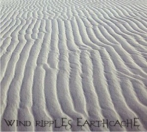

In geology, ripple marks are sedimentary structures that indicate agitation by water (current or waves) or wind. This cache looks at the wind-created variety.
Wind Ripples
Wind ripples are produced by the action of wind on non-cohesive material.
Movement of Sand in a Wind Regime
According to Bagnold (1954), (sand) 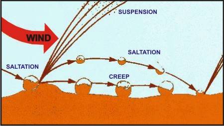 grain motion of three types is possible: Suspension, saltation, and surface creep. He adds that for the production of ripples and other bedforms in a wind regime, saltation and surface creep are the most important. When a grain flying in the air strikes a bigger grain too large to move, the smaller grain bounces off with very little loss of momentum. If the grain strikes the surface of loose sand consisting of smaller grains, it disperses most of its energy among the grains it strikes, ejecting them into the air. These in turn again strike the surface and either rebound or eject other grains. For any given power of wind, there exists a definite average or characteristic path. This saltation process, or grains moving through saltation, partly transfers momentum to other grains that are not lifted but are merely pressed forward, so that a continuous surface creep of grains results.
In a sand admixture finer grains move by saltation and coarser ones move chiefly by creep, as they are too big to be lifted.
Bagnold (1954) defines sand ripples as wavy surface forms on sandy surfaces whose wavelength depends on the wind strength, and remains constant as time goes on. Ripple wavelengths increase with the wind gradient, but ripples flatten out and disappear when the wind rises above a value of about three times the threshold value for the particuular sand.
Wind ripples generally have straight long, parallel crests, and are asymmetrical, with high ripple indices. They may show well developed bifurcating of crests. There is a tendency for curved ripples to straighten out until they lie at right angles to the wind direction (Bagnold, 1954).
Bagnold (1954) considers that the spacing between crests is equal to the length of the characteristic path of saltating grains. The latter is in turn a function of wind velocity. Sharp (1963), however, feels that the wavelength of a ripple is strongly influenced by the size of the grains composing a ripple and also by wind velocity, and that no relationship between the characteristic path of saltating grains and ripple wavelength seems to be required. Investigations by Bagnold (1954) and Sharp (1963) indicate that a lee-side eddy, although present, has no significant influence on the ripple form and the development of wind ripples. The eddy is present when there is no sand transport.
However, ripples are but a smaller component of a much larger aeolian transport system that are the (sand) dunes.
Sand Dunes
Out of all the aeolian sand deposits, sand dunes are the most impressive and important features of a desert environment. A sand dune may be defined as a hill of sand deposited by wind, which rises to a single summit and possess a slip face. Sand dunes may exist single, but normally they occur in 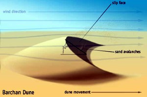 colonies. Sand dunes are found in the flat areas of a desert; such a surface is sometimes covered with coarse-grained sediments. Sand dunes develop wherever a sand-laden wind deposits sand as a random patch. This patch slowly grows in height as a mound, and finally a slip face is formed. Bagnold (1954) observed that the minimum height of a slip face in a wind regime is about 30 cm. Now, the sand mound migrates forward as a result of the advance of the slip face. Despite their migration, sand dunes are capable of retaining their shape as long as the wind conditions remain the same.
An exhaustive account of the physical conditions and processes in sand dunes is given by Bagnold (1954). Sand dunes extensively develop also in marine, coastal and river environments.
 Depending upon wind conditions, sand type, and supply of sand, dunes may acquire varied size and shapes. Different authors have attempted to classify sand dunes (e.g. see Melton, 1940; Bagnold, 1954; Cooper, 1958; 1967; Holm, 1960; McKee, 1966).
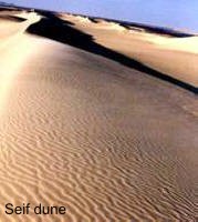
Sand dunes may be oriented perpendicular to the prevalent wind, e.g., barchan dunes, transverse dunes; parallel to the prevalent wind, e. g., seif dunes; or they may acquire complex forms, e.g., dome-shaped dunes, star-shaped dunes.
Following are the more important sand dune types as defined by McKee (1966):
1. barchan dunes (see image)
2. transverse dunes
3. parabolic dunes
4. seif dunes (see image)
5. star dunes
6. dome-shaped dunes
7. reversing dunes.
Out of all these forms, barchan dunes and seif dunes are the most abundant and important ones.
Claiming the earthcache
The above coordinates will take you to a dynamic dune field where you are not only confronted with several dunes but also millions of ripple marks. Please tell me 1- what type of dunes do you see around you and 2- what is the predominat wind direction deduced from the orientation of the ripple marks. Send me your answers via e-mail through my GC profile before logging and I will validate your found.
Note: Let's have some nice macro photos of wind ripples in your logs but none that show the horizon.
Reference: Reineck, H.E. and Singh, I.B., 1980. Depositional setimentary environments. Springer-Verlag, Berlin-Heideberg-New York, 439 pp.
Happy earthcaching!
 The most exciting way to learn about the Earth and its processes is to get into the outdoors and experience it first-hand. Visiting an Earthcache is a great outdoor activity the whole family can enjoy. An Earthcache is a special place that people can visit to learn about a unique geoscience feature or aspect of our Earth. Earthcaches include a set of educational notes and the details about where to find the location (latitude and longitude). Visitors to Earthcaches can see how our planet has been shaped by geological processes, how we manage the resources and how scientists gather evidence to learn about the Earth. To find out more click HERE.