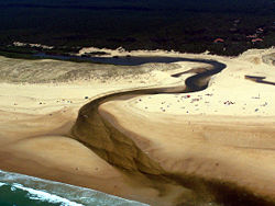
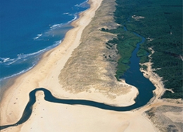
Le littoral des Landes de Gascogne est protégé par un cordon dunaire de 200 km privant de nombreux petits fleuves côtiers d'accès à l'Océan et conduisant à la formation d'un chapelet de lacs et étangs dont les seuls exutoires sont les « courants ».
Une quarantaine de lacs et étangs jalonnent ce paysage, à l’abri de la dune protectrice, entre littoral et terres intérieures. Mais seules six embouchures (boucau en Gascon) jouent le rôle de déversoir vers l’Océan , parmi lesquelles quatre portent le nom de courant :
- courant de Mimizan
- courant de Contis
- courant d’Huchet
- courant de Soustons.
L’étang de Léon et le courant d’Huchet, classés en réserve naturelle en 1981 représentent le dernier ensemble étang et de courant du littoral Aquitain ayant préservé en grande partie son caractère naturel car n’ayant pas subi d’artificialisation irréversible à l’image de son embouchure non endiguée qui divague au fil des saisons.
La particularité de ce site est la grande diversité de milieux qui le compose avec l’étang de Léon et ses rives marécageuses, le courant d’Huchet et sa forêt galerie, les marais et tourbières, la forêt de pin et le cordon dunaire littoral.
* pour valider la cache vous devez :
1) Vous rendre au waypoint PANNEAU (43º51,699N - 001º23,254W) et me dire à quoi correspond le panneau principal
2) Me donner le nom du marais situé au milieu du « courant »
3) Prendre une photo de l’embouchure. (Cette dernière sera ajoutée à la galerie et permettra de voir le déplacement de l’embouchure dans le temps)
English :
The coast of Landes of Gascony is protected by a cordon dunaire of 200 km depriving numerous small coastal rivers of access to the Ocean and leading to the formation of a rosary of lakes and ponds the only releases of which are the "currents"(courant).
About forty lakes and ponds mark out this coastal, shielded from the dune defender, between coast and internal lands. But only six mouths (“boucau” in Gascon) play the role of overflow towards the Ocean, among whom four carry the name of “courant”:
- courant de Mimizan
- courant de Contis
- courant d’Huchet
- courant de Soustons.
Léon's pond and “courant” of Huchet, classified in nature reserve in 1981 represent the last set pond and of “courant” of the coast Aquitain having protected largely its character natural because not having undergone of irreversible artificialisation just like its not diked mouth which raves in the course of the seasons.
The peculiarity of this site is the big variety of environments which composes it with Léon's pond and the swampy banks, the courent de Huchet and its forest gallery, swamps and peat bogs, the forest of pine and the cordon dunaire littoral.
* To validate the cache you have to:
1) Go to the waypoint PANNEAU (43º51,699N - 001º23,254W) and say to me what corresponds the main pannel.
2) Give the name of the swamp (marais) situated in the middle of the "courant"
3) Take a photo of the mouth. ( This last one will be added to the gallery and will allow to see the movement of the mouth in the time)
Note : avant les travaux entamés dès 1788 par Nicolas Brémontier (1738-1809) pour fixer la dune grâce aux végétaux (oyat, liseron des sables, euphorbe du littoral, panicaut de mer), celle-ci se déplaçait au gré des tempêtes et des vents, entrant parfois de plusieurs kilomètres dans les terres, menaçant les habitations et obstruant le cours des courants, provoquant des inondations et les obligeant à changer de débouché.
English note: Indeed, before the works begun from 1788 by Nicolas Brémontier ( 1738-1809 ) to fix the dune thanks to vegetables (oyat, bindweed of sands, spurge of the coast, panicaut of sea), this one moved according to storms and winds, sometimes entering several kilometres lands, threatening houses and blocking the course of the “courants”, provoking floods and obliging them to change outlet.