Jökulsárlón


The Glacier Lagoon (Jökulsárlón), a glacial river lagoon in Iceland, is close to highway number one, about 350 km east from Reykjavík, and one of Icelands greatest wonders of nature. It is situated at the south end of the great glacier Vatnajökull between Skaftafell National Park and Höfn.
At the time when the first settlers arrived in Iceland, the edge of Breiðamerkurjökull, an outlet of the glacier Vatnajökull, is thought to have been about 20 km further north than it is now.
The climate began to cool in about the year 1200, the cold spell reaching a peak in the period 1600-1900, which is sometimes known as the "Little Ice Age". As a result, the glacier advanced until about 1890, reaching a point only about 1 km from the coast at Jökulsá river (today 3kms away from coast).
The eastern part of the glacier eroded the sediments of Breiðamerkursandur to a depth of up to 300 m below sea level, the sediment being carried forward by the river Jökulsá. Without the river the glacier could not have eroded such a deep basin, because it is the river that carries the sediment to the sea.
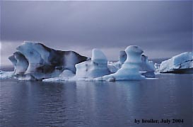
The warm period from 1920 to 1965 caused great changes in Breiðamerkurjökull glacier. It retreated very quickly, leaving a lagoon up to 190 m deep where the glacier snout had been, and several kilometres of glacial moraines were exposed on both sides of the lagoon. Appearing first only in 1934-1935, the lake grew from 7.9 km² in 1975 to at least 18 km² today because of heavy melting of the Icelandic glaciers. Large blocks of ice calve constantly off the edge of the glacier, which is about 30 m high, keeping the lagoon stocked with icebergs, which float on the lagoon.
Jökulsarlon is part of one of the shortest rivers in Iceland, Jökulsá á Breidamerkursandi, which is only 1500 metres (4900 feet) long and empties from the lake.
The surface is at sea level and sea water flows into the lagoon at high tide.
In the summertime, one has to watch out for the skuas, big seagulls which have their nests on the ground around the lake and which can occasionally become aggressive. If you are lucky you will see some seals.
To log this cache as a found you have to email me the awnser to the following questions:
1.) Which different colours do the icebergs floating on the lagoon have?
2.) Explain me in simple words the cause for two of those colours.
3.) Upload in your log a photo that shows you at Jökulsárlón to proove you had been physically there (re-allowed by GC since June 2019).
4.) For this is sagaland: if an iceberg reminds you of something, please make a photo, which you upload in your log and tell us what it reminds you of (optionally).
5.) Edit 2.9.2018: While here why not log this webcam-cache as well? Jökulsarlon Webcam Cache.
Old holiday-logs are wellcome if you still can fulfil log-conditions.
Logs without the required e-mail will be deleted without comment. Due to "administration" of the log-permissions it is nessecary that every team send an e-mail by itsself even if you were there together. Do not wait for log-permission, just log your found directly after sending the mail; we will contact you if there is something wrong.
To see whether the weather conditions at Jökulsárlón are favourable, check this link.
Quellen:
http://www.ismennt.is/not/hinni/lon/main.asp
http://en.wikipedia.org/wiki/J%C3%B6kulsarlon