Wydmy ruchome, pohyblive duny, movable dunes
polski:
Ruchome wydmy sa Prawdziwym unikatem Slowinskiego Parku
Narodowego.
Najstarsze wydmy, utworzone w procesach eolicznych po ustapieniu
lodowca, znajduja sie na poludnie od jeziora Lebsko. Wspólczesnie
one calkowicie utrwalone, pokryte lasem, a czesciowo nawet
zagospodarowane i uprawiane, a przez to nie dostrzegane na
codzien.
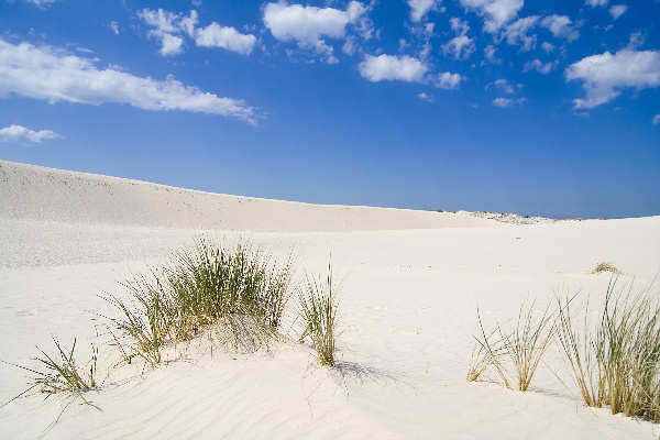
Zjawiskiem unikatowym na skale europejska sa natomiast znacznie
mlodsze wydmy ciagnace sie wzdluz mierzei. Wsród nich najbardziej
znane jest pasmo aktywnych, wedrujacych piasków, zwane Bialymi
Górami, polozone miedzy jeziorem Lebsko a morzem. Biale Góry
znajduja sie w centralnej czesci Mierzei Lebskiej. Zajmuja one
obszar blisko 500 ha Nie ulega watpliwosci, ze to wlasnie ruchome
piaski wydm sa nieformalnym symbolem Parku wyrózniajac go sposród
innych parków narodowych. Tworza jedyny w swoim rodzaju, urzekajacy
dzikoscia i rozmaitoscia form, krajobraz quasi-pustynny. Jest on
widoczny nawet z kosmosu, a na Ziemi podziwiany z wielu miejsc, w
tym z Rowokolu - najwiekszego wyniesienia morenowego - lub z wydmy
Lackiej.
Na zachód od nich usytuowane sa Sowie Góry - czesciowo utrwalone
wydmy w okolicy Czolpina. Na najwyzszej z nich, calkowicie
ustabilizowanej znajduje sie latarnia morska. Na wschód od Sowich
Gór znajduje sie pojedyncza, bardzo aktywna, rozlegla wydma
Czolpinska, która wydzielila sie z dawnego pasma wydm. Obecnie
prowadzi przez nia szlak turystyczny.
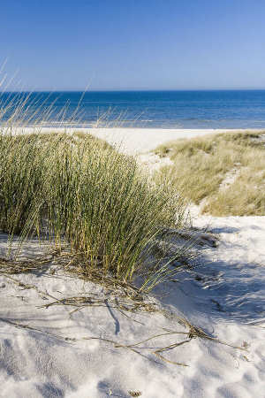
Powstanie wydm: wyrzucany przez morze piasek jest osuszany przez
slonce i wiatr i wywiewany dalej w glab ladu. Efektem tego procesu
sa ruchome wydmy, których wysokosc przekracza 30 metrów. Tempo
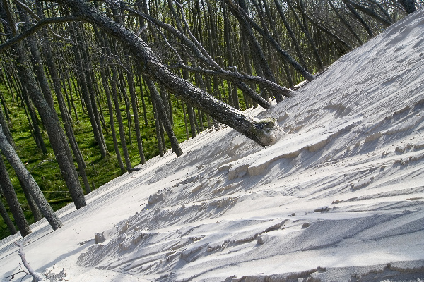
przemieszczania sie to od 3,5 do 10 metrów na rok. Wydmy zasypuja
wszystko co napotkaja na swej drodze. Czestym widokiem sa
przysypane do polowy drzewa. Wydmy zwiekszaja swoja powierzchnie
jednoczesnie tracac nieco na wysokosci, caly czas podazajac w glab
ladu. Na wycieczke do ruchomych wydm wyrusza sie z Rabki (na zachód
od Leby). W Rabce znajduje sie punk muzealny Slowinskiego Parku
Narodowego z niewielka wystawa fotograficzna parku. Na pobliskim
placyku mozna wypozyczyc rower. Na pierwszych 3 km kursuja równiez
teleksy i bryczki. Po drodze na wydmy mija sie jeszcze jedna
atrakcje - resztki poniemieckiego poligonu doswiadczalnego z
wyrzutniami rakiet.
Podane wspolrzedne zaprowadza Cie opodal wydmu ruchomu (Gora
Lacka).
Do zalogowania sie do tego Earthcache'a musisz:
1. Zrobic fotke Twojego GPS (mozesz tez
na niej byc) a wydmy ruchome (Gory Lackie-najwyzsze wydmy
opodal)
2. Zrobic fotke jakikolwiego interesujacego cecha (drzewo,
trawa…)
3. Zmierzyc najwyzszu wysokoscu tej wydmy (wysokosc wierzcholku
wydmy minus wysokosc podnoze wydmy)
Prosze przeslac odpowiedz nam na e-mail
cesky:
Pohyblive duny jsou pravym unikatem nejen Slowinskeho narodniho
parku, ale cele Evropy. Je prihodne, ze symbolem Slowinskeho
narodniho parku je racek stribrity, ktery se vznasi nad dunami a
modrou vodou.
Tyto bile pisecne presypy jsou dokonce videt z vesmiru a svym
vzhledem pripominaji poust tahnouci se v delce 18 km podel pobrezi
Baltskeho more a patri mezi nejnavstevovanejsi casti Slowinskeho
narodniho parku.
Mohutne hromady bileho a zluteho pisku, ktere nejsou zpevnene
vegetaci, jsou nejvetsi oblasti pisecnych dun v Evrope. Pokryvaji
plochu asi 500 hektaru.
Beznejsi nez bile duny jsou v parku takzvane sede duny, ktere uz
ale nepusobi tak impozantne. Jsou starsi nez jejich bile protejsky,
a proto na nich roste trava a stromy, které nejen vytvareji pudu,
ale take pisek stabilizuji a chrani pred vlivem pocasi. Jedna z
sedych dun je nejvyssi dunou v parku, rika se ji Czolpinska a je
vysoka asi 55 metru.
Vznik dun. Urcite skutecnosti nasvedcuji tomu, ze za existenci
pisecnych presypu mohou lide. Vedci dospeli k tomuto zaveru na
zaklade studia pylu zachovaneho v ruznych vrstvach pudy, kterym se
rika fosilni vrstvy. Vyzkum ukazal, ze oblast, kde jsou dnes duny,
byla kdysi huste zalesnena, predevsim duby. Predpoklada se, ze v
dobe pred nasim letopoctem byly velke plochy pobreznich lesu
zniceny katastrofickymi pozary, ktere zalozili lide obyvajici tuto
oblast. Tehdy se pisek, drive stabilizovany temito lesy dal poprve
do pohybu. Podle pylu zachovaneho ve vyssich fosilnich vrstvach je
vsak zrejme, ze zde les znovu vyrostl. Nejprve bukovy, a potom
borovy.
Behem stredoveku se pak z neznameho duvodu daly duny opet do
pohybu. V 16. stoleti dokonce hrozilo nebezpeci, ze zasypou stare
mesto Leba. Lide proto mimo tuto nebezpecnou zonu postavili nove
mesto. Tim vsak situaci zkomplikovali, nebot pri stavbe mesta a
pristavu doslo k rozsahlemu kaceni stromu, kvuli cemuz se duny daly
do pohybu jako nikdy predtim. Postupovaly se rychlosti tri az deset
metru za rok a zasypaly vesnice, pole, louky, a dokonce i lesy.
Kde se vubec pisek vzal. Odbornici se domnivaji, ze cast pisku
muze pochazet z lozisek ve vnitrozemi a ze k mori jej prinesly
reky. Jinym zdrojem pisku muze byt samotne pobrezi, kde vlny
neustale obrusují utesy. Tomuto procesu se rika abraze. Vysledkem
je, ze pisek se hromadi na morskem dne.
Morske proudy a vlny pak odnaseji cast pisku z morskeho dna a
ukladaji jej u pobrezi narodniho parku. Rovnobezne s pobrezim pisek
vytvari velke lavice a prahy. Vlny a proudy, ktere smeruji ke brehu
nasledne pisek pomalu presunuji na plaz. Slunce pisek vysusi a vitr
jej odvane do vnitrozemi. Pisek zde vytvari nekolik soubeznych
hrebenu, ktere se postupne zvetsuji, jak je pisek unasen vetrem z
jednoho hrebene na druhy. Tak vznikly bile duny.
Vychozi souradnice Vas zavedou nedaleko pohyblive duny (Lacka
hora)
Pro uznani logu musis:
1. vyfotit sebe (nebo pristroj GPS) a
pohyblive duny (te nejvyssi pobliz)
2. vyfotit nejakou zajimavost této oblasti (travu, stromy v
dunach…)
3. zmerit vysku duny pomoci GPS pristroje (tj. rozdil vysky vrcholu
a upati duny)
Odpoved nam
zaslete mailem
english:
The movable dunes are real unique of Slowinsky national park. It
is convenient, that the symbol of Slowinsky national park is
seagull flying over yellow dunes and blue water.
These white sand dunes are visible from the universe and evoke
desert stretching in the lenght of 18 kms along the coast of the
Baltic sea.
Huge masses of white and yellow sand, which are not stabilized
by vegetation, are the biggest area of sand dunes in Europe. They
cover the area about 500 hectares.
Grey dunes are more common than the white ones in the park. They
are older and that is why the grass and trees grow on them. This
vegetation form the soil, stabilize the sand and protect against
the influence of the weather. The highest grey dune in national
park is Czolpinska dune with its height - 55 m.
The birth of dunes. Certain facts indicate that people could be
responsible for the existence of sand dunes. It is on the basis of
the research of pollen conserved in different layer of the soil
(fossil´s layers). The research shows to us, that the area, where
the dunes are today, was once densely forested, mainly by oaks.
It is supposed, that big areas of coastal forests were destroyed
by catastrophic fires in the time before Christ. These fires were
established by people living here. It was for the first time, when
sands, earlier stabilized by these forests, start to migrate. It
comes through according to the pollen conserved in higher fossil´s
layers, that the forest grew here again, at first beechen, then
pinewood.
In the Middle Ages dunes started to migrate again from unknown
reason. In 16th century there was a threat, that dunes cover old
town Leba. That is why people built new town out of this dangerous
zone. But this effort only complicated coming situation, because
they cut down other trees for building new town and harbour and
dunes begun to migrate so quickly as never before. Those dunes
moved with a speed of 3-10 m per year and covered villages, fields,
meadows and forests. Where the sand come from? Scientists take it
that part of the sand can come from the measures in the inland and
rivers brought it to the sea. Another source of sand can be the
coast of sea, where the waves constantly abrade the cliffs. This is
the process of abrasion and the result is that the sand accumulate
on the sea ground.
Consequently sea streams and waves flushed away the part of sand
from the sea ground and accumulated that sand by the coast of
national park. Sand form big benches and shoals in a parallel with
coastline. Then waves and streams heading to the shore slowly
transfer the sand on the beach. Sun dries sand and then it is blown
to the inland. There is sand formed into parallel ridges, which are
gradually enlarged by blowing the wind and taking the sand from one
ridge to another. This is the origin of white dunes.
The given coordinates will lead you near one of the dune (Lacka
hill)
To log this Earthcache, you have to:
1. Take a photo of (yourself and) your
GPS and the dune in the background.
2. Take a photo of some interesting feature of this place (grass,
trees …)
3. Count the height of the dune near you are staying (the top of
the dune minus the bottom of the dune)
The answer send us via e-mail