Todas as estradas vão dar ao… CRASTO!
[PT]
Estrada Romana do Crasto
Segundo alguns historiadores, Viseu terá nascido de um cruzamento de 7 a 12 vias romanas.
A estrada Romana do Crasto consiste num conjunto de troços relativamente bem conservados pertencentes à via que ligava Talábriga a Viseu ou numa abordagem mais ampla da via que ligava Emerita a Bracara (Mérida a Braga). A via desenvolve-se de Este para Oeste, a partir da estrada municipal e subindo, com declive acentuado, até aos limites da A24, passando por baixo desta.
Esta via secundária ligava Talábriga (próximo de Águeda) a Viseu, importante nó rodoviário, derivando da Braga-Lisboa após a travessia do rio Vouga. Seguia por Talhadas onde há vestígios da calçada, entrando no concelho de Oliveira de Frades por Benfeitas, onde um miliário da milha XXXI indica a distância a Viseu que era assim Caput Viae (nó rodoviário; ponto de partida para a contagem das milhas). Daqui até Vouzela conhecem-se 5 miliários. Seguia para Bodiosa, Lobagueira, Couto de Cima (junto às Antas do Fojo), Crasto, Orgens e atravessava o Rio Pavia, para Viseu, talvez na Ponte da Azenha.
Adaptado de http://viasromanas.planetaclix.pt/
Capela da Sra. do Crasto
O cume do Monte do Crasto, a uma altitude de 612 m, é assim chamado por nele ter existido um castro fortificado com grossas cintas de muros, atestando a presença humana nos finais da Idade do Bronze.
No interior dos muros, existe a Capela dedicada a Nª Sr.ª do Crasto cuja origem se perdeu no tempo.
Acerca da capela, diz o Abade de Miragaia sobre os escritos do cronista mariano: "É imagem de grande devoção para os povos circunvizinhos, nomeadamente para as mulheres a quem faltava o leite para a amamentação" e teve uma grande irmandade formada em 1588, com estatutos aprovados pelo Bispo D. Nuno de Noronha.
À frente da capela existe um cruzeiro e no seu interior existem quadros com a vida de Jesus, Nª Sr.ª de Crasto e S. Domingos. Todos os anos, na Segunda-Feira de Páscoa, celebra-se a missa nesta capela, fazendo uma procissão que sai da Igreja Matriz de Vil de Soito, passando pela Quinta de Ferronhe e subindo até ao cume do Monte do Crasto.
Adaptado de http://poives.home.sapo.pt/freguesia.html#Geograficamente
Os Acessos e as Caches….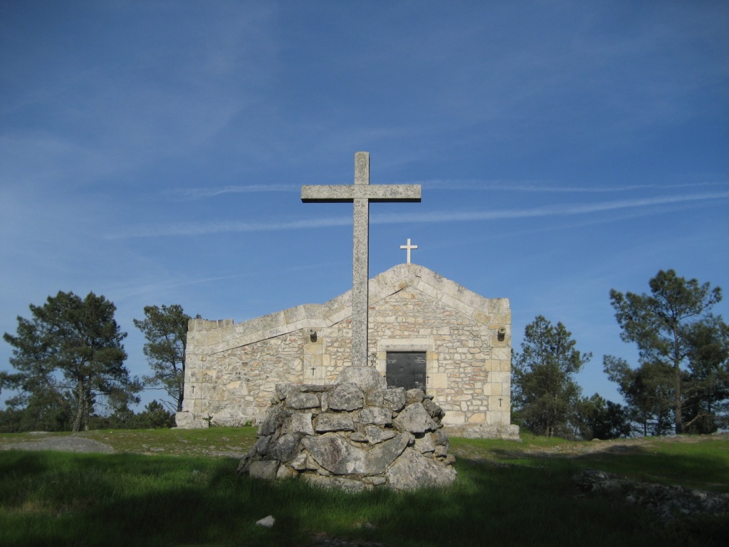
O acesso pode ser feito: a Norte, na EN16, vindo de Viseu, antes da povoação de Moselos virar à esquerda na estrada Municipal até ao ponto referenciado como parque; A Sul, a partir da EN337-1, vindo de Viseu, virar à direita em direcção a Travassós, S. Martinho de Orgens e apanhar a estrada Municipal até ao ponto referenciado como parque.
As caches( 2 caches small e 1 cache final regular) não estão escondidas na estrada, por isso não devem ser removidas as pedras da mesma.
O percurso a efectuar tem alguma extensão:
1- Quem deixar o carro no ponto indicado como parque, tem de percorrer cerca de 400m até ao início da via romana (esta distância pode ser evitada se tiver um veículo todo o terreno).
2- Entre o início da via romana e o fim da multicache são cerca de 600m com algum desnível (esta parte do percurso é proibida a veículos).

[EN]
Roman Road of the Crasto
According to some historians, Viseu will have been born of a crossing of 7 to 12 ways Romans. The Roman road of the Crasto consists of a set of pertaining relatively well conserved chunks from the way that conect Talábriga to Viseu or in a ampler boarding of the way that conect Emerita to Bracara (Mérida to Braga). the way is developed from East to West, from the city road and going up, with declivity accented, until the limits of the A24, passing underneath of this.
This secondary way connect Talábriga (near Águeda) to Viseu, important road knot, deriving from the Braga-Lisbon after the passage of the river Vouga. It followed for Talhadas where it has vestiges of the sidewalk, entering in Oliveira de Frades by Benfeitas, where a noticeable mile mark XXXI indicates the distance to Viseu that was thus Caput Viae (road knot; starting point for the counting of the miles). From here until Vouzela are known 5 mile marks. It followed to Bodiosa, Lobagueira, from above Couto, Crasto, Orgens and crossed the River Pavia, to Viseu, perhaps in the Bridge of the Azenha.
Adapted of http://viasromanas.planetaclix.pt
Chapel of Our Lady of the Crasto
The top of the Mount of the Crasto, to an altitude of 612 m, thus is called by in it having existed one ancient village fortified with thick braces of walls, certifying the presence human being in the ends of the Age of Bronze. In the interior of the walls, exists the dedicated Chapel to Nª Sr.ª of the Crasto whose origin if lost in the time. Concerning the chapel, Abbot de Miragaia says on the writings of the Mariano: "It is image of great devotion for the surrounding peoples, nominated for the women who have no milk for breast-feeding" and had a great brotherhood formed in 1588, with statutes approved for the Bishop D. Nuno de Noronha. To the front of the chapel a cruise exists and in its interior pictures with the life of Jesus, Nª Sr.ª do Crasto and S. Domingos.
Every year, in the Monday Easter, it is celebrated mass in this chapel, making a procession that leaves the First Church of Vil de Soito, passing for Quinta de Ferronhe and going up until the o top of the Mount of the Crasto.
Adapted of http://poives.home.sapo.pt/freguesia.html#Geograficamente
The Accesses and the Caches....
The access can be made: by North, in the EN16, coming from Viseu, before the village of Moselos turning the left in the city road until the point refered as park; by South, from the EN337-1, coming from Viseu, to turn the right direction to Travassós, S. Martinho de Orgens and to take the city road until the point refered as park.
Caches(2 caches small and 1 final cache regular) are not hidden in the road, therefore the rocks of the same one do not have to be removed.
The passage to effect has some extension:
1- Who to leave the car in the indicated point as park, has to cover about 400m until the beginning of the Roman way (this distance can be prevented with a vehicle 4x4).
2- Between the beginning of the Roman way and the end of multicache is about 600m (this part of the passage is forbidden the vehicles).