We have chosen to take you to three areas that show this active fault, all situated in Upper Hutt. We first take you to Harcourt Park in Upper Hutt. (Use the co-ords given). This park comprises 11.6 hectares of forested grasslands and it incorporates a rare example of a fault line displacing river terraces.
Secondly, at S 41° 06.497 E 175° 04.765, we take you to a nearby housing area that has had to build a double-width street to accommodate the fault which runs down the middle of it and across the nearby park.
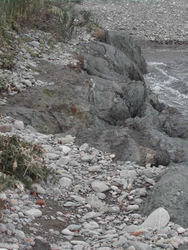
Lastly, at S 41° 08.178 E 175° 00.710, you will find a broken and shattered zone of the fault that is exposed in the Hutt River. Be careful here when it comes to parking, you will have to leave the main road (heading south) before you get to the site.
Earthquakes are an ongoing effect of the continuous recycling of tectonic plates. The outer 100km of the earth is divided into eight major plates and five significant smaller ones. These giant slabs move across the surface of the planet and are constantly being created at oceanic ridges and just a constantly destroyed at deep sea trenches. Most of the planet’s geological dramas, surface deformation and earthquakes are near boundaries between the plates.
New Zealand sits between the Australian Plate and the Pacific Plate, in fact the boundary splits the country, and the push-and-shove relationship between these two giant slabs of the earth’s crust has rocked and ruptured NZ for about 25 million years. Broadly speaking, the Australian plate is heading north while the Pacific plate is heading west. Only Northland is fully on the Australian plate, and only offshore islands like Chatham Island and Campbell Island are fully on the Pacific plate.
Wellington’s natural harbour formed as the sea flooded between two uplifted blocks of crust. Miramar Peninsula was probably an island 600 years ago, before an earthquake lifted the Kilbirnie area.
The Wellington fault begins off the southern coast of Wellington, separates the suburbs of Karori and Northland from Kelburn and Highbury, and continues past the city’s Botanical Gardens in Kelburn, through Thorndon, and then forms the western edge of Wellington Harbour.Further inland, the Hutt River flows down the depression and has filled the Lower and Upper Hutt areas with hundreds of metres of sediment. The fault follows the motorway (State Highway 2) and dominates the Hutt Valley. It then continues up through the Wairarapa, along the foothills east of the Tararua Range, to the Manawatu Gorge. (The geological continues however as the Mohaka Fault).
The Wellington fault presents a major hazard, as it goes through the heart of New Zealand’s capital city and is crossed by numerous bridges, roads and pipelines. Over 75% of people in the Wellington region live within 10 kilometres of the fault.
Wellington owes its distinctive landscape to this fault. During earthquakes along the fault, land along the north-western side of Wellington Harbour and the Hutt Valley moves upward, while in areas south-east of the fault land subsides.

Movement along the 75-kilometre-long segment of the Wellington Fault from Cook Strait through Wellington and the Hutt Valley to Kaitoke is considered likely to cause a major earthquake in the future. At least two earthquakes have occurred on this part of the Wellington Fault in the last 1,000 years, with the most recent about 400 years ago. During these earthquakes, sections of land on opposite sides of the fault moved past each other by about 4 metres. Such movement would produce earthquakes of the order of magnitude 7.5.
Large earthquakes on this section of the fault are estimated to occur about every 500 to 770 years.
If you are interested in learning more then try these two books: “Rocked and Ruptured – Geological Faults in New Zealand”, Jefley J.Aitken, and Plate Tectonics for Curious Kiwis” also by J J Aitken. Also the Institute of Geological and Nuclear Sciences Limited website: GNZ
Once you complete the following EarthCache requirements you can post your find without delay, as per the EarthCache guidelines. You will also need to verify your find by sending us a message with your answers to these questions and we will answer in due course:
1) Make sure you use the text "GC1C0A5 - The Wellington Fault" in your email
2) At the first GZ there are two wooden signs within the park that identify certain features related to the fault line. Find these and tell us what they say.
3) At the 2nd GZ, what is the name of the walkway that is nearby?
4) At the 3rd GZ, what is the manmade structure you can see south of the fault.
5) (optional) Also at the final GZ, take a photo of yourself with gps at the fault and post it with your log.
Please DO NOT post answers with your log. Just post your photo. :)