Aktuálně:
21.08.2022
CZ: Hlášena nečitelná S6 (E) a nenalezení finálky. Než se dostanu ke kontrole: E= A+D. Prosím případné další cachery o zjištění stavu finálky. Pokud tam opravdu není, "found" log found uznám, když mi pošlete přes Message Center vypočtené souřadníce finálky.
EN: Reported unreadable S6 (E) and final not found. Before I get there to check: E= A+D. Next cachers please check the status of the final stage. If the box is really missing, I will accept the "found" log when you send me the calculated coordinates of the final stage.
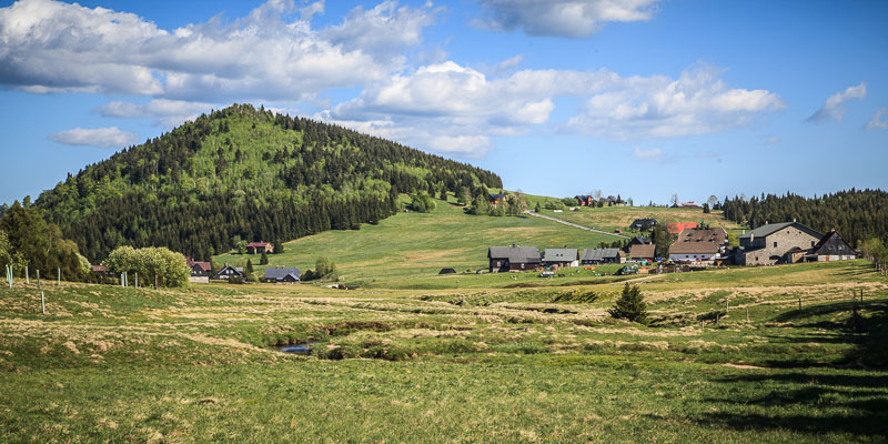
Tato mystery cache vás provede podél horního toku řeky Jizery, od svého prameniště na svahu nejvyšší hory českých Jizerských hor, Smrku, až k pomezí Jizerských hor a Krkonošm do Martinského údolí. Výlet lze absolvovat pěšky i na horském kole. Mezi Jizerkou a Karlovským mostem je úsek v délce cca 1,4km určen pro pěší, ale kolo tam lze převést. Trochu náročnější je úsek v okolí Hojerova domu, který vede po lesní cestě a je potřeba včas odbočit z asfaltky (za chatou Petrovka). Pěší si můžou úsek mezi S3 a S4 zpestřit přechodem přes Střední hřeben.
Tato mysterka navazuje na multicache Jizera, kterou je nutno absolvovat jako první a získat bonusové číslo. Samotná Jizera Bonus Cache představuje zhruba třicetikilometrový výlet. Obě keše dohromady tvoří náročnější dvoudenní pěší túru (případně pohodovou dvoudenní cyklistickou túru, případně náročnější jednodenní cyklotúru), v rámci níž vás čeká celkem necelých 70 km, ale také množství zajímavých míst a výhledů na české i polské straně hranice:
- ozubnicová železniční trať do Harrachova
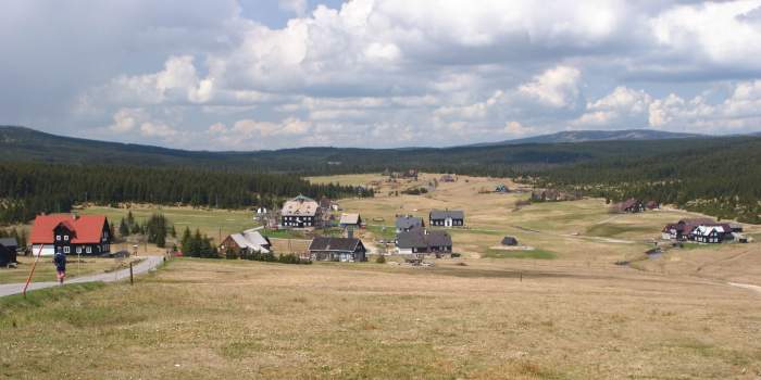
- Jizerka – nejvýše položená osada Jizerských hor
- šumící řeka pod Karlovským mostem, který je zároveň hraničním přechodem
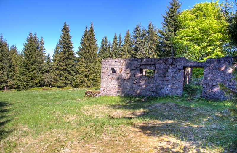
- kdysi sklářská osada Orle a ruiny osady Hala Izerska
- meandry řeky na Velké Jizerské louce
- velkolepý výhled z hory Stog Izerski (krátká odbočka z trasy multicache)
- nejvyšší hora českých Jizerek - Smrk
- prameniště Jizery
- vyhlídky ze Středního hřebenu Jizerských hor (jste-li pěšky)
- málo frekventovaná stezka mezi hřebenem a Jizerou, s ruinami pašerácké hospody Hojerův dům
EN: This mystery cache will lead you along the upper stream of Jizera river from its spring area, on the slope of Smrk, the highest mountain of the Czech part of Jizerske hory, down to the boundary between Jizerske hory and Krkonose, Martinske udoli. The trip can be undertaken on foot or on bike. There is section ca 1,4km between Jizerka and Karlovsky most which is designated for pedestrians but you can walk your bike through. A bit more difficult is the section around Hojeruv dum (=Hojer's house) which leads you along forest path and you have to turn off the asphalt road at right time (near Petrovka hut). The hikers can make the section between S3 and S4 more interesting if using the red trail over the Stredni hreben (=Central Ridge).
This mystery cache is a continuation of the multicache Jizera which must be discovered first to get the bonus number. Jizera Bonus Cache alone represents ca thirty-kilometre trip. Both caches together make a bit strenuous two-day hike (or an easy two-day biking trip, or a strenuous one-day biking trip), comprising almost 70 kms but also many interesting places and lookouts in both Czech and Polish side of the borderline:
- cog railway to Harrachov
- Jizerka – the highest settlement in the Jizerske hory
- white water stream under the Karlovsky bridge that is also the border crossing
- formerly glass-making settlement of Orle and the ruins of the village Hala Izerska
- meandering river on the Velka Jizerska louka (="Big Jizera Meadow")
- specacular view from the mountain Stog Izerski (short detour from the multicache route)
- the highest mountain of the Czech part of Jizerske hory - Smrk
- spring area of Jizera river
- lookouts from the Middle Ridge of Jizerske hory (if you walk)
- little frequented trail between the ridge and Jizera river, with ruins of the smugglers hut Hojeruv dum
Start
Cache má počátek v oblasti prameniště Jizery, na svahu hory Smrk Pokud navazujete na multicache Jizera, vracíte se do jejího startu. Pokud ji absolvujete samostatně, doporučuji nechat se odvézt k chatě Smědava (například cyklobusem na lince 540250 Frýdlant - Bílý Potok, Smědava).
EN: The cache starts in the spring area of Jizera, on the slope of Smrk mountain. If you follow-up after multicache Jizera, you will return to its starting point. If you undertake the trip as stand-alone, I recommend, let yourself drive to the Smědava hut (for instance on the bike-bus line No. 540250 Frýdlant - Bílý Potok, Smědava).
Doporučené trasy / Recommended trails
Vystačíte se svojí GPS a běžnou turistickou mapou. Pokud však chcete, můžete si stáhnout mapku s vyznačenými waypointy, které představují jednotlivé stages.
EN: You will do with your GPS and a ordinary tourist map. However, if you wish, you can download map with marked waypoints that represent all single stages.
Ubytování / Accommodation
Osada Jizerka je výborné strategické místo pro ubytování k odlovu této kešky. V cíli kešky (v Martinském údolí) bych doporučil chatu Sport-Ski, případně lze nalézt nocleh i v Kořenově.
EN: The Jizerka settlement is excellent strategic place for accommodation for this cache. Near the final of this cache (in Martinske udoli), I would recommend the Sport-Ski hut or alternatively you can find accommodation also in Korenov village.
|
Stages
(viz. waypointy / see waypoints)
Indicie: Na každé stage hledejte malý hliníkový štítek velikosti 5x3 cm, s uvedeným označením "JIZA". Indicie je číslo na tomto štítku. Všechny štítky jsou ve výši 175-200 cm, tedy odlovitelné i do určíté výše sněhové pokrývky.
Clues: Search for small alluminium tags, size 5x3 cm, with sign "JIZA". The clue is a number on the tag. All tags are in the hight of 175-200 cm, i.e. foundable also up to certain level of snow.
Stage 1: Prameniště Jizery (úvodní souřadnice / starting coordinates) = A
Stage 2: Předěl = B
Stage 3: Zelený kámen = C
Stage 4: Hojerův dům = H
Stage 5: Karlovský most = D
Pozor, na kterém místě hledáte (na druhé straně řeky je štítek pro cache Jizera)! / Make sure you search at the correct place (there is tag for cache Jizera accross the river)!
Stage 6: Orle = E
Stage 7: Kozinec = F
Stage 8: Mýtiny = G
I = první tři cifry z bonusového čísla (získáte tříciferné číslo) // first three figures from the bonus number (you receive a three-digit number)
J = poslední tři cifry z bonusového čísla (získáte tříciferné číslo) // last three figures from the bonus number (you receive a three-digit number)
Stage 9: FINÁLE / FINAL
N50°4X
E15°2Y
Z = součet indicií A až G (tedy bez H!) / sum of clues A to G (i.e. without H!)
X = [Z*H*B+I-F-B]/1000
Y = [Z*E+J+E*H-A*G+B]/1000
|

Praktické / Practicalities
Budete se pohybovat v Chráněné krajinné oblasti, tak buďte ohleduplní k životnímu prostředí. Celá trasa, s výjimkou posledních sto metrů vede po stezkách a cestách.
Jizerské hory jsou krásné, ale tak jako v každých horách, počasí může nepříjemně překvapit nepřipravené. Takže pořádné boty, pláštěnky, teplé oblečení a „energii sbalenou na cesty“ s sebou v každé roční době.
Osada Jizerka je výborné místo pro pauzu pro unavené svaly a občerstvení v některé s horských chat.
Pro případ nouzove konzultace ponechávám v listingu telefonní kontakt: +420 731 570 405.
EN: You will pass hike/bike through the National Reservation so be careful with the environment. The whole route except last hundred metres leads along the trails and roads.
Jizerske hory are beautiful but, as in every mountains, the weather can unpleasantly surprise the unprepared ones. So, sturdy boots, rain coats, warm clothes and energy-food packed with you at all times.
The Jizerka settlement is a great place for a break for the tired muscles and a refreshment in one of the mountain huts.
I leave a phone contact in the listing for the case of emergency consultancy: +420 731 570 405.

Historie kešky / History of the cache
2-3.5.2008 příprava kešky
18.5.2008 publikace
16.2.2010 změna indicie a výpočtu finálky kvůli novým rozcestníkům
18-19.5.2012 trasa projeta na kole, údržba finálky.
20.5.2012 upgrade kešky na indicie formou štítků. Změna výpočtu finálky, sjednocení cyklo a pěší trasy, změna trasy mezi Stages 5 a 7 (přemístěna Stage 6), přidán GeoChecker.
15.6.2013 oprava štítku na S3.
5.8.2013 přidán Flag counter do listingu.
30.8.2014 oprava štítku na S3 a S5
27.5.2017 projetí trasy, oprava stages, přidání indicie H (nová Stage 4) a přesun Stage 3
7.6.2017 aktualizace listingu
7.7.2019 oprava štítku na S8