
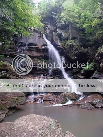
Big Bradley Falls
Big Bradley Falls is located just off of Holbert Cove Road - in Saluda, North Carolina.
The posted coordinates will get you to the base of the falls which is a 3/4 mile hike. I have also provided a set of parking coords.
The trail at the parking area first enters a field - From here, the trail enters the woods, goes up a small rise, bears to the right and heads towards Cove Creek.
It then crosses the creek on some rocks and heads uphill.
If the water level is up, you may not be able to cross without getting your feet wet.
At about 3/4 of a mile or so, a side trail bears to the left and downhill, and the main trail heads on to a view from an overlook.
Keep going and take the 2nd trail to the left to get a different view. The only problem is you can't see the main part of the falls from this vantage point. It's hidden behind a tree.
Getting to the base requires a steep descent with the help of a rope.
Go back to where the trail split and take the right trail down.
It splits - left goes to the top of the falls, right goes to towards the base. The best and I think only way down is a 25-30' climb down a rock face to the bottom.
There's a rope attached and it looks like it's fairly unsafe to use. I usually carry a 25' section of rope on all hikes just because you never know, and we used it to lower some of our packs down.
The wall has plenty of foot holds and the rope has knots for hand holds, so the descent isn't really that bad.
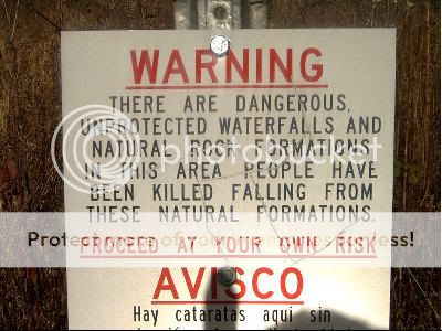
This waterfall is active year round. Be sure to bring along a bottle of water and do not attempt alone.
Also remember to bring along your camera as you will want some keep-sake pictures of the waterfall and the surrounding area.
The Geological Formation of a Waterfall
Typically, a river or a stream in this case, flows over a large step in the rocks which may have been formed by a fault line.
Over a period of years, the edges of this shelf will gradually break away and the waterfall will steadily retreat upstream, creating a gorge of recession.
Often, the rock stratum just below the more resistant shelf will be of a softer type, meaning undercutting, due to splashback, will occur here to form a shallow cave-like formation known as a rock shelter or plunge pool under and behind the waterfall.
Eventually, the outcropping, more resistant cap rock will collapse under pressure to add blocks of rock to the base of the waterfall.
These blocks of rock are then broken down into smaller boulders by attrition as they collide with each other, and they also erode the base of the waterfall by abrasion, creating a deep plunge pool.These Particular falls are made from Slate rock and Limestone which are very common in the Blue Ridge Mountain System.
Classification of Waterfalls...
Block
A waterfall in a Block form occurs over a wide breadth of the stream. The waterfall must be wider than it is tall. A waterfall with this form does not have to be a solid sheet of water across it's entire width.
Cascade
A waterfall of a Cascade form descends over, gradually sloping rocks, a series of small steps in quick succession, or a rugged sloping surface of some kind. Cascades can be both gradual and steep.
Curtain
Curtain waterfalls occur along a wide breadth of stream where the falls must be taller than it is wide. A waterfall of this form often becomes narrower in low discharge periods.
Fan
Waterfalls of a Fan form occur when the breadth of the water in the waterfall increases during it's decent, causing the base of the falls to appear much wider than the top of the falls.
Horsetail
Horsetail waterfalls are characterized by the constant or semi-constant contact the water maintains with the bedrock as it falls. Horsetail waterfalls can be almost vertical, as well as very gradual.
Plunge
The classic and overly cliched waterfall form, where the water drops vertically, losing most, or all contact with the rock face. This waterfall form has also been referred to as a "Cataract" and a "Vertical" form waterfall.
Punchbowl
Punchbowl waterfalls, coined from the famous Punch Bowl Falls in Oregon, occur where the stream is constricted to a narrow breadth and is forcefully shot outward and downward into a large pool.
Segmented
Segmented waterfalls occur where the stream is broken into two or more channels before descending over the cliff, causing multiple falls to occur side by side.
Slide
Similar to a cascade, a Slide type waterfall descends a smooth, gradual bedrock surface. Slide waterfalls maintain constant contact with the bedrock, and are often associated with the granitic family of bedrocks.
Tiered
Tiered waterfalls are characterized by multiple distinct drops in relatively close succession to one another. Whether or not a waterfall with two visible drops counts as a tiered waterfall is up to the beholder. I typically require tiers to be visible together and within a given distance of each other.
Logging Requirements…
1) How high or tall do you estimate the waterfall to be?
2) How wide do you estimate the waterfall to be?
3) Using the waterfall classification guide above, what classification of waterfall do you believe the waterfall is?
4) Take a picture of yourself and your GPS with the waterfall in the picture from any angle and post it in with your online log.
People have lost their lives at this location in the past. Be very careful and do not take any unnecessary chances.
Please do not put yourself in any danger trying to meet these logging requirements.
I request that you email your answers to me on the same day that you log your “found it” log. (This does not have to be the day you visit, just the day you log the find on the computer.) I also request that you do not log a “found it” log unless you have actually visited the site of the earthcache and sent the answers to me. The only person who really benefits from your visit is YOU.
Each cacher is required to send the required information and not rely on another cacher to provide it. Failure to follow this procedure will result in a deleted log. It is not my job to keep track of your group.
XXXXXXXXXXXXXXXXXXXXXXXXXXXXXXXXXXXXXXXXXXXXXXXXXXXXXXXXXXXXXXXXXXXXXXXXXXX
We became Platinum Earthcache Masters on September 17, 2007.
We were the first to request and receive on July 2, 2011 the Emerald Discovery Award for finding 500 or more Earthcaches.
We received the Diamond Discovery Award on June 17, 2012 for finding 1,000 or more Earthcaches.


XXXXXXXXXXXXXXXXXXXXXXXXXXXXXXXXXXXXXXXXXXXXXXXXXXXXXXXXXXXXXXXXXXXXXXXXXXXXXXX
