Cumberland Island is Georgia's largest and most southern barrier
island. The island is now protected as a national seashore. To get
credit for this EarthCache, you must visit the island and walk the
3 1/2 mile Dungeness Trail to the Sea Camp dock.
Cumberland Island is only accessible by boat. Most people arrive
on the ferry from St. Mary’s. To prepare for your visit you should
go to the visitor center in St. Mary’s and make your ferry
reservation at the nearby ferry office. Check out the website for
more information:
http://www.nps.gov/cuis/planyourvisit/placestogo.htm. Camping is
available, but we opted for the popular day trip.
There are only 300 people allowed on the island at one time, and
the ferry reservations could be difficult to obtain in the busy
season.
We each took a backpack loaded with our lunch, water, rain gear
and snacks. Remember to take a camera, and you will want insect
repellant. Be sure to wear comfortable shoes. You may want to take
a bag for collecting beach treasures and empty seashells.
You will arrive on the island near the beginning of the
Dungeness Trail and walk the trail through a maritime forest, the
historic district and along a grassy salt marsh. From there walk
along the beach for a little over a mile to Sea Camp where the
ferry will meet you for your return trip. We were lucky enough to
view a slide presentation by the ranger at Sea Camp.
Geologic History of Cumberland Island
Cumberland Island's formation began about 40,000 years ago during
the "Ice Ages" of the Pleistocene Epoch. During that time the sea
level changed as the glaciers advanced and retreated. Each time
there was a constant sea level, a shoreline of barrier islands and
marshes formed.
The growth of the Pleistocene glaciers resulted in the lowering
of the sea level throughout the world. Cumberland Island and its
adjacent salt marshes were left high and dry as the seas withdrew
for thousands of years.
The Holocene Epoch, around 11,000 years ago, saw the retreat of
continental ice sheets which caused the sea level to rise.The
Holocene portion of Cumberland was formed a short distance seaward
of the existing shoreline. In time, wave action attached the sands
of the Holocene island chain onto the already existing Pleistocene
barrier island chain.
Throughout Cumberland Island's geologic history, it has
constantly changed due to erosion, deposition and biologic growth.
In relation to geologic time the island is very young and
unstable.
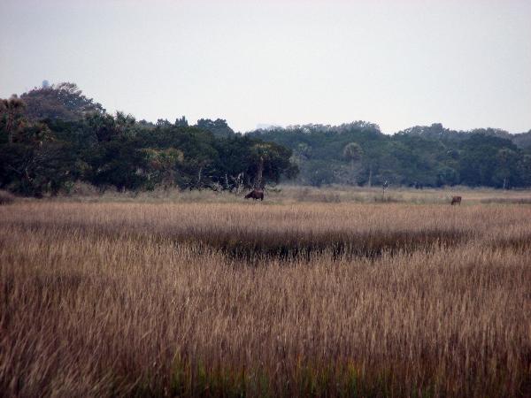
Salt Marsh
Salt marshes are found in protected waters behind barrier
islands or within estuaries (where fresh water meets ocean water).
Marsh sediments are fine-grained silts and clays, and the
vegetation is composed of salt-tolerant plants.
The high marsh area is seen in the picture below. Deer and feral
horses graze in the high marsh.
In the low marsh, mudflats and oyster reefs are exposed at low
tide. Salt marshes are reponsible for more than 80% of all edible
sea-life which is hatched in these "nurseries." Also, organic
matter from the marshes, washed out by the tides, feeds ocean
fish.
 As you approach the boardwalk through the salt marsh you will
arrive at the cache location. Here you will gain information needed
to answer the 3 questions in order to get credit for this
EarthCache.
As you approach the boardwalk through the salt marsh you will
arrive at the cache location. Here you will gain information needed
to answer the 3 questions in order to get credit for this
EarthCache.
The salt marsh changes drastically with the tides. When the tide
is in the tops of the grasses move with the water hiding the
movement of life below. When the tide goes out, the mudflats are
visible revealing shellfish and crabs scurrying around in search
for food. Raccoons and other animals may also appear in their
search for food.
The tides are very important to the life of the marsh, bringing
nourishment which the marsh inhabitants need. As the tide recedes
it washes silt and debris out to sea.
The salt marsh supports populations of fish, shellfish, birds
and other animals. It also provides protection for the young of
many species from predators.
The marshes protect the landward side of the island from the
tidal flow and also absorbs much of the impact of storms. In
return, the island protects the marsh from ocean storms.
Living Mud
Please email me the answers to the following questions from the
information found at the cache location. Don't post the anwers in
your log.
1.How many times a day does the seawater cover the mudflats?
2.Where is most of the action in the salt marsh?
3.What feature of the island protects the marsh from storms?
Enjoy the rest of your walk and the many treasures Cumberland
Island has to offer.

Silver EarthCache Master