 Cascade Locks - Mustill Store by Don Getz (with
permission)
Cascade Locks - Mustill Store by Don Getz (with
permission)
This earthcache is pinned to the canal towpath
in the center of the Cuyahoga Valley National Park on the
geocaching map but it is meant to be completed anywhere in the 13
counties along its entire canal and towpath route from Cleveland to
Portsmouth so that all Ohio history enthusiasts and towpath hikers
and riders can participate in this cache. Only the locally-mined
sandstone blocks of the canal locks have stood the test of time
although the canal bed or towpath is still evident along most of
its route. In some sections the canal is actually still filled with
water and resembles the canal as it may have once appeared back in
the early 1900's.
The purpose of this earthcache is to take the cacher on a short
trip along the route of the historic canal route by selecting a
canal lock to visit while also examining the sandstone for the
earthcache aspect. You'll find that the canal locks have been
numbered from the highest points at the Portage Lakes in Akron and
Buckeye Lake near Hebron down toward the lowest points at Lake
Erie, at the Ohio River, and in the central valley near Dresden.
You'll also notice that waters north of Akron flow northward toward
Lake Erie whereas waters south of Akron flow south toward the Ohio
River due to a ridge through northern Ohio called the St. Lawrence
River continental divide.
|
CITY
|
LOCK
|
LATITUDE
|
LONGITUDE
|
CONDITION
|
|
| Cleveland |
44 |
N41-29.734 |
W081-42.114 |
* H |
|
40 |
N41-25.150 |
W081-36.644 |
** |
|
39 |
N41-23.409 |
W081-37.488 |
**** |
|
38 |
N41-22.353 |
W081-36.769 |
***** H |
|
37 |
N41-21.407 |
W081-35.819 |
*** H |
| Brecksville |
36 |
N41-19.378 |
W081-35.184 |
* |
| Chafee |
35 |
N41-18.625 |
W081-34.913 |
*** |
|
34 |
N41-17.355 |
W081-33.871 |
**** |
| Boston |
33 |
N41-16.567 |
W081-33.636 |
* |
|
32 |
N41-15.927 |
W081-33.527 |
*** |
|
31 |
N41-15.107 |
W081-32.752 |
** |
| Peninsula |
30 |
N41-14.729 |
W081-33.246 |
*** |
|
29 |
N41-14.565 |
W081-33.020 |
***** H |
|
28 |
N41-13.962 |
W081-33.112 |
***** |
| Everett |
27 |
N41-12.277 |
W081-34.252 |
*** |
|
26 |
N41-11.128 |
W081-34.866 |
*** |
| Botzum |
25 |
N41-10.544 |
W081-34.776 |
*** |
|
24 |
N41-10.334 |
W081-34.679 |
** |
| Cascade Valley |
18 |
N41-06.021 |
W081-31.665 |
**** |
|
17 |
N41-05.825 |
W081-31.560 |
*** |
|
16 |
N41-05.617 |
W081-31.220 |
* |
|
15 |
N41-05.522 |
W081-31.086 |
***** H |
|
14 |
N41-05.448 |
W081-31.068 |
* |
|
13 |
N41-05.417 |
W081-31.067 |
* |
|
12 |
N41-05.367 |
W081-31.090 |
* |
|
11 |
N41-05.309 |
W081-31.151 |
* |
|
10 |
N41-05.251 |
W081-31.135 |
* |
| Akron |
3 |
N41-04.816 |
W081-31.277 |
** H |
|
2 |
N41-04.734 |
W081-31.386 |
***** H |
|
1 |
N41-04.603 |
W081-31.440 |
* |
| Clinton |
2 |
N40-56.154 |
W081-37.581 |
*** |
|
3 |
N40-56.078 |
W081-37.628 |
** |
| Canal Fulton |
4 |
N40-52.653 |
W081-35.017 |
***** |
| Bolivar |
7 |
N40-37.674 |
W081-27.170 |
* |
|
8 |
N40-37.549 |
W081-27.009 |
* |
| Zoar |
9 |
N40-37.413 |
W081-26.810 |
* |
|
10 |
N40-36.710 |
W081-25.963 |
* |
|
11 |
N40-32.864 |
W081-25.539 |
* |
| Lockport |
13 |
N40-28.604 |
W081-26.617 |
**** |
|
14 |
N40-27.149 |
W081-25.131 |
** |
| Tuscarawas |
15 |
N40-23.559 |
W081-24.483 |
***** |
|
16 |
N40-23.453 |
W081-24.681 |
* |
|
18 |
N40-18.227 |
W081-32.434 |
* |
| Newcomerstown |
22 |
N40-16.423 |
W081-37.558 |
* |
| Orange |
25 |
N40-17.556 |
W081-47.099 |
** |
| Roscoe Village |
26 |
N40-17.035 |
W081-52.651 |
**** H |
|
27 |
N40-17.150 |
W081-52.462 |
**** H |
| Adams Mills |
29 |
N40-09.445 |
W081-56.697 |
**** |
|
30 |
N40-09.380 |
W081-56.949 |
*** |
| Dresden |
31 |
N40-07.061 |
W082-00.187 |
**** H |
|
32 |
N40-07.040 |
W082-00.150 |
**** H |
|
33 |
N40-07.014 |
W082-00.110 |
*** H |
| Frazeysburg |
18 |
N40-09.136 |
W082-02.355 |
* |
| Nashport |
16 |
N40-03.341 |
W082-13.311 |
*** |
| Newark |
13 |
N40-03.957 |
W082-18.054 |
* |
| Heath |
1 |
N40-00.818 |
W082-27.412 |
*** H |
| Baltimore |
8 |
N39-50.208 |
W082-37.467 |
*** |
| Lockville |
11 |
N39-49.038 |
W082-44.184 |
**** H |
|
12 |
N39-49.116 |
W082-44.301 |
*** |
|
13 |
N39-49.208 |
W082-44.415 |
** P |
|
14 |
N39-49.296 |
W082-44.544 |
**** P |
|
15 |
N39-49.348 |
W082-44.613 |
* P |
|
16 |
N39-49.383 |
W082-44.681 |
*** P |
|
17 |
N39-49.524 |
W082-44.911 |
*** P |
|
18 |
N39-49.753 |
W082-45.281 |
** |
| Groveport |
22 |
N39-51.268 |
W082-52.367 |
**** |
| Lockbourne |
26 |
N39-49.164 |
W082-57.654 |
**** H |
|
27 |
N39-48.788 |
W082-57.844 |
*** |
|
29 |
N39-48.667 |
W082-58.012 |
*** |
|
30 |
N39-48.628 |
W082-58.284 |
*** H |
| Ashville |
31 |
N39-42.565 |
W082-58.392 |
*** P |
| Chillicothe |
41 |
N39-15.791 |
W082-55.039 |
*** |
|
42 |
N39-15.755 |
W082-55.010 |
*** |
| Waverly |
44 |
N39-07.532 |
W082-59.297 |
** H |
| Coopersville |
48 |
N38-50.762 |
W083-01.042 |
**** H |
| Rushtown |
49 |
N38-49.776 |
W083-01.117 |
**** |
| Union Mills |
50 |
N38-45.000 |
W083-01.689 |
*** |
| Portsmouth |
55 |
N38-43.553 |
W083-01.878 |
* |
* = Poor Condition or Very Distant
** = Degraded Condition
*** = Average Condition
**** = Above Average Condition and Reasonably Convenient
***** = Excellent or Fully Functional Condition and Convenient
Of the original 146 locks, 78 can still be
located and recognized as locks for this earthcache! I would
consider those sites indicated with an “H” to be
handicapped accessible with safe adjacent parking and those with a
"P" are on private property requiring verbal permission for access.
(Most lock owners are happy to allow visitors.) I took each of
these 78 fixes while standing on the locks so I know that they're
accurate!!!
 A Canal Lock in Roscoe Village
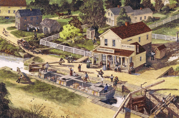
When the Ohio and Erie Canal was finally
completed it was over 308 miles long and used 146 locks to raise
the canal boats over hills and to lower the canal boats into
valleys. Dug entirely by hand, the canal bed took a decade to dig
in its entirety. When completely filled, the canal bed was 40 ft
wide across the surface, and only 4 ft deep. The locks used to lift
the boats in the northern areas of Ohio were made primarily of
Berea grit or Amherst sandstone blocks lined with timber planks. In
the south, the finer grit Waverly sandstone was more readily
available. A sandstone block quarry can be explored at Deep Lock
Quarry Metro Park when visiting the Peninsula Lock 28 site to see,
first hand, how the massive blocks were cut and moved. The canal
boats could haul 10 tons of passengers or cargo, but were limited
to a top horse-drawn speed of 4 MPH to help prevent the banks from
eroding down into the canal basin and grounding the boat
traffic.
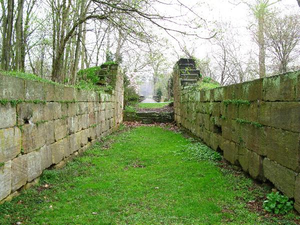
Since its demise, most of the canal banks have
been weathered away or the canals have been filled and replaced by
railroad tracks although the sandstone blocks of the canal locks
remain as monuments to Ohio's early commercial transportation.
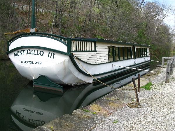 Monticello III
During the profitable years over 1,000 canal
boats carried on their trade along the canal and new towns were
born along the way. Two canal boats, the St. Helena II in Canal
Fulton and the Monticello III in Roscoe Village near Coshocton are
still in operation giving passenger rides throughout the summer
months.
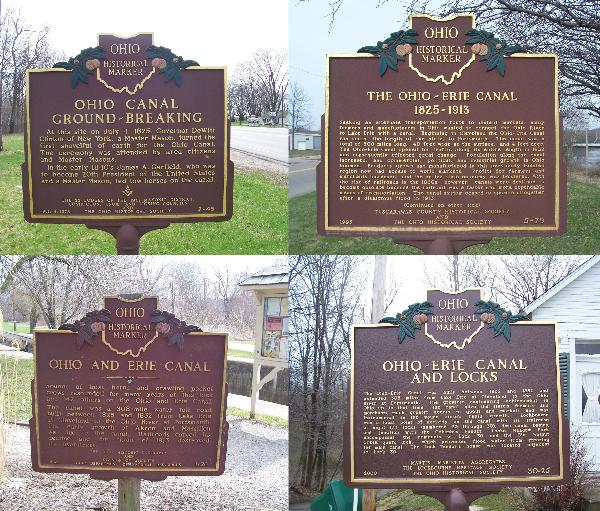 Historical Signs
To claim this earthcache, please complete
Items #1 and #2, below.
(1) Take a picture of yourself or your GPS near any 1 of the
78 listed canal locks clearly showing the lock in the foreground or
background.
(2) At any lock, find what you consider to be an average
sized block and measure its length, width, and height, in inches.
Multiply the length x width x height and divide this number by
26,417 to convert the dimensions into volume and then through
density into tons. Post the city and number of the lock that
you photographed and the weight of the block that you selected.
Extra pictures are encouraged.
THIS EARTHCACHE WAS PLACED BY
A
PLATINUM EARTHCACHE
MASTER