 For 100 years, the National Park Service has preserved America’s special places “for the enjoyment, education, and inspiration of this and future generations.” Celebrate its second century with the Find Your Park GeoTour that launched April 2016 and explore these geocaches placed for you by National Park Service Rangers and their partners.
geocaching.com/play/geotours/findyourpark
Why climb Bearfence Mountain? Hikers consider it one of the prettiest spots in the entire park. The short but moderately strenuous hike takes you through an interesting chapter of the geological history of the Blue Ridge Mountains. And now it's an Earthcache!
The geologic story of Shenandoah National Park began 1.2 billion years ago, during an ancient mountain building event. Molten magma, miles beneath the earth's surface, slowly solidified to become the "basement rock," or core, of what we now call the Blue Ridge Mountains. For the next 600 million years, erosion of the ancient mountain range exposed the granitic basement rock. When continental rifting began about 570 million years ago, the rifting of the earth's crust formed deep cracks in the granite which led to volcanic activity. For centuries, molten basaltic lava burst forth and poured over the land, forming a smooth, flat plain called the Catoctin Formation. The cooling and contraction of the lava produced a network of polygonal cracks, or columnar jointing. As the rifting continued, a broad, shallow depression formed from Alabama to Newfoundland. For the next 300 million years, an ancient ocean (the Iapetus Ocean) flooded the area that is now the Appalachian Mountains. Layers of water-borne sediments accumulated on the ocean floor, followed by limestone sediments composed of limy mud and fossilized marine shells. Three hundred million years ago, the Iapetus Ocean closed, resulting in a major collision between the North American, African, and European continents. The rocks became metamorphosed under the great heat and pressure that occurred when the continents collided. The collision of the earth's tectonic plates caused the older, underlying layer of metamorphic rock to be thrust upward and slide over the younger layer creating a towering mountain range that we call the Appalachians.
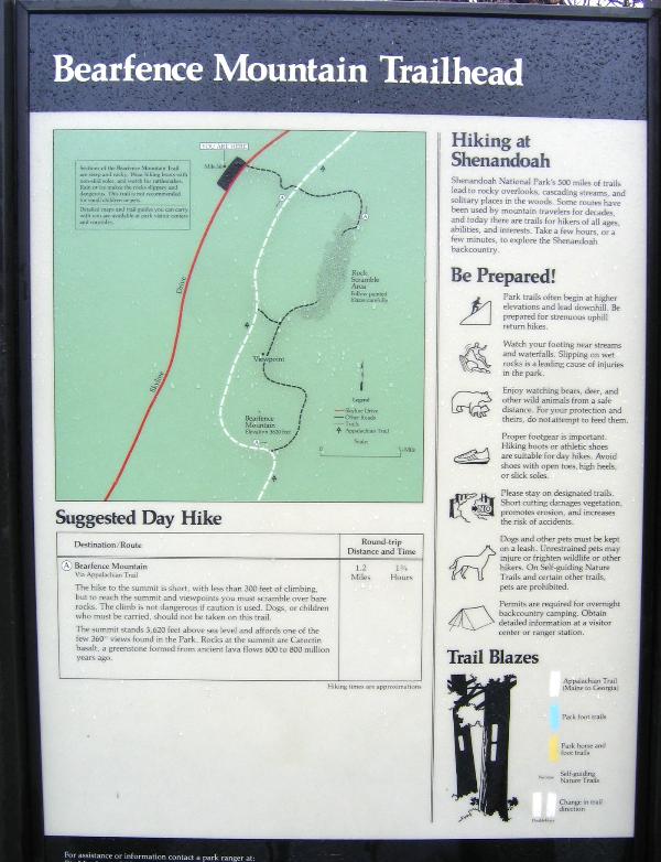 As you start up the Bearfence Mountain trail from the parking area (Mile Post 56.4), you'll see a low, flat boulder on each side of the trail about 60 yards from Skyline Drive. Both are conglomerate of the Swift Run Formation, a discontinuous unit of arkosic sandstone, and conglomerate and phyllitic mudstone exposed below the metabasalts of the Catoctin Formation. Bearfence Mountain is surrounded by Swift Run sandstone. "Sandy phyllite, conglomerate, and quartzite of the Swift Run Formation are exposed long the first 400 feet of the trail. At the beginning of the trail, tan, thinly bedded, sandy phyllites are exposed. The "rock scramble" is several hundred yards of metabasaltic flows and volcanic breccias of the Catocin Formation. Early in the scramble, you can see some columnar-jointed metabasalts lying on their sides, oriented between 20 and 45 degrees from the horizontal." Reference: Badger, Geology Along Skyline Drive, p. 55-56.
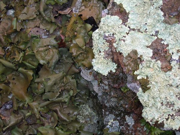 "About halfway to the summit, (approximately 20 yards past the intersection with the Appalachian Trail) you cross the contact between the Swift Run and Catoctin Formations. On the blazed trail, they are separated by a very thin layer of quartz pebbles. The rocks are weathered and lichen-covered, which makes them hard to identify. But at several places you can see where the advancing lava picked up pebbles, sand, and mud. Elsewhere you can see veins of quartz and epidote." Shenandoah National Park and Skyline Drive, p. 175-176
"Perhaps the most unique rocks in Shenandoah National Park are the greenstones, old lava flows that now cap many of the highest peaks in the park. The lavas were originally composed of basalt, a black volcanic rock similar to those found in Hawaii and Iceland today. The rocks in Shenandoah, however, are now various shades of grey and dark green, and have several minerals and textures that are not normally found in basalt. It turns out that these rocks were metamorphosed, meaning their minerals and textures changed under conditions of great heat and pressure. In this case, the formation of the Appalachian Mountains created the appropriate conditions, and new minerals such as chlorite and epidote grew within the old basalt. These new minerals gave the rock a greenish color, so that today it is called greenstone." Reference: Shenandoah National Park website (www.nps.gov/shen) Excellent exposures of greenstone can be found at the summit of Bearfence Mountain.
"Shenandoah's greenstone lava flows can have many different appearances. They often appear as jagged cliffs, or steep fields of angular grey boulders. In general, the rocks are very fine-grained, so that individual minerals can rarely be seen. On a freshly broken face, the rocks look dark grey to dark green, but more weathered and eroded surfaces often appear light grey or rust-red. In many cases the rocks appear to contain many thin layers tilted at a sharp angle, producing an uneven, jagged look; this is a metamorphic texture called "cleavage", formed by deformation and the growth of the mineral chlorite.
The greenstones also contain several very unique and interesting geologic features. The first is columnar jointing, a fracture pattern that forms as liquid basalt flows cool and solidify.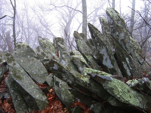 Another feature of the greenstones is found between some individual lava flows. Here you may find a rock composed of fragments of other rock mixed together. As new lava flows advanced across older, solidified flows, they often ripped up the surface of the older flow, as well as any sediments that may have been deposited by short-lived rivers. Thus, the boundary between flows is often marked by a chaotic layer of mixed-up rock fragments and sediments that has a very distinct appearance. This type of rock is known as "breccia", and in Shenandoah, it generally contains an eye-catching blend of colors including lime green, dark purple, and white. This breccia is often found as loose rocks on the flat "benches" separating cliffs of different lava flows." Reference: Shenandoah National Park website (www.nps.gov/shen)
Also on the summit, you will see tors, a type of rock outcrop formed by weathering. The balanced rocks, as well as chimneys and spires, are typical of periglacial tors. These are the product of intense weathering and denudation characteristic of conditions imposed by a periglacial climate during the late Pleistocene Epoch in the Blue Ridge. As the weathering of the tors continues, the rock is broken down into ever smaller sizes. Many hillsides are covered with loose rocks, known as talus, which have provided ready building materials for thousands of years. Eventually the granite is weathered down to a level equivalent to sandy gravel, which consists of individual crystals.
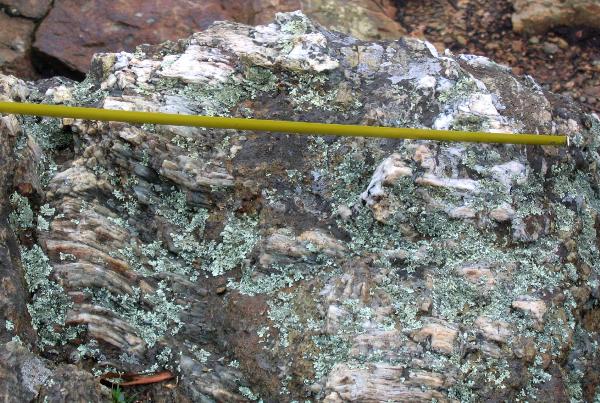 "Amygdules are also quite evident at Bearfence Mountain. These were gas vesicles within the metabasalts that filled with quartz, epidote, feldspar, and/or hematite . This type of amygdule is abundant in the volcanic breccias on Bearfence Mountain. However, there are some other amygdules in the metabasaltic flows near the summit that are filled with chlorite. These appear as dark green or black blotches in a lighter gray metabasalt. This is one of the few locations in SNP where this type of amygdule can be observed." Reference: Badger, Geology Along Skyline Drive, p. 57-59.
In order to log this Earthcache, you must fulfill these requirements. Do not post information in your log (it will be deleted). E-mail your answers to us:
1) At N 38* 27.079 W 078* 27.910, you will find some columnar-jointed metabasalts lying on their sides, oriented between 15 and 20 degrees from the horizontal . In what direction (N/S/E/W) do their tops point?
2) On the summit, find the quartz and feldspar amygdule at N 38* 26.981 W 078* 27.935 (same as the posted cache coordinates), and measure its diameter. A photo of the amygdule is above and below.
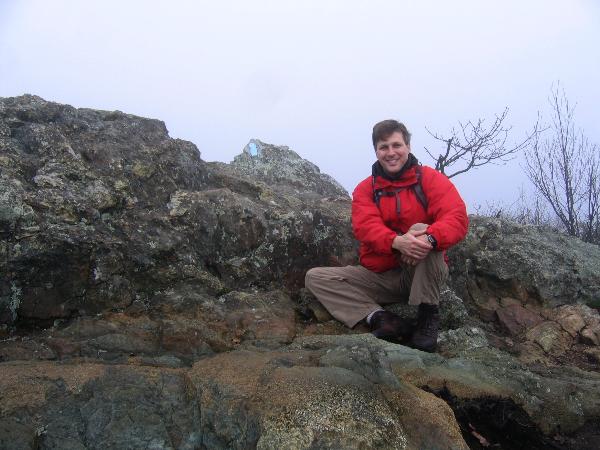
3) Post or e-mail a photo of your group on the summit, sitting by the amygdule with the blue trail blaze behind you, as pictured below.
References:
Geologic Formations of Shenandoah National Park
Badger, Robert, 1999, Geology Along Skyline Drive, 100 p.
Heatwole, 1988, Guide to Shenandoah National Park and Skyline Drive, 226 p.
Here is a wonderful link from the Northern Virginia Community College on the Geology of Shenandoah National Park
Here is a great resource for information and maps of Bearfence Mountain