Earthquakes have plagued mankind for millennium. The cost
in terms of human life and damages to property, earthquakes rank as
one of the most destructive forces on Earth. In 1906, an
earthquake struck the booming metropolis of San Francisco,
California and brought attention to one particular fault line
running through the Bay Area: The San Andreas Fault.
The San Andreas Fault is certainly not one of the longest faults
in the world, but it does run through some of the densest populated
regions of the world. Stretching from the North San Francisco
Bay in the North, all the way to nearly San Bernardino to the
South, millions of Californians wait in breathless anticipation of
the next Big One.
The United States Geological Survey is the government agency
charged with monitoring and predicting earthquakes in the United
States. By the late 1970's the scientists of the USGS began
to see a pattern of predictable earthquakes near a small little
town along the San Andreas Fault in Central California, and they
began to study the area with intense interest. By 1985, the
USGS had set up a small field office in the town, and began
deploying state of the art sensors in the area. Most of these
sensors are deployed on private ranch land in the area, but you can
glimpse a handful of the stations from the road that runs to
the North and South of Parkfield.
So why all the interest in this area? Well, the USGS saw a
pattern of earthquakes that seemed to hit the area, almost like Old
Faithful in Yellowstone, which appeared to be reliably timed every
20 years, that were intense enough (magnitude 6.0 or greater),
that with enough data could possibly help to unlock some of
the mystery of how, why, and where the next earthquake may
strike....maybe even the next Big One. The explanation of all this
interest cannot be better stated than from the USGS Parkfield
page:
Moderate-size earthquakes of about magnitude 6 have occurred
on the Parkfield section of the San Andreas fault at fairly regular
intervals - in 1857, 1881, 1901, 1922, 1934, and 1966. The first,
in 1857, was a foreshock to the great Fort Tejon earthquake which
ruptured the fault from Parkfield to the southeast for over 180
miles. Available data suggest that all six moderate-sized Parkfield
earthquakes may have been "characteristic" in the sense that they
all ruptured the same area on the fault. If such characteristic
ruptures occur regularly, then the next quake would have been due
before 1993.
As it turned out, the expected 1993 Parkfield quake was nine
years late. On September 28, 2004, the long anticipated
Parkfield quake hit, and the USGS was there to capture the moment.
The magnitude 6.0 quake struck a mere 7 miles SW of the town of
Parkfield, rupturing primarily to the Northwest along the San
Andreas Fault which runs along the valley that the town of
Parkfield sits in. There were no reports of injuries or
damage, the tiny little Parkfield school closed for the day, and
the San Luis Obispo County Office of Emergency Services had the
opportunity to test out its Emergency Response Network. After
a day or two, life went on as normal. Children returned to
school, and the residents of Parkfield had something to talk about
with the occasional tourist that came through town to see the
"Earthquake Capital of the World".
For the USGS, however, it was a veritable gold mine of data that
is still being discussed and written about four years later.
To Claim a Find on this Earthcache:
To cut to the quick on this Earthcache, lets get down to the
requirement to claim a Find on this Listing. I'm not
particularly fond of email verification methods so I've devised a
verification requirement with a twist.
There are only a few visible clues in the area that give any
indication that one of the most notorious fault lines in the world
runs through this region. Besides the USGS field office,
which only concedes to the public interest by posting a few facts
and maps on a bulletin board outside its fenced in work yard, the
only other obvious feature related to the 2004 quake is the minor
damage to the bridge to the South of town. While certainly an
interesting byproduct of the quake, the parking situation is kind
of sketchy, and the thought of people traversing the barely two
lane bridge for a photo opportunity sent chills down my spine.
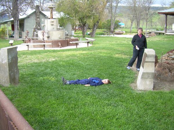
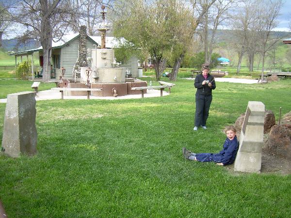
Therefore, the coordinates above will instead, take you to a
small little park adjacent to the Parkfield Inn, where a small
commemorative monument is set up to illustrate the distance the San
Andreas Fault has moved since 1931.
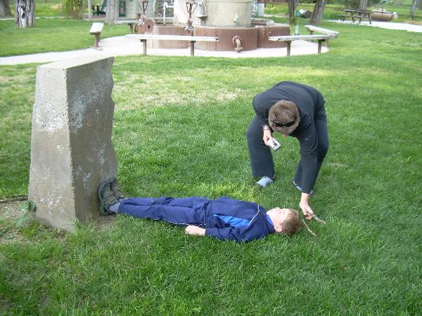
Your job is to measure the distance between these two markers
by any method available to you. You are to devise your own
measuring instrument, whether it's the number of strides, using
your hand, a stick, or even (gasp!) your GPS unit, it doesn't
matter. For fun, feel free to invent a new unit of measure
and describe your measurement with this new unit. Pictures
are always appreciated, but not a requirement.
As an illustration, we used the height of my son Swift
Eagle. In the photos below, you can see that we measured the
distance to be 2.5 SE's (aka Swift Eagle Units)
Citations:
The
San Andreas Fault
Plate
Tectonics and People
USGS
Parkfield Page