Although Berea Falls might not be the most spectacular waterfall
in the Cleveland area, it is one of the more geologically unique.
When you stand on the observation deck (coordinates above) you will
be standing directly over the East Branch of the Rocky River. The
Falls can be seen to the south.
For the past 2 million years the valley below you has been
carved out, first by glaciers, then by the Rocky River. To the
north of you the valley has been carved deep and wide through thin,
brittle layers of shale
(figure 1). But looking south from here the
valley isn't nearly as deep. Why? Because from Berea Falls south
the river is flowing over an erosion-resistant rock called
Berea Sandstone
(figure 2). The Berea Sandstone was formed
hundreds of millions of years ago when the entire area was under
a shallow inland ocean. Ancient rivers flowing down from an
ancient eastern mountain range deposited large amounts of sand
onto the ocean floor in what today is eastern Ohio. Over time
the layers of sand became cemented together, forming this
extremely durable and world-renowned rock. This massive Berea
Sandstone formation comes to an abrupt end at its northern and
western edges, dropping off sharply to form a long, steep slope
called an escarpment (in
this case, the Berea
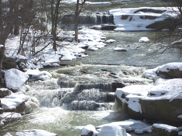
Escarpment). At Berea Falls, you can actually see the
northern face of the Berea Escarpment as the water cascades down
it, slowly eroding it and flattening it out.
What you see at Berea Falls, however, is only a small section of
this 200-mile long escarpment. It begins in Berea just east of here
and extends westwards into Erie County, where it turns south and
continues on past Columbus. On a
map it resembles a giant upside-down J.
Although most of its length is buried beneath younger rock
formations and glacial deposits, you can see evidence of it at some
places, like here and at the
Lakefront Property at Edison Woods
Earthcache in Erie County. (At Edison Woods you can see it in
its "true form" - as a steep slope. At Berea Falls it has been
flattened out by glaciers and river erosion.)
But enough of that already - now it's your turn!
To claim credit for this cache, you must
visit the Falls and answer the following questions:
- The Berea Escarpment branches off of another escarpment at its
eastern end. What is the name of that escarpment?
- During what geological time period was the Berea Sandstone
formed?
- What is the name of the rock formation directly below
the Berea Sandstone formation, and at what location can you see
it?
The answers to all questions can be found at a kiosk nearby.
Although you might be able to find different answers from other
sources, only the answers from the kiosk will be
accepted.
Do not post the answers in your log entry! Instead,
geo-mail them to me within 3 days of logging your visit. (If you
don't, earthcaching rules require me to delete your log!) While
you're here, take the time to enjoy the
all-purpose trail and notice the vast
difference between the valley north of the escarpment and the
valley south of the escarpment in terms of width, depth and rock
formations (but please stay within the designated trails and
recreation areas). If you feel like visiting the location mentioned
in Question 3, follow the Valley Parkway 1/4 mile north. Also feel
free to post pictures (just don't post any pictures that will give
away the answers).
This is the first of a series of 4 Earthcaches that explore
the Rocky River:
|
# |
Cache Name |
Location |
Featured Rock |
|
1 |
|
East Branch |
Berea Sandstone |
|
2 |
|
West Branch |
Berea Sandstone |
|
3 |
|
junction of East & West Branches |
Cleveland Shale |
|
4 |
|
near mouth |
Chagrin Shale |
Thanks to the Cleveland Metroparks for supporting
geocaching and permitting this cache.
FTF - InIt4theCache (during a major blizzard,
no less!)
REFERENCES:
- "Berea Escarpment" Cleveland Metroparks signage (N41°22.706
W081°51.950)
- Roadside Geology of Ohio (First printing) by Mark J.
Camp. (This is an excellent book and a must-have for Ohio
Earthcachers!)
- Physiographic Regions of Ohio by C. Scott
Brockman. (Thanks to the Ohio DNR for sharing this informative document
on their website and to boatchick for finding it.)