 Výše uvedená souradnice je výchozí bod, odkud se již musí pešky; zde je také možné zaparkovat auto (zdarma). Z tohoto místa se vypravte jižne po zelené turistické stezce na 1,9km (+zpet) dlouhou procházku úchvatnou prírodou do srdce Národní prírodní rezervace Certova stena – Luc.

1.otázka c.1; 2.otázka c.2; 3.Certova stena; 4.balvanové more na svahu Luce; 5.prehrada Lipno II. ve Vyšším Brode
NPR Certova stena – Luc vznikla v roce 1992 sloucením dvou rezervací; jihovýchodního úpatí hory Luc (vyhlášeno v roce 1934) a západního svahu Certovy steny (1956). V roce 2004 došlo k rozšírení rezervace na dnešních 132,6261ha.
Hlavním duvodem ochrany NPR Certova stena – Luc (zarazené do nejvyšší maloplošné kategorie ochrany) je komplex spolecenstev otevrených sutí, reliktních smrkových a brezových boru, fragmentu kvetnatých bucin, sutového lesa a acidofilních svahových jedlin v clenitém terénu hluboko zaríznutého údolí Vltavy s reprezentantivními ukázkami periglaciální a fluviální modelace terénu. Výskyt významné entomofauny a druhove pocetné avifauny.
Geologie:
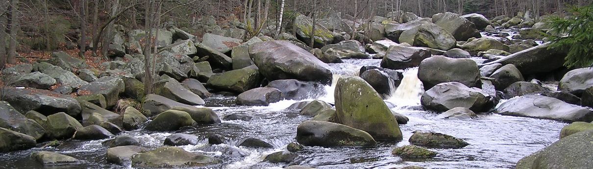
 Území rezervace (výškové rozpetí 600 - 933m n.m.) je soucástí moldanubického plutonu. Lokalita NPR se nachází v Lucské hornatine, která je nejvýchodnejší cástí Trojmezenské hornatiny (Šumava). Masiv Luce a protejší svah a vrcholová skaliska Certovy steny jsou tvoreny stredne zrnitou až drobnozrnou muskovit-biotitickou žulou eisgarnského typu. Hrbet vybíhající od Certovy steny k severu na pravém brehu Vltavy tvorí prevážne muskovit-biotitická pararula (moldanubikum). Na úpatí svahu jsou úzké pruhy deluviálne soliflunkcních, prevážne kamenitých a blokových sedimentu (období pleistocén - holocén). Celé území je velmi svažité a geomorfologicky clenité a jsou v nem ukázkove vyvinuty skalní útvary dokládající periglaciální modelaci terénu - mrazové sruby, izolované skály (tory), skalní hradby a rozsáhlá balvanová more.
Nejznámejší útvar (Certova stena) je mohutná žulová skalní hradba tvorená dvojslídnou žulou rozpukanou do kvádru bizardních útvaru. Pod skalní hradbou leží velké balvanové more tvorené nakupenými obrovskými lavicovitými balvany o nekolikatunové hmotnosti, které vznikaly mrazovým zvetráváním a samovolným rozpadem žuly, hlavne v dobách ledových, které se následne uvolnily a nekteré sesypaly do údolí. Velká balvanová more se nacházejí rovnež na jihovýchodních svazích hory Luce - spatríte z místa, kde budete plnit úkol c.2 (pozn. ownera: podle me je toto balvanové more ješte úchvatnejší než známá Certova stena). Do rezervace patrí i cást prirozeného koryta reky Vltavy s charakteristickou balvanitou sutí - recište je vyplneno žulovými balvany, na nekterých z nich jsou charakteristicky vyvinuté evorzní tvary, tzv. obrí hrnce.
Fauna a flóra:
Nejvýznamnejším typem vegetace jsou reliktní acidofilní smrkové a brezové bory, v jejichž rozvolneném stromovém patre prevažují borovice lesní, bríza karpatská s prímesí brízy belokoré, smrku ztepilého a vzácne i dubu zimního. V druhove velmi chudém bylinném podrostu dominují boruvka cerná, brusinka obecná a metlicka krivolaká. V zapojenejších porostech boru mimo kamenité sute je soustreden výskyt fytogeograficky významného druhu vresovce pletového.
V otevrených i zalesnených sutích se nacházejí velmi cenná spolecenstva bezobratlých, hlavne brouku a pavouku, žije zde napr. chránený zdobenec skvrnitý. Bohatá je rovnež avifauna - mezi nejpocetnejší patrí penkava obecná, cervenka obecná, sýkora uhelnícek a budnícek menší. Pro porosty reliktních boru na skalních sutích je charakteristická prítomnost rehka zahradního. Chránené území je tradicním hnízdištem výra velkého.
Od roku 1959, kdy byla zprovoznena Lipenská prehrada, je prepadová voda odvádena podzemním kanálem (dlouhý 3,5km v hloubce až 350m) pod horou Luc do nádrže ve Vyšším Brode a korytem Vltavy tak protéká pouze 1,5m3/s vody.
Pokud si chcete zalogovat tuto Earthcache, musíte splnit tri následující úkoly:
1. N 48° 38.170´ E 14° 16.560´ - napište mi na email jaký živocich je zde vyfocen
2. N 48° 37.681´ E 14° 16.555´ - napište mi na email jméno, které zde vidíte
3. K logu nahrajte alespon jednu fotografii kdekoliv na úseku této EarthCache tak, aby bylo zrejmé, že jste tuto EarthCache osobne navštívili! Samozrejme bez fotospoileru na 1. a 2.stage!
!PROSÍM, O DODRŽOVÁNÍ ZÁKAZU! (níže symbolicky uvedeny)
Predevším je na území NPR Certova stena - Luc zakázáno vstupovat kamkoliv mimo ohrazenou vyhlídku nad pravým brehem Vltavy a mimo turisticky znacenou cestu na levém brehu Vltavy. V prípade NPR Certova stena - Luc se nejedná jen o obecný zákaz vyplývající ze zákona, ale je to opravdu nutné z pohledu praktické ochrany prírody. Balvanitá sut, která je jedním z hlavních predmetu ochrany v NPR Certova stena - Luc, je velmi specifickým ekosystémem, který (ac se to laikovi mnohdy nezdá) reaguje velmi citlive na sešlap. Balvanitá sut hostí mnoho druhu ohrožených (a zákonem chránených) druhu mechorostu a lišejníku a je domovem citlivých spolecenstev hmyzu a pavouku.

V celé oblasti je relativne špatný signál GPS, proto omluvte prípadné odchylné zamerení, nicméne oba úkoly z terénu jsou zcela jednoznacné.
PS: Nezapomente si vyhledat fyzickou cache GCYP18, kolem které budete procházet.
0001. Eartcache v Jihoceském kraji
0048. Earthcache v Cesku
2500. Earthcache na svete
 The aforementioned coordinate is the point of departure. There you can park your car (for free). From this point, you have to go to the south, following the green touristic path. The little journey, about 1,9km long (+back), through a delightful landscape, leads to the Devil’s Cliff - Luc National Nature Reserve. Devil’s Cliff - Luc NNR was founded in 1992 by merging two previously existing reserves. Luc had been a protected territory since 1934 and the Certova stena cliff since 1956. In 2004 the NNR territory was extended to its current area of 132,6261ha. The NNR includes a complex of communities of open talus, relict pine forests with spruce and birch, fragments of herb-rich beechwoods, talus and ravine forests and acidophilous fir slope stands in the rugged terrain of the deeply incised Vltava river valley. Other reasons for protecting the area are the rich insect and bird life found here. The geological basement is generally formed by muscovite-biotite paragneiss of the Moldanubicum Zone. The whole territory is extremely rugged and we can find rock formations which demonstrate the effects of periglacial relief shaping frost-riven cliffs, tors, castle koppies and extensive boulder fields. The most well-known formation, Devil’s Cliff is a massive granite rock wall under which lies an extensive boulder field formed of piles of massive blocks up to 2 x 3m in size. A block field of large boulders is also located on the SE slopes of Mt. Luc. Part of the natural river channel of the riverbed is filled with granite boulders which display typical evorsion forms, the so-called potholes. A notable complex of relict forest and non-forest vegetation communities on rocky localities has been preserved on the NNR territory. The vegetation on the rock formations and exposed talus consists mainly of moss and lichen communities including the rare species of cup lichen Cladonia stellarisParmelia centrifuga, which has its only current locality in the Czech Republic on Mt. Luc. The most notable vegetation community are the relict acidophilous pine growths with birch and spruce, with predominant tree species Scots pine (Pinus sylvestris) and Carpathian birch (Betula carpatica) accompanied by the birch Betula pendula, Norway spruce (Picea abies), rowan (Sorbus aucuparia) and occasionally sessile oak (Quercus petraea). The herb layer is very poor in species but includes bilberry (Vaccinium myrtillus), cowberry (Vaccinium vitis-idaea) and wavy hair-grass (Avenella flexuosa). In more compact pine stands away from the rocky talus we can also find the species of phytogeographical significance – the heath Erica carnea. The narrow alluvial belt of the Vltava river is formed by linear growths of black alder (Alnus glutinosa) with smaller populations of grey alder (Alnus incana) and crack willow (Salix fragilis) on both banks of the river. Very valuable invertebrate communities inhabit the forested and forest-free talus slopes and especially beetles and spiders which include the protected bee beetle (Trichius fasciatus). The bird community here is also rich and includes the chaffinch (Fringilla coelebs), robin (Erithacus rubecula), coal tit (Parus ater) and chiff-chaff (Phylloscopus collybita). In the relict pinewoods on the boulder fields a typical species is the redstart (Phoenicurus phoenicurus). The NNR is a traditional nesting territory of the eagle owl (Bubo bubo). The NNR territory is very attractive for tourists and the rocky summit of the Devil’s Cliff is accessible from the car park by the Vyšší Brod – Loucovice road and a marked hiking and cycle trail run along the other side of the river. Information panels for visitors are places above and below the Devil’s Cliff. Since 1959, when the water dam Lipno was opened, the waste-water has been
 drained through a subterranean tunnel, under the Luc rock, to the basin in Vyšší Brod. Only 1,5m3/s of water runs through the watershed of Vltava river.
If you want to log in this Earthcache, you have to complete three of these following tasks:
1.
N 48° 38.170´ E 14° 16.560´ - write me an email with the name animal on the picture
2. N 48° 37.681´ E 14° 16.555´ - write me an email with the name you see there
3. Add at least one photo from your journey, where you pose with the GPS. Of course, without fotospoiler on 1. and 2.stage!
!PLEASE, RESPECT THE RULES! (symbolically mentioned below)
In the area of Devil’s Cliff- Luc, it is, above all, strictly forbidden to step out of the marked observatory on the right bank and outside the touristic path on the left side of the Vltava river. In the case of Devil’s Cliff- Luc, it is not only a general restriction implicit in the law, but it is really necessary from the environmental point of view and nature protection. The boulder detritus, which is the most important objective of the protection of the area, is a very specific ecosystem which (however imperceptible to a man) reacts sensitively to the footsteps. This boulder detritus contains many kinds of mosses and lichens in danger and therefore protected by law. It also holds number of communities of different insects and spiders.
In the whole area, there is rather a bad signal for GPS, therefore there might be some little devious directions, for which I apologize. However, both tasks are quite obvious and easy to complete. PS: Don’t forget to find the physical cache GCYP18, which you will pass by.
 Antworten an Fragen 1. und 2. mir schreib an email!
1. N 48° 38.170´ E 14° 16.560´ - Welches Tier siehst Du auf diesem Foto (lateinisch Benennen)?
2. N 48° 37.681´ E 14° 16.555´ - Welchen Namen siehst Du hier?
3. Füge ein Foto (Du oder GPS) deines Besuches bei der "Teufelswand" deinem Log bei. Fotografiert sich wo immer auf der Strecke! Natürlich ohne fotospoiler an 1. und 2.stage!