SLOVENSKO (Please find English description below!)
Geocache Ad Pirum – Pri Hruški
V casih, ko je bilo ozemlje današnje Slovenije del Rimskega imperija, je vodila državna cesta iz Aquileie (Oglej) preko Hrušice v Emono (današnja Ljubljana) in naprej v Panonsko nižino. Ta cesta je bila najpomembnejša povezava med Sredozemljem in notranjostjo kontinenta. Danes ta cesta povezuje Ajdovšcino z osrednjo Slovenijo.
Rimska cesta je bila zgrajena za casa cesarja Avgusta (27 pr.n.š. – 14 n.š.). Pri iskanju tega geocacha se boste ustavili pri dveh trdnjavah, ki sta bili zgrajeni ob tej cesti na in pri Hrušici. Da bi našli koncne koordinate, boste morali rešiti nekaj preprostih matematicnih nalog. Svetujeva vam, da greste na geocaching s kolesom, lahko pa se ga lotite tudi peš. Opozarjava pa, da je med prvo in drugo stopnjo kar 5 km ceste. Med drugo in koncno stopnjo pa se boste sprehodili v 5 minutah.
1. stopnja - N 45°53,297; E014°09,811:
Utrdba na Lanišah (Lanišce na nekaterih zemljevidih) je bila del obrambnega sistema Claustra Alpium Iuliarum, ki je bil sestavljen iz mnogih prež, obzidij in obrambnih stebrov, vecjih oporišc kakršna so bila Castra v Ajdovšcini, Ad Pirum na Hrušici, Nauportus na Vrhniki in manjših, kakršne so tudi Laniše. Obrambni sistem je varoval obmocja, kjer je bilo najlaže prehajati iz Panonske nižine in Balkanskega polotoka na današnja italijanska ozemlja.

Na gornjih koordinatah boste našli obnovljeno utrdbo, ki predstavlja edini primer rekonstruirane arhitekture tega pozno anticnega obrambnega sistema v Sloveniji. Tukaj boste morali storiti sledece:
1. preštejte število vrat na utrdbi = X
2. preštejte strelne line na utrdbi = Y
3. preštejte male stebricke na obzidju = Z
2. stopnja N 45°51,791; E014°06,732:
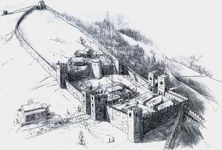
Od prvega stoletja našega štetja, je bila Ad Pirum poštna postojanka, kjer je bilo mogoce tudi zamenjati in nahraniti konje, od 2. stoletja dalje pa tudi stražna postojanka. V drugi polovici 3. stoletja je bila na Hrušici zgrajena vojaška utrdba (kastel).
Tloris kastela je prilagojen zemljišcu in je nepravilne ovalne oblike. Dolg je 250 m, širok do 75 m. Obdaja ga 2,7 m široko obzidje, ki je bilo visoko okrog 8 m. Utrjeno je bilo s stolpi. S precnim zidom, skozi katerega je bil narejen ozek prehod, je kastel razdeljen na spodnji in zgornji del. Slednji je lahko služil za takticni umik v stiski, za šotorišce ali živinsko stajo. V spodnjem delu utrdbe so bili poštna postaja, vojaške barake in cisterna. Cesta Aquileia - Emona je preckala spodnji del kastela v smeri zahod – vzhod. Vzhodni vhod v utrdbo sta šcitila dva približno 10 m visoka stolpa. V skalnih tleh so še ohranjeni sledovi tecajev vrat, s katerimi je bilo mogoce vhod zapreti.
Na koordinatah druge stopnje boste našli vklesan znak z eno crko in eno dvomestno številko. Rdeca barva znaka je nekoliko zbledela, a sta crka in številka še vedno jasno berljivi. Vaši nalogi na tem mestu sta:
4. vzemite crko iz znaka in jo obravnavajte kot številko v šestnajstiškem sistemu. Dobljeno številko pretvorite v decimalni sistem = Q.
5. vzemite številko iz znaka in upoštevajte zgolj drugo cifro = W.
Koncne koordinate boste dobili s pomocjo naslednjih formul:
N 45°51,aaa
E014°0b,ccc
Kjer velja:
aaa = QxZ – W + X
b = W
(X + Y)xZ = ŠTEVILKA. Preuredite cifre dobljene ŠTEVILKE od NAJVECJE do NAJMANJŠE in tako dobite ccc. (Na primer: ce bi bila ŠTEVILKA = 123, bi bil ccc = 321).
Prvotna vsebina geocacha:
- list z opisom (ne odstranjuj!),
- blokec za vpise, svincnik, kemicnik (ne odstranjuj!),
- silicagel (ne odstranjuj!)
- trak za kljuce,
- obesek za kljuce
- GC Kansas Sunshine
- Presenecenje za prvega najditelja!
Želiva vam veliko užitkov pri iskanju tega geocacha. Dodatne informacije o utrdbi na Hrušici pa lahko najdete na:
Stara pošta
ENGLISH
Geocache Ad Pirum – Pri Hruški
At the time, when the territory of present Slovenia was comprised in the Roman Empire, a state road led from Aquileia via the Hrušica plateau to Emona (present Ljubljana) and forward towards the Pannonia. It was the most important connection between the Mediterranean and the interior of the continent. Today, this road connects Ajdovšcina to central Slovenia.
The Roman Road was built under the ruling of Emperor Augustus (27 BC – 14 AD). This multistage geocache will lead you to two fortifications that were built along this road on and near the Hrušica plateau. You will have to perform some easy mathematical tasks to obtain the final coordinates. The geocaching is best done on a bicycle. You can do it on foot as well, but please note that there is a 5 km road from the first stage to the second, which will probably take you more than an hour. Good news is that there is only a 5 minute walk from the second stage to the final coordinates.
1. stage N 45°53,297; E014°09,811:
The fortification on Laniše (Lanišce on some maps) was a part of defence system called Claustra Alpium Iuliarum. It was built of many lookouts, block walls and forts, big stronghold such as Castra in Ajdovšcina, Ad Pirum on the Hrušica plateau, Nauportus in Vrhnika and smaller ones such as Laniše. The system protected the area where it was the easiest to pass from Pannonia and the Balkan Peninsula to the Italian territory. At the above coordinates you will find a unique example of reconstruction of the late antique defense architecture. Here, you will have three tasks:
1. Count the number of door of the fort = X
2. Count the number of loopholes = Y
3. Count the number of small pillars on top of the wall = Z
2. stage N 45°51,791; E014°06,732:
From the 1st century AD on, Ad Pirum was a postal station and a station to change and feed horses. However, from the 2nd century on it was also a guard military post. In the second half of the 3rd century a small military stronghold was built in Ad Pirum.
The ground plan of the stronghold was adapted to the surface and thus of a deformed oval shape. The stronghold is 250 m long and up to 75 m wide. It is surrounded by a 2.7 m wide wall, which used to be 8 m tall, and fortified with towers.
At the second stage coordinates you will find a sign with one letter and a two digit number chiseled in the remains of the wall. The red colour of the sign has slightly faded, but it is still clearly readable. Please perform the following tasks:
4. Take the letter from the sign and think of it as a hexadecimal number. Convert it to decimal number = Q.
5. Take the number from the sign and use only the second digit = W.
The final coordinates are obtained using the following formula:
N 45°51,aaa
E014°0b,ccc
Where:
aaa = QxZ – W + X
b = W
(X + Y)xZ = NUMBER. Arrange the digits of this NUMBER in DESCENDING order and you will get ccc. (For example, if NUMBER would be 123, ccc would be 321).
Initial contents:
- Stashnote (Please,, do not remove!)
- Logbook, pen, pencil (Please,, do not remove!)
- Silicagel (Please,, do not remove!)
- Key belt
- Key pendant
- GC Kansas Sunshine
- Surprise FTF Prize!
We wish you a lot of fun searching for the geocache. You can find some additional information about Ad Pirum here:
Old Post