Historie
Pocatky tezby
Prvni zprava o cinu na severni strane hory Smrku pochazi z roku 1576. V 80. letech 16. stoleti pak tehdejsi vrchnost z Frydlantu pozvala horniky z Krusnych hor a Tyrolska, ubytovala je v Ludvikove pod Smrkem. Hornici otevreli behem nekolika let nekolik stol a zacali tezit cin.
Vrchol tezby
V roce 1584 bylo zalozeno nove Mesto pod Smrkem jako hornicke mesto. V roce 1592 mu byla udelena privilegia jako hrdelni, hornicke a nekolik dalsich. Do roku 1622 bylo zapsano v novomestskem reviru cca 70 hornickych del. Vynosy z dolu vsak nebyly takove, jake se cekaly a proto hornictvi od 30. let 17. stoleti upada. V oblasti se tezi uz jen minimalne v nekolika dolech, aby mesto neprisla o sva prava. Tezba rudy se udrzovala az do roku 1845, kdy nadobro skoncila.
Nedavna historie a soucasnost
V roce 1953 byl proveden na Rapicke hore a Medenci geologicky pruzkum, ktery zjistil, ze je cin prilis rozptyleny, nez aby se vyplatilo ho tezit.
V soucasne dobe je vetsina stol zatopena, popripade zabezpecena mrizemi pro ochranu zdravi navstevniku a netopyru, kteri v nich prezimuji.
Popis cache
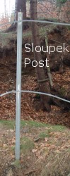
Cesta k cache je asi 2,5 km dlouha prochazka (asi hodina cesty pro zdatneho turistu, s detmi pocítejte minimálne 2 h) jak po cestach, tak mimo ne - jejich pomer zalezi jen na vas a vasem smyslu pro orientaci, ale volným lesem pujdete v každém prípade. Behem hledani napoved si budete moci prohlednout minimalne 5 ruznych pozustatku stol, z nichz jedna je omezene pristupna. V okoli stol je nebezpeci padu a zlomenin, proto doporucuji pevne boty, obleceni do lesa, opatrnost, v obdobi snehu dobrou fyzicku a v obdobi klistat neco proti nim. Stoly nejsou prilis turisticky navstevovane a casto k nim nevede zadna zretelna cesta. Samotna cache je mensi plastova krabicka se zamkem.
Pokud budete vymenovat predmety, vkladejte je prosim do zaviracich sacku, at dele vydrzi neosuntele.
Cesta k cache
Cast prvni - doprava k prvni stole
Pokud jedete autem, dojedte (po vychodni silnici, po zapadni je zakaz vjezdu) na parkoviste na souradnicich 50° 54,888' N, 15° 14,138' E.
Pokud jdete pesky, nebo nechate auto na namesti, drzte se modre turisticke znacky smer Smrk, ktera vede z vlakoveho nadrazi Noveho Mesta pod Smrkem pres namesti, kde zastavuje autobus. Dojdete take na vyse zminene parkoviste. Odtamtud uz nasledujte sipku sve GPS k prvni stole na souradnicich 50° 54,619' N, 15° 14,260' E. Prvni cast je relativne lehka, da se dojit az na par desitek metru od stoly po ceste. Jedna se o 15 m dlouhou stolu Nebeske vojsko, ve ktere se tezilo v letech 1582 - 1642 - byla jedna z prvnich. Vchod je zcasti zavalen a chranen mrizi. Nenechte se zmást info tabulí s jiným názvem, zdroje se liší.
Vedle vchodu do stoly je jama, ktera je ohranicena plotem. Spocitejte pocet sloupku plotu a dostanete cislo A.
Cast druha - slapeme do kopce.
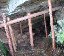
Nyni budete muset vyjit docela prudky kopecek ke druhe zstavce teto multiny na souradnicich 50° 54,626' N, 15° 14,745' E, - stole Erasmus. Toto je jedno z nejstarsich a nejvetsich dulnich del na severni strane Jizerskych hor, turisticky zajimave je proto, ze je mriz az ve vetsi hloubce stoly, lze se tedy dostat dovnitr (coz oceni nejen deti, nicmene urcite dbejte zvysene opatrnosti, z vnitrku stoly se nikam nedovolate). Tezilo se v nem v letech 1580 - 1642.
Ziskani pismena B bude trochu zajimavejsi. Primo nad vchodem do stoly na danych souradnicich roste z kraje skaly strom. Urcete co je to za strom a ziskejte ho:
- Smrk: B = 1
- Borovice: B = 3
- Briza: B = 5
- Dub: B = 7
Cast treti - pruchod lesem
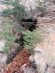
Nyni se dopravime ke treti stole na souradnicich 50° 54,461' N, 15° 14,890' E. Lezi sice zhruba ve stejne nadmorske vysce jako Erasmus, ale necekejte ze pujdete po rovince nebo prilis dlouho po ceste. Jmeno stoly je Nadilka stesti, je to velmi rozsahle dilo, kde se tezily v dobe 1631 - 1785 sulfidy a pyrhotin.
Na danych souradnicich je informační tabule. Spočítejte počet vchodů do štoly v okruhu 10 m (včetně zazděných), získáte číslo C.
Cast ctvrta - vychodni svah Medence
Prejdete vrchol Medence az na souradnice 50° 54,689' N, 15° 15,101' E, kde najdete stolu se jmenem Oukrop. Byla zrejme soucasti stareho doloveho pole, dalsi informace se nedochovaly.
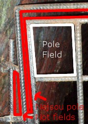
Na danych souradnicich je vchod do stoly opatreny mrizi. V teto mrizi jsou dvirka, ktera jsou zamrizovana svislymi a vodorovnymi ocelovymi pruty. Spocitejte pocet obdelnikovych poli, ktere tyto pruty tvori (proste pocet "okynek" mezi mrizemi ve dvirkach) a dostanete cislo D.
Cast pata - jeste nize po svahu
Dalsi cast je kratsi - sejdete jeste kus dolu po svahu na souradnice 50° 54,757' N, 15° 15,363' E, kde najdete dalsi stolu - Petr a Pavel. Puvodne povrchove tezeny dul, ktery vsak ma nekolik dedicnych stol. Tezilo se v nem v letech 1583 - 1609. Pozor, stol je v okoli nekolik (jedna asi 10 m od teto), sloupky je však ohranicena jen tato.
Ziskani cisla E neni prilis originalni - opet spocitejte pocet sloupku drzicich plot kolem stoly.
Cast sesta - hledame cache
Jeste si spocitejte nekolik pomocnych pismen, pro jistotu sem zopakuju i ty, ktere jste meli najit:
- A = pocet sloupku u Nebeskeho vojska
- B = strom nad vchodem do stoly Erasmus, smrk: 1, borovice: 3, briza: 5, dub: 7
- C = pocet vchodů do Nadilky stesti
- D = pocet poli ve dvirkach do stoly Oukrop
- E = pocet sloupku u stoly Petr a Pavel
- F = D - E
- G = E - B
- H = A - 4C - 1
Souradnice kde najdete cache jsou: 50° 54,FGH', 15° 15,GGE'.
Kontrola: Ciferace (F + G + H) je 3.
Nekolik poznamek
K jednomu dolu je casto vice stol. Na to myslete zejmena kdyz pujdete lesem (abyste nikam nespadli), dale kdyz u nejake stoly budete a mate cas, prozkoumejte okoli, muzou tam byt dalsi. A za treti, pokud najdete na internetu nejakou fotku, ze ktere je patrna nektera nepoveda k finalovym souradnicim, muze to byt fotka k jine stole k tomu samemu dolu, takze silne doporucuji si vsechny stoly opravdu projit.
Na mnoha mistech kde budete neni signal k mobilnim telefonum, nebo chytnete pouze signal z Polska či Německa. Nabijte si tedy telefon a pred volanim zkontrolujte z jake volate site.
V mistech kudy pujdete se casto dari houbam a boruvkam, v houbarske ci boruvkove sezone doporucuji se podle toho zaridit ;)
Celou dobu se budete pohybovat v chranene krajinne oblasti, pravidla chovani najdete na jejim webu.
Úzké štěrkové cesty vedoucí po vrstevnici patří k singltreku. Chodit po nich můžete, ale silně to nedoporučuji, cyklisté se po nich často pohybují rychleji, než byste čekali.
Z cache doporucuji pokracovat na mou druhou multicache - GC1ACXR - Stoly na Rapicke hore.
Nebojte se použít hint, v míste finálky je slabý signál.
History
Origins of mining
The first note about tin on the northern slope of Smrk (Spruce) mountain is from year 1576. In 80's of the 16th century authorities from Frydlant invited miners from Krusne hory and Tyrol, accomodated them in near Ludvikov pod Smrkem. Miners opened a few adits in a few years and started to mine the tin.
The culmination
In 1584 Nove Mesto pod Smrkem was founded as a mining town. In 1592 some privileges as hanging and mining were assigned to the town. Until 1622 there was about 70 mines signed up in the district of Nove Mesto pod Smrkem. However, yields from mining wasn't so high as expected and that's why from 30's of the 17th century mining is declining. Only a few mines were still running, to keep privileges for the town. The mining was staying up until 1845, when it finally finished.
Recent history and present
In 1953 there was a wireline logging on Rapicka hora and Medenec, but they discovered that the tin is too scattered and that mining wouldn't be profitable.
In present, most of adits are afloat and protected with grate, because of safety for the visitors and bats, which are wintering over there.
Description of the cache
The way to cache is about 2,5 km (about 1,5 mi) long hike (but take account at least 1 hour of hiking for a good tourist) on both paths and outside the paths. While looking for the numbers for coordinates of the final cache, you'll see a minimum of 5 different remains of adits, from which one is accessible. In the surrounding of the stalls be aware of falling and fractures, I recommend good boots, proper clothes for forest, good physical condition in winter and in the period of ticks something against them. The adits are not very frequented, so there is no visible path to them very often. The cache itself is a plastic box with lock.
If you'll change items, put it into plastic bags please, to keep it neat and clean.
Way to cache
Part one - transporting to the first adit
If you're going by car, go (by the eastern road, the western one is banned) to the parking on coordinates 50° 54.888' N, 15° 14.138' E.
If you're going on foot, or you're leaving your car at the square of Nove Mesto pod Smrkem, follow the blue tourist mark in the direction to "Smrk", which is going from the train station through the square of Nove Mesto pod Smrkem, where the bus stop is. You'll go to the parking mentioned above. From there, it's up ty ou and your GPS reciever. Go to the first adit at coordinates 50° 54.619' N, 15° 15°14.260' E. The first part is quite easy, you can come a few tens of meters from the adit on a path. It's a 15 m long adit called Nebeske vojsko (Heavenly army), which was active from 1582 to 1642 - it was one of the first adits here. The entrance is partly cluttered up and protected with a grate. Don't let the info board confuse you, the sources differ in the correct name.
Next to the entrance to the adit there is a pit, which is secured with a fence. Count the steel posts and you'll get the number A.
Part two - getting higher
Now you have to go a little up the hill to coordinates 50° 54.626' N, 15° 14.745' E, where the Erasmus adit is located. This is one of the oldest and largest mines on the northern side of Jizerske hory (Izera mountains). It's interesting for tourists, because it's accessible (only the first few meters, then there is a grate again, but I think you wouldn't go there even if it wasn't there ;)) But be very careful when being inside, keep in mind that you can't call the ambulance from underground. The mining proceeded from 1580 to 1642.
Getting the B number is a little bit more interesting. Just above the entrance to the adit, there is a tree growing up just from the edge of the rocks. Decide what tree it is and get it:
- Spruce: B = 1
- Pine tree: B = 3
- Birch: B = 5
- Oak tree: B = 7
Part three - hiking through the forest
Now you have to go to another adit - it's almost of the same elevation, but don't think you won't go up and down. Choose your own way. The target coordinates are 50° 54.461' N, 15° 14.890' E. The name of the adit is Nadilka stesti (Distribution of presents of luck, very hard to translate :)), it's very large mining work, where sulfids and pyrhotin were mined from 1631 to 1785.
At the given coordinates, there is an info board. Count the number of entrances to this adit in 10m radius (including walled up ones) to get number C.
Part four - eastern slope of Medenec
Cross the summit of Medenec to coordinates 50° 54.689' N, 15° 15.101' E. This is wuite a longer way mostly out the paths, so prepare for that. You will find adit called Oukrop (this word is a name for a type of a soup). It was a part of old mining area, another information are not preserved.
At the given coordinates there is an entrance to the adit, secured with grate again. In this grate, there is a door. The rails in a grate form rectangular fields - simply the free space between rails of the door = one field. Count the fields in the door and you'll get number D.
Part five - lower down the hill
The next part is shorter - go a little more down the hill to coordinates 50° 54.757' N, 15° 15.363' E, where you'll find the next adit - Petr a Pavel (Peter and Paul). It was originally a surface mining mine, but it has some adits too. It was mined from 1583 to 1609. Beware, there are more adits near this (one is about 10 meters far), but this is the only one with poles.
Getting the E number is not very original - it's again the number of poles holding the fence around the adit.
Part six - looking for the cache
You need to count up a few more numbers, I repeat those which you should already have for sure:
- A = Number of posts next to Nebeske vojsko
- B = Tree above the entrance to Erasmus adit, spruce: 1, pine tree: 3, birch: 5, oak: 7
- C = number of entrances to Nadilka stesti
- D = Number of squares in the door to the Oukrop adit
- E = Number of posts at the entrance to Petr a Pavel adit
- F = D - E
- G = E - B
- H = A - 4C - 1
The coordinates where you'll find the cache are: 50° 54.FGH', 15° 15.GGE'.
Verification: The digital root of (F + G + H) is 3.
A few remarks
There are often more adits to one mine. Keep this in mind when you are going through the forest (to not fall somewhere) and where you have more time, you can look around for more adits. There can be adits, which are still not discovered! And the third point is, that if you'll find some photo on the internet, from which some answer to question here can be got, it can be a photo for the same mine, but another adit, so I strongly recommend to really pass all the stages.
At some places you visit is no signal for cell phones, or only from Poland. So charge you cell phone before the trip and check from what network you're calling before doing so.
There are a lot of mushrooms and blueberries growing along the way.
All the way to cache is in the protected landscape area of Izera mountains, you must not camp, start campfires, pull flowers etc.
Narrow gravel paths leading along the terrain contours belong to singletrack. It's allowed to walk on them, but I strongly discourage you from doing so, the cyclists are often moving faster than you'd expect.
I recommend to continue to my second multicache after this - GC1ACXR - Adits on Rapicka Hora.
Don't be afraid of using the hint, signal near the final stage is weak.