Massive rhyolite domes make up much of the landscape and were formed when lava oozed slowly from the vents and solidified. The 1,111 metre high Tarawera volcano is made up of three domes, Wahanga, Ruawahia and Tarawera. To the right and out of sight, lies Lake Rotomahana, on whose shores the World Famous Pink and White Terraces cascaded.
Directly in front of you lies the Waitoharuru inlet of Lake Tarawera. Boat trips to the Terraces were launched from here after tourists were transported down from the nearby Te Wairoa Village, prior to the Tarawera Eruption shortly after midnight on June the 10th, 1886. After the eruption, rescuers waded through mud to launch rescue missions across the lake. The subsequent rising and falling of the lake levels are clearly illustrated at the nearby Frayed Kiwis cache.
The eruption ripped a 17km cleft across the Tarawera domes, through Lake Rotomahana and up the Waimangu Valley. The Pink and White Terraces were destroyed and the land for kilometres around was coated with mud and volcanic ash. The activity began in the Rotomahana basin when intruding magma - unerupted lava - triggered a cataclysmic hydrothermal eruption. This was the climatic event of the whole upheaval and "Rotomahana Mud" fell over a wide area of the surrounding Bay of Plenty area. The nearby village of Te Wairoa was buried under more than a metre of mud and volcanic ash and other local Maori villages, camp sites and cultivations simply disappeared. The known death toll exceeded 100 and information from the nearby Buried Village states that more than 150 lives were lost.
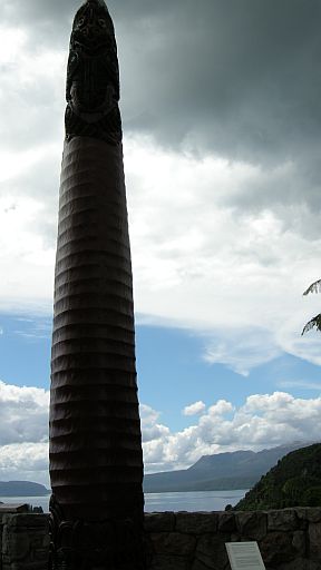 The loss to the Tuhourangi people, who owned the Terraces, was devastating. In former times, the Waka - canoe - of the chief would be placed on its end standing upright and partially buried into the ground during the Tangihanga - passing ceremony. To signify the homage and gratitude rendered to the great leader Tuhourangi, a symbolic Waka has been placed in this fashion at this historical site.
Iwi - extended family - from as far away as the Far North, Coromandel and the East Coast offered gifts of land for the surviving Tuhourangi people to re-establish their lives. It is the dream of Tuhourangi to one day return to their ancestral lands.
Tuhourangi have a spiritual interpretation of the events of 10 June 1886 and this is well documented in many media. I would recommend visiting the Rotorua museum in Government gardens and watching the short audio -visual presentation, hosted by Temura Morrison, for an excellent explanation of this. Time should be taken while you are at this earthcache to read the sign entitled "Tangata Whenua - The People of this Land", which is in both Maori and English. The legend as told here explains the events and provides an outlet for the grief felt.
I hope that the visit to this site has been useful and informative to you, blending as it does natural occurrences and legend. Yet this has happened in a time scale so recent that it is only one generation from people alive today and has forced significant environmental and social change upon the local landscape.
Questions to answer: The answers can be found or inferred from the signs at the viewing platform.
Directly across the road behind you, the road has been cut through the surface rock.
- What is the predominant colour of the rock?
- Explain the layering effect seen.
- A different colour may be seen near the surface. What colour is this and where did it come from?
- To the already carved Waka, what would be added to show tribal connections?
- What happened "as I look to Whakapoukorero"?
Please log this cache immediately you find it and also email me the answers to the above questions as verification. As well, a photo of part of yourself, GPSr visible and with the location clearly identifiable should be posted with your log to claim this as a 'find'. Logs containing 'answers' - including photos of the answers - will be deleted. Obviously, the cache must be found during the day. Thank you.
 Like this cache?
Come along and meet the CO and other Kiwi-Cachers online at:
Kiwicaching (Geocaching) New Zealand's Facebook Group
and: Kiwicaching's Facebook Page.