At 6,643 feet, Clingman's Dome is Great Smoky Mountains
National Park's highest point. It is the highest
point in Tennessee, and the second highest point east of the
Mississippi. Only North Carolina's Mt. Mitchell (6,684 feet)
rises higher.
Clingmans Dome is a popular Park destination. Located along the
state-line ridge, it is half in North Carolina and half in
Tennessee.
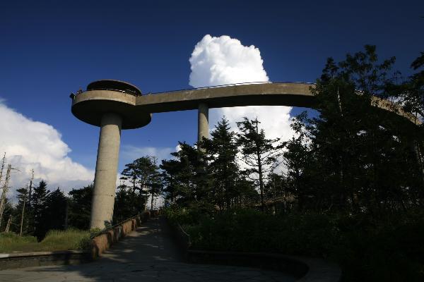
The peak is accessible after driving Clingmans Dome Road from
Newfound Gap, and then walking a steep half-mile trail. A paved
trail leads to a 54-foot observation tower.
The Appalachian Trail crosses Clingmans Dome, marking the
highest point along its 2,144 mile journey.
Vistas from Clingmans Dome are spectacular. On clear,
pollution-free days, views expand over 100 miles and into seven
states. However, air pollution limits average viewing distances
to 22 miles. Despite this handicap, breathtaking scenes delight
those ascending the tower. It is a great place for sunrises and
sunsets.
Cloudy days, precipitation, and cold temperatures reveal the
hostile environment atop Clingmans Dome. Proper preparation is
essential for a good visit. Weather conditions atop Clingmans Dome
change quickly. Snow can fall from anytime between September and
May. Get a current weather forecast before heading to the tower,
and ALWAYS take along warm clothing.
Remember: 'What it's like down there ain't what it's like up
here!'
The cool, wet conditions on Clingmans Dome's summit
make it a coniferous rainforest. Unfortunately, pests, disease,
and environmental degradation threaten the unique and fragile
spruce-fir forest. Dead trunks litter the area, and dying trees
struggle to survive another year. Berries thrive in the open areas,
and a young forest will replace the dying trees.
Although Clingmans Dome is open year-round, the road
leading to it is closed from December 1 through April 1, and
whenever weather conditions require.
People can hike and cross-country ski on the road during the
winter.
Clingman's Dome, like the other mountains of the region, was
created from fractured, faulted Precambrian rocks, overlayed with
the ancient Ocoee Supergroup of partially metamorphosed sedimentary
rock. The actual age of the mountains is somewhat speculatory, but
they are among the oldest in the world, likely somewhere from
200-300 million years old.
To claim this find, you must take your photo, GPSr in hand,
at the Clingman's Dome Observatory. Also, to demonstrate the
educational value of this Earthcache, you must email me the answers
to EACH of the following three questions:
1. How high is the High Point, Clingman's Dome?
2. Clingman's Dome, like the other mountains of the region, was
created from WHAT?
3. There is a uniquely shaped USGS benchmark at these
coordinates, describe the benchmark (any park ranger can help).
Answering EACH of these questions, plus your
photo, is a must. If your log is deleted, please re-read these
instructions and try again.
PLease email your answers to ARF! at this
address:
AirRaidFan@Yahoo.com
Please email your answers first, the LOG THE FIND.
Do not wait on a reply from me. FINDs which do not meet logging
requirements will be deleted.

 Bronze.
 Silver.
 Gold.
Gold. Platinum.
ARF! is an EarthCache
Master
You can be, too! Click on the Earthcache logo above
to see how!
Platinum.
ARF! is an EarthCache
Master
You can be, too! Click on the Earthcache logo above
to see how!
Earthcaching: Leave No Trace!