En
virkelig Geocache #1
For ca 420 millioner år siden strakk det en fjellformasjon seg fra
Skottland (Caledonia) over store deler av Norge, og opp til
Svalbard. Landområdene som i dag delvis utgjør Grønnland og Canada
hadde kollidert med kontinentet ”Baltica” og dannet en
fjellformasjon som overgår det Himalaya vi kjenner i dag.
Når platen som utgjør Grønnland og
Nord-Amerika trakk seg tilbake, etterlot den en fjellformasjon
bestående av fjell og berg som hadde blitt presset og brettet opp
dypt nedenfra et hav som lå der Atlanterhavet er i dag. Rester av
den gigantiske fjellkjeden finner vi i dag i Nord Irland,
Skottland, Norge, Svalbard, New Foundland, Appalachene og østkysten
av Nord-Amerika.
Fordi fjellet som ble brettet opp over
”Ur-Skandinavia” kom fra et lag i jordskorpen som har vært presset
sammen med et høyt trykk og under høy varme, har dette blant annet
fått betydning for fjellformasjonene og formasjonene i
bergartene.
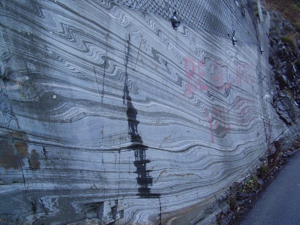
Det er en helt spesiell klar
avdekning av fjellet vi her ser, og som man ikke tenker over i det
den ellers passeres på vei til konsert eller en kopp kaffe ved
bryggen. I strukturene som ses ser vi helt klart både folder og
forkastninger som skyldes temperatur og høyt trykk.
Håper dette blir en steintøff opplevelse

Remains of a gigantic mountain ridge.
420
million years a mountain ridge stretched from Scotland (Caledonia)
over most of Norway, and up to Spitsbergen. Parts of Greenland and
Canada were formed when huge plates of the earth collided to form
mountains and highland.
When the
North American plate withdrew, it left behind a mountain formation
consisting of rock and stone pressed up from the depths of the
Atlantic Ocean. Parts from this gigantic mountain ridge can today
be found in North-Ireland, Scotland, Norway, Spitsbergen, New
Foundland, The Appalaches, and the east coast of
North-America.
High
pressure and high temperatures from deep in the earth caused the
plates to fold over the Pre-Scandinavia to form the mountains and
unique geological features.
It’s very
clear uncovering of the rocks you can see, and something you won’t
think of as you pass by on your way to a concert or for a cup of
coffee at the peer. In the structures can you see how the
temperature and the pressure have changed the layers in the
rock.
Good
luck! Rock on!
I want to
thank "Ghosthunter", my geocaching friend in Pennyslvania, for his
kindness and help with this cache as many others. He has not been
in Norway ever, but to work on caches together with him makes it
like a tiny little visit to Norway every time. And it is so
fun!!
For
å logge denne EarthCacheen må følgende
gjøres:
1. Ta et bilde av deg og GPSen din med en av veggene i bakgrunnen.
Legg dette bildet ved loggen.
2. Send meg en epost hvor du forklarer hvor høy de to veggene er
til sammen.
3. Skriv inn i loggen hvor mange du/dere var på turen og hva
du/dere har lært
To log this EarthCache as a find, you will have to do as
following:
1. Take a
picture of you and your GPS with one of the walls in the
background. Add the picture to the log.
2. Send me an email with the estimated hight of the two walls
added together
3. Write in the log how many people were on the visit, and
some of what you have learned.