The view at the peak of the Quarry, with the holes in the foreground
Logging the Cache
You can log this cache whether the summit is open or not s I have provided an alternative location should the summit be closed. If the walk to the top is not open, please do not attempt it. Alternate coordinates are listed below should the summit be closed. Answers can be gathered from either location.
[if summit is closed] - Optionally, but desirably, take a picture of yourself with together with your GPS by the closed path sign at:
S 27 07.445 W 109. 17.433
Please try and include some background to the picture too!
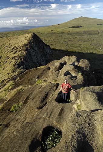
[only if summit is open]) - Optionally, but desirably, take a picture of yourself with together with your GPS by the holes and have Poike in the background (see picture provided with this cache for an example at:
S 27 07.496 W 109. 17.221
Please include some background to the picture too!
You will also need to answer the following questions (by email please, do not post answers on the
web page)
(i) to your NW is a pool of water. What is this formed in?
(ii) what do you call the plants growing in this pool of water?
(iii) to your NE is a mountain. How was this mountain formed (ask a park
ranger if unsure to any of these questions)?
WARNING!!!
A word of warning, please do not try and go up in strong winds as although
the path is safe (but steep) when the winds are light, it would not
be fun when the wind is blowing hard as you are very exposed up
there. The path is also quite steep in places and not for prams or
strollers. Once you are on the crater rim, the path is quite firm,
but the path up to the rim from the quarry can be quite slippery
when wet, especially in a downwards direction. I would advise using
the path up that is furthest from Ahu Tongariki if the path is wet
joins the crater rim at a lower point, and is also is less
slippery. If in any doubt as to the safety of climbing up on any
particular day, please consult a park ranger who will happily
advise you. If the summit has been closed, please do not attempt to climb.
I will accept a photo by the closure signs instead.
Please Note:- If the summit has been closed, please do not attempt to climb. I will accept a photo by the "No Pasar Peligro" or the "Keep Away Sign" instead.
The Holes at the Quarry
If you fancy something a little different on Easter Island, check
out the huge holes at the top of the cliff face at the Quarry (Rano
Raraku). From this location you get excellent views of Poike (the
oldest part of the island) and of Ahu Tongariki. I'd read about
these holes before visiting the island for the second time, and I
was interested to see them. I was expecting a few holes around
20-30 centimetres across, that would be easy to miss. In actual
fact the reality is much more surprising as with most things on
this island. The holes are very well carved and around a metre
across.
Again as with many other things on this island, the exact
purpose of them is far from understood. Some people speculate that
their purpose was for placing a tree trunk inside and then using
ropes to winch Moai (the carved heads) down the mountain. It all
sounds feasible until you consider that there don't seem to be any
Moai nearby to winch. Yet another theory is that tree trunks were
again put into the holes and then the warriors were lowered down
and dangled about (hanging down the side of a vertical cliff) as
some sort of training. A further theory is similar, only this time
spears were thrown at the warrior whilst he dangled to teach him to
dodge. I should imagine if he failed to dodge a spear, then a
Darwinian selection process would take place...
Anyway enough of the preamble, onto the cache.
The lesson
Easter Island is covered in volcanic craters. The island was formed over a
considerable number of years from 3 major volcanic eruptions. The
first eruption was at Poike, followed by Rano Kau (at Orongo - the
best formed volcanic cone). Finally these two distinct volcanoes
were joined together when Terevaka (the largest of Easter Islands
volcanoes) erupted and made the triangular shape that Easter Island
is today. Don't worry, none of these volcanoes is active today.
However what you can see from looking at Poike is how this is now
starting to decay and erode into the sea. This is worrying the
Islanders too. When I first visited the island, you could drive
into Poike with a 4WD. These days it is banned due to the extra
erosion it is causing. An excellent example of the erosion can be
seen maungas towards the North Coast of Poike. These would have all
been rounded mounds once upon a time, but you can see in my
attached photo that Maunga Parehe (the one closest to the sea) is
starting to slowly collapse into the sea and is no longer very
rounded at all. Unfortunately, this is shows what will happen to
all of Easter Island given enough time. It will slowly disintegrate
into the sea and nothing will be left. You can see that some of the
Moai are starting to disintegrate too if you look around the
island. Research is being done as to whether some sort of material
can be sprayed or coated onto the Moai to help slow this erosion
down, but I don't think it has got to far yet.
Finding the Cache
To find the cache, visit Rano Raraku and wander through the Moai.
Follow the paths upwards until you get up as far as the rim of the
crater. At this point (well there are more than one point), turn to
your right and head upwards along the crater rim (towards the
direction of Ahu Tongariki). Keep going until you can go no further
- as the crater wall drops significantly. The holes can be found at
the point just before where the drop happens. The view is also
quite spectacular towards Poike and Ahu Tongariki and also into the
crater lake.
If in any doubt as to the safety of climbing up on any particular day, please consult a park ranger who will happily advise you. If the summit has been closed, please do not attempt to climb. I will accept a photo by the closure signs instead.
Again, Please Note:- If the summit has been closed, please do not attempt to climb. I will accept a photo by the closure signs instead.
 Counter added 09th Jan 2010