Highest Point of Holmsland Klit
Dansk:
Holmsland Klit er en landtange der ligger mellem Ringkøbing Fjord og Nordsøen. En landtange er en smal aflang tange foran en bugt, der adskiller bugten fra det åbne vand, og består oftest af sand.
En tange opstår som følge af sandvandring, og bygges op fra kysten, hvor aflejringerne lægger sig i forlængelse af tangen. En fortsat sandvandring, medfører at tangen når land igen i den anden ende af bugten, og der opstår en lagune.
Holmsland Klit har en bredde på mellem få hundrede meter, og to kilometer, og består af sand og sandklitter. Der er få mindre byer på tangen, sommerhuse - og et fyrtårn.
Lyngvig fyr ligger på landtangen Holmsland Klit – midt mellem Nordsøen og Ringkøbing Fjord. Her er der dejlige klitter og sandstrande.
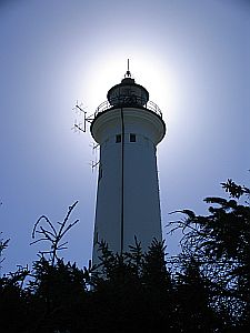
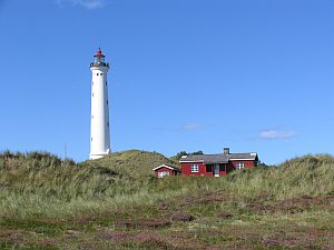 Klitterne omkring fyret er fredede, og der er fine vandreture i området. Ved fyrtårnet, som er Danmarks højeste, findes der et museum. Husk at gå en tur op i fyrtårnet og nyd den storslåede udsigt.
For at logge denne cache, skal du stille dig på det opgivne koordinat, og tage et billede af fyrtårnet og dig (optional), og svare på følgende spørgsmål: (send en e-mail med svaret)
1.) Hvor lang er tangen Holmsland Klit?
2.) Hvor høj er fyrtårnet?
Gem billedet, og upload det sammen med din log (optional).
Nyd din tur til Holmsland Klit
... and thanks to "toan" for his translation  !!!
!!!
German:
Holmsland Klit - also die Holmsland Düne - ist die Nehrung, die den Ringkøbingfjord im dänischen Jütland von der Nordsee abtrennt. Eine Nehrung (italienisch Lido) ist ein schmaler, meistens sandiger Landstreifen, der einen flachen Teil des Meeres vom offenen Wasser abtrennt.
Eine Nehrung entsteht durch Sandverdriftung bei der Bildung einer Ausgleichsküste. In früheren Zeiten nutzte man dies zur Eindeichung. Der vom Meer abgetrennte Teil wird Lagune, Haff oder Bodden genannt und enthält durch Süßwasserzufluss meistens Brackwasser. Nehrungen können, wie im Fall von Holmsland Klit auch Dünen tragen.
Weitere große Nehrungen sind in der Ostsee die Frische Nehrung und die Halbinsel Hel (früher Putziger Nehrung genannt) in Polen und die Kurische Nehrung zwischen Klaipeda und Kaliningrad sowie der Priwall vor Travemünde. Nehrungshaken findet man in der Hohwachter Bucht, an der Kieler Außenförde bei Wentorf und auf Fehmarn (Grüner Brink, Krummsteert).
Entlang der Nehrung Holmsland Klit, die im wesentlichen aus Sand und Dünen besteht und zwischen 2 Kilometer und wenigen hundert Meter breit ist, gibt es nur wenige kleinere Orte (Lyngvig und Havrvig), einen Leuchtturm (Lyngvig fyr), und in jüngster Zeit viele Ferienhäuser.
Vor dem Aufblühen des Tourismus trieben die Bewohner des nördlich gelegenen Holmsland im Frühjahr ihr Vieh über die Nehrung, wo es den Sommer verbrachte. Mit wachsender Bevölkerung wurde auch das Dünenland von fischenden Kleinbauern besiedelt. Im Dünensand gediehen Kartoffeln und Hafer, und der Lebensunterhalt wurde durch Fischen ergänzt. Für die wachsende Bevölkerung wurden im 19. Jahrhundert zwei kleine Kirchen gebaut (Lyngvig und Havrvig). Rundum gibt es wunderbare Dünenlandschaften und Strände, und im Osten liegt der Ringkøbing Fjord. Das Dünengebiet rund um den Leuchtturm steht unter Naturschutz, man kann wunderbare Dünenspaziergänge unternehmen. Im Leuchtturm (dem höchstgelegenen Leuchtturm Dänemarks) selbst befindet sich ein kleines Museum - aber man sollte es nicht verpassen, auf den Leuchtturm selbst zu steigen und das Panorama von oben zu genießen.
Um diesen Cache zu loggen begebt Euch zu den angegebenen Koordinaten, macht dort ein Foto von Euch (optional) und dem Leuchtturm und beantwortet die folgenden Fragen (Antwort bitte per Mail an mich!):
1.) Wie lang ist die Landzunge Holmsland Klit?
2.) Wie hoch ist der Leuchtturm?
Bitte hängt dieses Bild an Euren Logeintrag (optional).
Viel Spaß und eine gute Zeit auf Holmsland Klit!
English:
Holmsland Klit - the dune of Holmland - is a spit that separates the Ringkøbingfjord on the danish Jutland from the North Sea. A spit is a deposition landform found off coasts. A spit is a type of bar or beach that develops where a re-entrant occurs, such as at a cove, headlands and known as longshore drift. Where the direction of the shore ns inland (reenters) the longshore current spreads out or dissipates. No longer able to carry the full load, much of the sediment is dropped. This causes a bar to build out from the shore, eventually becoming a spit.
If the supply of sediment is interrupted the sand at the neck (landward side) of the spit may be moved towards the head, eventually creating an island. If the supply isn't interrupted, and the spit isn't breached by the sea (or, if across an estuary, the river) the spit may become a bar, with both ends joined to land, and a lagoon behind the bar. If an island lies offshore near where the coast changes direction, and the spit continues to grow until it connects the island to the mainland when it is then called a tombolo or a bar.
The spit "Holmsland Klit" is about 2 Kilometers to a few hundred meters wide and consists of dunes and sand. There are a few small cities (Lyngvig and Havrvig), a lighthouse (Lyngvig fyr) and some summer residences.
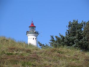 The Lighthouse from Nr. Lyngvig is positioned on Holmsland Klit between the Ringkøbing Fjord and the Northseacoast in the western part of Jutland. On this headland Holmsland Klit you can find wonderful dunes and beaches in the west and the Ringkøbing Fjord in the east. The dunes around the lighthouse are under nature protection, and you can do wonderful hiking tours in this area. In the lighthouse (the highest lighthouse of Denmark) you find a museum – but do not miss it to go on the lighthouse to enjoy the breathtaking view.
To log the cache please go to the mentioned coordinates, take a photo of you (optional) and the lighthouse and answer the following questions (please write me a mail!):
1.) How long is the spit of Holmsland Klit?
2.) How high is the Lighthouse?
Save your photo and put it to your log (optional).
Have a good time on Holmsland Klit!