Coordinates take you to general vicinity of the vistor center
parking lot of White sands National Monument. Park has a entarnce
fee and this is the only way to get a picture of the park without
paying a entrance fee.
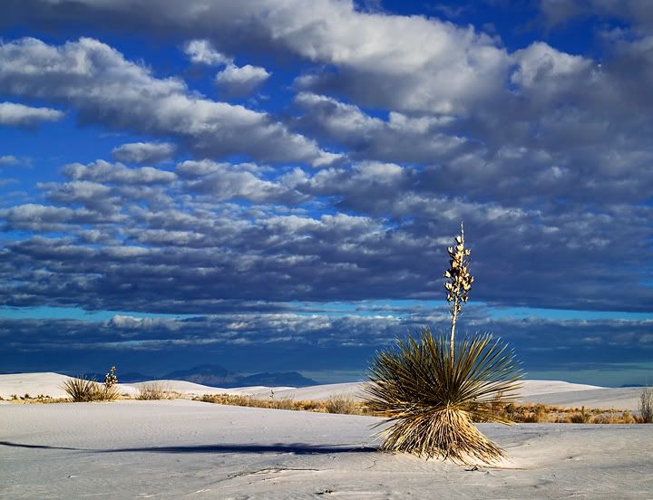
Rising from the heart of the Tularosa Basin is one of the
world's great natural wonders - the glistening white sands of New
Mexico. Here, great wave-like dunes of gypsum sand have engulfed
275 square miles of desert and created the world's largest gypsum
dune field.
White Sands National Monument preserves a major portion of this
unique dune field, along with the plants and animals that have
successfully adapted to this constantly changing environment.
The Tularosa Basin, a high desert area, averaging 4,000 feet
(1200 meters) in elevation, is subject to harsh, and sometimes
rapidly changing climatic conditions. Spring is windy season.
Summers are hot, averaging 95°F. (35°C.) highs with occasional
readings over 100°F. (38°C.). Winters are relatively mild, but
night-time temperatures often go below freezing (0°C.) Snowfall is
infrequent, but heavy snows have occurred on occasion.
Precipitation averages about 10 inches (250 mm.) per year, with
most falling during summer thunderstorms, often accompanied by
lightning and hail.

The gypsum that forms the white sands was deposited at the
bottom of a shallow sea that covered this area 250 million years
ago. Eventually turned into stone, these gypsum-bearing marine
deposits were uplifted into a giant dome 70 million years ago when
the Rocky Mountains were formed. Beginning 10 million years ago,
the center of this dome began to collapse and create the Tularosa
Basin. The remaining sides of the original dome formation now form
the San Andres and Sacramento mountain ranges that ring the
basin.
Gypsum comes from the Greek language, meaning 'to cook the
earth'. The mineral gypsum is chemically known as calcium sulfate
(CaSO4·H2O) with water. Calcium sulfate that is not bonded with
water is called anhydrite. Gypsum is typically very soft, a '2' on
the hardness scale (1=talc, 10=diamond). Our fingernails are of
hardness 2 1/2, so our nails can scratch the soft gypsum.
Gypsum is soluble, relative to most other rocks. It dissolves in
water into calcium ions and sulfate ions. It is an evaporite
mineral: the calcium and sulfate ions, when sufficiently
concentrated due to the evaporation of water, recombine and
precipitate out into gypsum or anhydrite. If you heat gypsum and
drive out most of the water you get another substance: Plaster of
Paris. Used for casts, and lots of construction uses, gypsum is one
of the oldest building materials in the world. Used for mortar in
Egyptian pyramids. Romans discovered its fire-resistant qualities:
doesn't burn and water in gypsum helps suppress fire. Gypsum has
many modern uses: medical treatments for setting broken bones,
wallboard, cement setting retardant, paint, soil conditioner,
crayons, even put in beer to help enzyme action and yeast
fermentation. Fortunately, gypsum is a very common mineral and is
mined from New York to California. There is no commercial threat to
the park.
Gypsum comes in many forms, found mostly in rock form. Very
fine-grained rock gypsum is called alabaster and is used for
sculpting. The crystal form is called selenite.

Its easy to get lost in the dunes. Do not wander far off of the
trails because you may get lost.
DO NOT LOG AS A FIND UNTIL YOU HAVE A PICTURE READY TO POST. To
get credit for this EC, post a photo of you (I do not accept
pictures of just a hand, a SHADOW of the finder, or pictures of
OTHER people) at the posted coordinates with any part of the WSNM
in the background and please. answer the following questions. .
1. What is the white sand? (Is it really sand or not)
2. Name one type of lizard that are native to the White Sands
National Monument?
3. How many square miles does the White Sand National Monument
cover?

| Cav Scout has earned GSA's highest
level |
 |
Logs with no photo of the actual EarthCacher/Geocacher (face
must be included) logging the find or failure to answer questions
will result in a log deletion. Exceptions will be considered if you
contact me first (I realize sometimes we forget our cameras or the
batteries die). Logs with no photos or incorrect photos will be
deleted without notice. I have used sources available to me by
using google search to get information for this earth cache. I am
by no means a geologist. I use books, internet, and asking
questions about geology just like 99.9 percent of the geocachers
who create these great Earth Caches. I enjoy Earth Caches and want
people to get out and see what I see everytime I go and explore
this great place we live in.
I ONLY ACCEPT PICTURES THAT CLEARLY SHOWS THE FINDERS INDENTITY.
A SHADOW, HAND, OTHER PEOPLE, PETS, ALIENS, BIGFOOT, OR A PICTURE
OF NO ONE IN IT WILL WILL NOT COUNT AS A FIND. THE FINDER CAN USE
THOSE PICTURES IF THEY USE A CORRECT PICTURE. A CORRECT PICTURE
SHOWS YOUR FACE AND HAS ANYPART OF THE WSNM IN THE BACKGROUND.