Szczeliniec Wielki -
The Stolowe Mountains
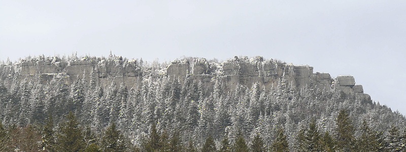
Szczeliniec Wielki - the highest peak of the Table Mountains is an exceptional tourist attraction in Poland. It is the remain of the highest level of the Table Mountains, where erosion sculptured magnificent rock forms. The most famous are: "Hen", "Mammoth" (also called "Ape Man"),"Camel", "Princess Emilka's Head", "Elephant", "Pulpit". A very interesting part of Szczeliniec Wielki is the so called "Little Hell". It is a crevice 100 meters long and about 20 meters deep with specific microclimate characteristic of low temperature and high air humidity. Because of the climatic conditions there is snow on the bottom of the crevice until mid June. There are 680 stairs made of stone leading to the top of Szczeliniec. They were built between the 18th and 19th century by Franciszek Pabel and after some alterations they have served until today. Szczeliniec Maly on the south-east of Szczeliniec Wielki, separated by a not very deep mountain pass is not allowed to visitors.
The Stolowe Mountains are the only example in Poland of mountains built of horizontaly laid rocky layers. These rocks, called joint sandstones, interlaid with marls were created in the sediments of the sea, which in late Cretaceous period (100 millions years ago) came to this region. They lie on an even older, dated from Permian period, sandstones and conglomerates. The development of the sculpture of the Stolowe Mountains began after the with drawal of the Cretaceous sea (about 70 millions years ago).
In the process of shaping the Stolowe Mountins the very important part was played by water, not only by erosion of the surface, but also its influence underground in the wellhead zone. In the first case, the chemical and mechanical erosion created fantastic rocky forms in the exposed parts of the joint sandstones on the top of Szczeliniec Wielki and Maly, Skalniak and Naroznik and also Radkowskie Skaly and Skalne Grzyby. In the second, the removal of the eroded rock by underground water on the contact of the permeable sandstones with the impermeable marls causes the creation of empty spaces inside the mountain. This is followed by the sandstones shattering and sinking. The changing climatic conditions through the period of 7 millions years had their impact on the intensity of the sculpturing process. The geometry of the forms was shaped by the rock fissuring and their shape resembling buildings, mushrooms, animals and people was determined by different rocky layers and different binding material of the rocks.
To the area of National Park except the Stolowe Mountains covering much bigger northern and eastern part belong also situated in the south-western region a part of Lewin Hills built form Kudowski granodiorite. This granodiorite comes form the Carboniferous period of Palaeozoic era (360 - 290 million years ago). Czartowski Kamien (Devil's Stone) and Czerwona Skalka (Red Rock) situated at Szosa Stu Zakretow (Way of Hundred Turns) belong to some of the exposures of these granodiorites. The sandstones in the neighbourhood of Pstrazna i Jakubowice are of the same age and you can find there traces of fossilized Carboniferous plants. The oldest rocks appearing in the area of the Park are mica slates surrounding Kudowski granite. As there is an easy access to the rocks building the Stolowe Mountains and Lewin Hills, they have been for a long time exploited in numerous although small stone-pits. Nowadays, only joint sandstones are mined in the stone-pits in Radkow and near Polanica Zdroj and they are used for building and stonework. In the 19th century in the neighbourhood of Pstrazna except rocky raw materials also hard coal was mined in the hardly efficient mines.
[CZ] 
Pro zalogovani cache musite splnit tyto podminky:
1) Pripojte k logu fotografii Vas s GPS z nasledujicich mist ( není podmínkou, ale za foto budu rád :) ):
a) Stage A: 50° 28.859 16° 20.392 (spolier)
b) Stage B: 50° 28.809 16° 20.380 (spoiler)
2) Poslete mi na email cztweety@gmail.com nasledujici udaje:
a) Rok vyhlaseni narodniho parku.
b) Nadmorskou vysku - Szczeliniec Wielki - Stage A
c) Z jake horniny je tvoren Szczeliniec Wielki
V souladu s pravidly budou smazany logy, nesplnujici uvedene podminky.
**********************************************************
[ENG] 
You must fulfill the requirements for log this cache:
1) Insert your photo with GPS picture to log from next places: (is not required, but I like )
a) Stage A: 50° 28.859 16° 20.392 (spolier)
b) Stage B: 50° 28.809 16° 20.380 (spoiler)
2) Send to my email cztweety@gmail.com following data:
a) The year of proclamation National Park.
b) Write your elevation above sea-level Szczeliniec Wielki - Stage A
c) By which kind of mineral is created - Szczeliniec Wielki
The logs which will not comply with the requirements will be deleted.