Read the requirements before starting your hike.. Then email me your answers to the tasks found below in the logging requirements.
You can best view the geology of this feature when the leaves are off the trees!
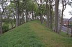 Atop a typical esker
An Esker is a long, winding ridge of stratified sand and gravel, examples of which occur in glaciated and formerly glaciated regions of Europe and North America. Eskers are frequently several miles in length and, because of their peculiar uniform shape, somewhat resemble railroad embankments.
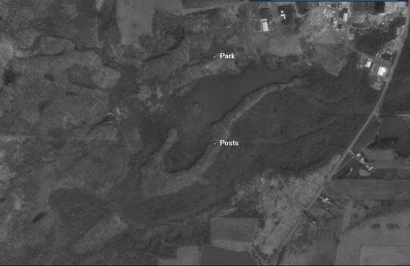
On an aerial photo, this esker resembles a fish hook
Most eskers are believed to form in ice-walled tunnels by streams which flowed within and under glaciers. After the retaining ice walls melt away, stream deposits remain as long winding ridges.
The esker forms when a vigorous sub glacial stream eroded a channel bed initially wide enough to contain those flanking depressions. The ice that surrounded the stream was under pressure from the glacier's weight. When the stream's flow diminished, the ice squeezed inward to form a narrower tunnel. The smaller, slower stream in the smaller ice tunnel could not carry as much sediment, and it began to deposit it on the streambed. As the sediments accumulated, they raised the level of the streambed and along with it the stream, which continually melted the ice above it and kept an open passage.
This narrow, raised streambed grew to a height that became the ridge one sees today above the surrounding plain.
The esker slopes down from the ridge along its length because the sediment slumped after the glacier melted away.
Eskers form near the terminal zone of glaciers, where the ice is not moving as fast and is relatively thin. The rate of plastic flow and melting of the basal ice determines the size and shape of the subglacial tunnel. This in turn determines the shape, composition and structure of an esker.
Eskers may exist as a single channel, or may be part of a branching system with tributary eskers. They are not often found as continuous ridges, but have gaps that separate the winding segments. The ridge crests of eskers are not usually level for very long, and are generally knobby. Eskers may be broad-crested or sharp-crested with steep sides. They can reach hundreds of kilometers in length.
The concentration of rock debris in the ice and the rate at which sediment is delivered to the tunnel by melting and from upstream transport determines the amount of sediment in an esker. The sediment generally consists of coarse-grained, water-laid sand and gravel. This sediment is stratified and sorted, and usually consists of pebble/cobble-sized material with occasional boulders. Bedding may be irregular but is almost always present, and cross-bedding is common.
Eskers are sometimes used for construction of highways as an economic measure. Be sure to note the way the village is utilizing this esker!
Logging requirements:
1. Use your GPS to determine the elevation at the parking area.
2. Walk to 41°16.459 81°14.014 and take another elevation reading.
3. Finally message me with the 2 elevation readings (indicate where you parked)and your estimate of how the the average width of the top of the esker (where it is level enough to walk) compares to it's average width at the base.
The 3 posts found at this location mark the end of the village property. The rest of the esker is on land owned by ODNR. The village of Mantua has received a grant for future development of the trail all the way to the end of the esker and back to the parking lot.
Feel free to post any photos, especially those showing the drastically different landscapes on the north and south sides of the esker.
Permission granted by the Village Administator of Mantua.
Sources: Wikipedia and
http://www.littlefallsmn.com/RipleyEsker.php