From the guidelines, as from January 2013"People do not need to wait for permission to log your EarthCache. Requiring someone to wait is not supported by the EarthCache guidelines. People should send their logging task answers to you, then log your EarthCache. When you review their logging task answers, if there is a problem, you should contact them to resolve it. If there is no problem, then their log simply stands."
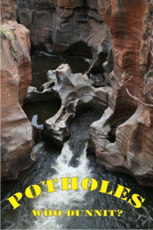

Cylindrical pothole growth on streambeds is a common enough occurrence throughout the world. We may often see them but apart from the aesthetic beauty resulting from the interesting shapes, we do little else to try to understand their significance. They are common in quartzite, dolomite, and granite.
Who dunnit?
Conventional explanation of potholes found in many geology text books state that potholes were caused by vortices in former streams that rotated and vibrated "grinding stones" over long ages of time, the process gradually wearing down a deep, cylindrical hole into the rock. The actual work of abrasion is considered to have been done either by hard grains of sand held in suspension by the rapidly flowing water; or by large boulders, called "grinders," in the bottom of the pothole, that were agitated constantly by the currents swirling around inside on the river bed. The tiny grains in the rapid currents are thought to have gradually worn down the rock into a depression that was deepened by the motion of the grinders.
The vortices may also be caused by the joining of two streams. At the confluence point, swirling masses of water rotate stones carried as river load that may grind into the substrate and wear out cylindrical features.
Potholes vary in size and can often be upwards of 12 to 15 metres wide and can reach remarkable depths at times in excess of 18 metres. Considering the remarkable depths of potholes, this process would seem to require great ages of time.
A word of warning!
Potholes are not limited to stream beds. Many are on top of cliffs high above the river bed.
Potholes that occur far from streams and valleys, sometimes high up on hillsides and mountains, are explained by geologists as the effects of the great ice ages of the Quaternary. Supposedly, during this time, there were potholes formed when the ice melted, as rivers flowed underneath the ice and on its surface. Sometimes these surface rivers plunged down a crevasse, and eroded the bedrock beneath, forming potholes on the most unlikely places, the glacial theorists claim.
The enigmatic questions
Pothole formation is not as straightforward as let on by the brief description you have read. Many questions remain to be answered using sound scientific principles. Some of the questions are:
1 - How is the process of their erosion in streams initiated?
Where the rocks of a stream bed are non uniform in texture, or are frequently intersected by joints, or have any kind of localized weakness, a small pit may be dug by differential erosion, or a hollow may result from the breaking out of a large fragment. Once a depression is formed in the bed of a stream it can become the lodging place of sand grains or pebbles slightly too coarse for the current to move across the low spot. The sand and pebbles do not, however, remain at rest. They are, more or less continuously, given a circular motion around the bottom of the hollow. By such grinding the depression is enlarged and deepened. In consequence more pebbles and more of the current are involved. Thus a pothole, progressively deepened and widened at the bottom, comes into being.
 2 - What causes the formation of a cylindrical depression in level bedrock?
When potholes occur in areas where bedrock is flat, it is unlikely that there would be much of a current that could initiate the pothole boring process. An initial depression of a few inches in the bedrock hardly seems likely to set up eddies in the stream flowing over it that could wear the depression into a hole several feet deep. Where the bedrock is inclined, the problem of the means of initiation of a vertical pothole is compounded. Why would the current bore a hole into the rock, rather than just flow across it?
Why don’t you try to answer some of these questions by observing some actual potholes and seeing if any of the above theories make sense or not?
The cache
The cache point is located on the Tuela River in northern Portugal. You will be standing on a bridge over the river where you can watch, looking straight down, at a number of potholes. In these you can still observe the “grinders” and for you to claim a find, please e-mail me the number of potholes you can see on the riverbed below and estimate the width of the largest pothole as well as its depth.

Marmitas de Gigante
Quem foi o culpado? 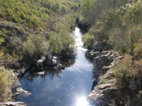
 A earthcache
Dirijam-se às coordenadas citadas e estacionem perto do santuário. Depois dirijam-se à ponte sobre o rio Tuela (conhecida na zona como a Ponte de Fresulfe) e olhem para baixo. Enviem-me as vossas respostas por mail que depois valido, ou não, o vosso found quanto ao número de marmitas de gigante que podem observar por baixo dos vossos pés e estimem a largura e profundidade da maior marmita.
Happy earthcaching!
 The most exciting way to learn about the Earth and its processes is to get into the outdoors and experience it first-hand. Visiting an Earthcache is a great outdoor activity the whole family can enjoy. An Earthcache is a special place that people can visit to learn about a unique geoscience feature or aspect of our Earth. Earthcaches include a set of educational notes and the details about where to find the location (latitude and longitude). Visitors to Earthcaches can see how our planet has been shaped by geological processes, how we manage the resources and how scientists gather evidence to learn about the Earth. To find out more click HERE.

______________________________________________________________________________