This is a Prime Location for a Seiche EarthCache
This is a Prime Location for a Seiche
-
Difficulty:
-

-
Terrain:
-

Size:  (not chosen)
Please note Use of geocaching.com services is subject to the terms and conditions
in our disclaimer.
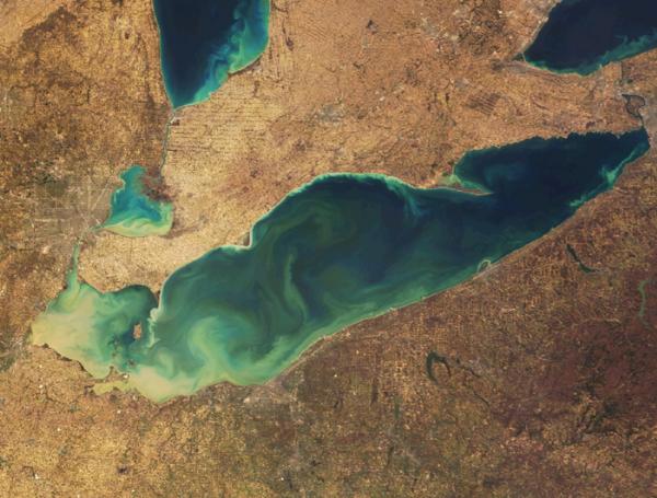
Question, why is Lake Erie choppy? It’s a
seiche!
Seiches- a standing wave in an enclosed or partially enclosed body
of water.
Lake Erie is the shallowest of the Great Lakes with an average
depth of 62 feet and with a maximum depth of 210 feet. The western
portion near Toledo, Ohio to the Lake Erie Islands all the way to
Cleveland, comprising one-fourth of the lake’s area, is shallower
with an average depth of 42 feet and a maximum depth of 62 feet.
For comparison, Lake Superior has an average depth of 483 feet.
Lake Erie is particularly prone to wind-caused seiches because of
its shallowness and elongation. Lake Erie's short-term level
changes are often subject to weather, since its shallowness and the
southwest-to-northeast alignment of its longitudinal axis make it
particularly prone to seiches, especially during high southwesterly
winds, when the lake water tends to pile up at one end of the lake.
This can lead to large storm surges, potentially causing damage
onshore. During one storm in November 2003, the water level at
Buffalo rose by 7 feet with waves of 10-15 feet on top of that, for
a cumulative rise of as much as 22 feet. Meanwhile, Toledo at the
western end of the lake will measure similar drops in water level.
After the storm event, the water will slowly slosh back and forth,
similar to the effect in a bath tub, until equilibrium is
re-established. The effect is similar to a storm surge like that
caused by hurricanes along ocean coasts, but the seiche effect can
cause oscillation back and forth across the lake for an extended
periods of time.
To claim a find, please email me the answers
to the three questions below. Also you will need to upload a
picture of yourself holding your GPSr with the nearby prominent
white and red structure in the background.
Question 1: How long is Lake Erie’s
southwest-to-northeast alignment of its longitudinal axis?
Question 2: What number in size is Lake Erie in relation of other
fresh water lakes in the world?
Question 3: What is the elevation of the current pool level of Lake
Erie? Walk to the shore and use your GPSr to take an elevation
reading.

Developed by A Platinum EarthCache Master
Additional Hints
(Decrypt)
Ybbx ng gur uvfgbevpny znexre naq qb abg sbetrg lbhe TCFe!