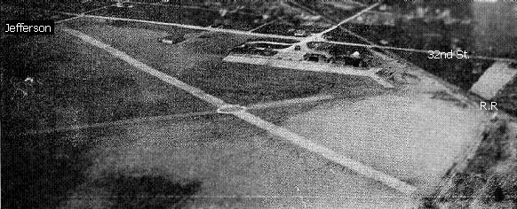
This cache is located on the site of the former Grand Rapids Airport. The airport was originally bounded by 32nd Street SE to the north, 36th Street SE to the south, the N.G. Railroad line to the east, and Jefferson Avenue to the west.
Groundbreaking for Kent County's first airport took place in 1919, on a site 4 miles from downtown Grand Rapids. The airport was the site of the United States' first regularly scheduled airline service in 1926, between Grand Rapids & Detroit, and in 1927, Charles Lindbergh landed the Spirit of St. Louis here only a couple months after his trans-Atlantic flight.
By 1938, Grand Rapids Municipal had two 2,900' asphalt and 4 sod runways.
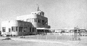
The terminal building, finished in 1939 had 24" thick, steel-reinforced concrete walls that were built to be "bomb proof".
By 1940, Grand Rapids was one of only six American cities boasting scheduled air service in all directions and, because it fulfilled all requirements for night lighting, hundreds of WWII military pilots eventually received their primary & advanced flight & ground school instruction at the field through 1944.
By 1946, the Kent County Airport had total of five asphalt or tar runways, with the longest being the 4,400' southeast/northwest runway and saw the introduction of an Air-Cargo service.
By 1949 the airport's facilities were strained to the maximum,and the citizens of Kent County voted to expand the airport at its current location, and required the purchase of 120 acres & 89 houses to the south. In early 1952 the newly expanded 5,700' runway was completed. For a time, movable gates were necessary to keep 44th Street traffic from crossing the airport's longest runway while planes were taking off & landing. (at the bottom of the picture)

By 1957, the airport again bursting at the seams, and the decision was made to replace the original airport with a new one. In 1961, construction began on what is today Gerald R. Ford International Airport about 7 miles east.
When the airport closed in 1963, it had a 5,700' concrete Runway 18/36, a 4,400 asphalt Runway 12/30, and a 3,400' asphalt Runway 4/22, and airline service was available from Lake Central Airlines, North Central Airlines, and United Airlines.
By the late 60s, the transformation to industrial park was well underway.

By 2005 the airport had been completely redeveloped with industrial buildings, however, many of the runways are still visible today:

#1 - RBC Memorial Drive - formerly Concrete Runway 18/36
#2 - 36th St Boluevard - formerly Runway 09/27
#3 - "Bend" in RBC Memorial Drive - formerly Runway 12/30
#4 - Lousma Drive - formerly Runway 01/19
Please use caution crossing the street to retrieve the cache.