FAROL DA
NAZARÉ
Forte de São Miguel
Arcanjo
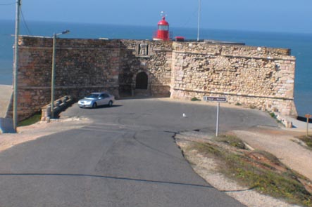
O Forte de São
Miguel Arcanjo, também referido como Forte do Morro da Nazaré,
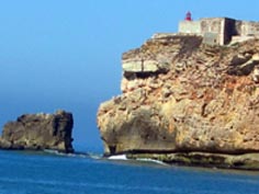
localiza-se na vila da Nazaré, no extremo do promontório, a mais de
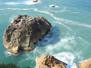
80 metros de altura. Frente a ele encontra-se a Pedra do
Guilhim, um enorme rochedo batido pelas ondas.
|
|
|
| Forte e Pedra do
Guilhim |
Atenção ao
Mar |
Pedra do
guilhim |
“Da barbacã do Forte, para Sul, a vista alcança horizontes
longínquos e a vila ganha uma nova dimensão; para norte,
descobre-se o vasto areal da Praia do Norte, bela e desconhecida,
rodeada de dunas e pinhais, protegida a sul pelo promontório, que
na sua base esconde uma pequena gruta natural – o Forno d´Orca (ver
cache). A Praia do Norte é um espaço preservado e ecológico,
dedicado pela natureza ao Turismo de Evasão, à pesca desportiva, ao
surf e body-board, aos passeios a pé ou de bicicleta. Poupada da
intervenção humana, a Praia do Norte permite o reencontro da
natureza com o mar e a aventura solitária do descanso merecido.
|
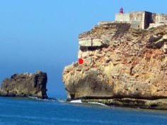
Ao chegar ao Forte
(fechado ao público), desça pelo lado direito da barbacã. Na parte
posterior, vai encontrar umas escadas metálicas que o convidam a
descer e a contemplar de perto a Pedra do Guilhim
Descendo as
escadas e voltando à esquerda vai descobrir um pequeno varandim na
rocha chamado " A carreirinha"(ponto vermelho na foto). Miradouro
excepcional sobre o mar e a praia da Nazaré, este é também um
belíssimo ponto de pesca desportiva (à linha). |
|
"(http://www.nazare.oestedigital.pt)
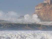
ATENÇÃO:
Olhe primeiro para o mar. Há dias em que não é
possível descer.
Um pouco de História
A primitiva
estrutura remonta ao reinado de D. Sebastião (1557-1578), que ali
determinou erguer uma fortificação para defesa do povoado
piscatório do monte da Pederneira (1577), por cujo porto era
escoada a madeira do Pinhal d’El Rey (Pinhal de Leiria) e cujos
estaleiros já possuíam importância económica de vulto à época.
Essas obras, entretanto, só ganhariam impulso durante a Dinastia
Filipina, quando o rei D. Filipe II (1598-1621), por volta do ano
de 1600, determinou reconstruir a primitiva fortaleza de acordo com
a planta do arquitecto florentino Giovanni Vicenzo Casale.
Necessitando
de reparos no início do século XVII, à época da Guerra de
Restauração da independência portuguesa a Coroa determinou a sua
modernização e ampliação (1644), quando adquiriu a sua actual
conformação.
É um notável
monumento militar maneirista, característico da defesa da costa,
com planta longitudinal irregular adaptada ao promontório sobre o
qual assenta. Possui um baluarte em cada ângulo, grossas muralhas
diversas vezes restauradas, com contrafortes, ameias e frestas,
dispondo de uma original Praça de Armas no 2º piso. Por cima da
porta de entrada, sob um lintel, uma imagem em baixo-relevo de S.
Miguel Arcanjo e a legenda “El-Rey Dom Joam o Quarto – 1644”.
Durante a 1ª Invasão Francesa (Junot – 1807/1808), esteve ocupado
por soldados de Napoleão I, que a população do Sítio e da
Pederneira ajudou a expulsar, tornando-se assim num símbolo da
resistência popular.
Em 1903, foi instalado um farol nas suas dependências, com a função
de auxílio à navegação naquele trecho do litoral.
O Farol da Nazaré,
activo até hoje, com um alcance luminoso de quinze milhas náuticas,
completado por um sinal sonoro de aviso em dias de nevoeiro
intenso.”
Adaptado de :
http://www.nazare.oestedigital.pt) e
http://pt.wikipedia.org/wiki/Forte_de_S%C3%A3o_Miguel_Arcanjo)
THE LIGHTHOUSE OF
NAZARÉ
Fort of São Miguel
Arcanjo
|
|
|
| Fort and
Guilhim's rock |
Look at the
sea! |
Guilhim's
rock |
St. Michael
Archangel's Fort, also related as the Mount of Nazaré's Fort
, is located in the village of Nazaré, at the extremity of the
promontory, at more than 80 meters height.
In front of it stays the Guilhim’s Rock, an enormous Rock beaten by
the waves.
From the barbican of the Fort, to the South, the sight reaches
distant horizons and the village itself gains a new dimension; to
the north, the vast sand area of the North’s Beach, a beautiful
undiscovered dune encircled by pinewoods, protected from the south
by the promontory, that in its base hides a small natural grotto –
O Forno d´Orca ( view cache). The North’s Beach is a preserved and
ecological space, dedicated by nature to the Evasion Tourism,
fishing sports, to surf and body-board, foot and bicycle
strolls.
Saved from the
human intervention, the Beach of the North allows the reunion of
the nature with the sea and the lonely adventure of the deserved
rest.
|
While reaching the
Fort (closed to a public), go down on the right side of the
barbican. At the backside of the fort you’ll find a metal
staircase inviting you to go down and appreciate the
Pedra do Guilhim (Guilhim’s Stone.).
Going down the staircases
and returning on the left you’ll discover a small balcony in the
rock named as "Carreirinha"( the photo's red point ).
Exceptional viewpoint over the sea and Nazaré’s beach, this is also
the most beautiful point of sporting fishing (line fishing).
” |
|
ATTENTION:
Look first at the sea . Some days it is not
possible to go downstairs.
A
little History
“The primitive structure retraces to the reign of D.
Sebastião (1557-1578), that determined to raise there a blockhouse
for defense of the fiching town on the hill of Pederneira (1577),
by whose port was drained the wood of the King’s Pine
tree(Leiria’s Pine tree)and whose shipyards already had economical
importance at the time.
These workmanships, however, would only gain a new impulse during
the Phillipino Dynasty, when the king D. Filipe II (1598-1621),
during the year of 1600, determined to rebuild the primitive
fortress in accordance with the plant of the Florentine architect
Giovanni Vicenzo Casale.
Needing repairs, at the beginning of century XVII, by the time of
the Restoration of Portuguese Independence’s War the Crown
determined its modernization and magnifying (1644), when it
acquired its current conformation.
It is a remarkable mannerist military monument characteristic of
the coast defence, with a longitudinal irregular plant
well-adjusted to the promontory on which it settles. It has a
rampart in each angle, thick walls several times restored, with
counterforts, battlements and gaps, disposing of an original Square
of Arms in the 2nd floor. Over the entrance door, under a lintel,
an image in bas-relief of S. Miguel Arcanjo and the inscription “
El-Rey Dom Joam the Room – 1644 ”.
During the 1st French Invasion (Junot – 1807/1808), it
was occupied by soldiers of Napoleão I, whom the population of the
Sítio and of Pederneira helped to expel, returning so a
symbol of the popular resistance.
In 1903, a lighthouse was installed in his dependences, with the
function of help to the navigation in that passage of the
coast.
The Lighthouse of Nazaré, still working, with a bright
reach of fifteen nautical miles, completed by a resonant sound in
intense thick foggy days”
Adapted from :
http://www.nazare.oestedigital.pt) and
http://pt.wikipedia.org/wiki/Forte_de_S%C3%A3o_Miguel_Arcanjo)
A cache
As coordenadas indicadas são as do
estacionamento do Farol. A cache final encontra-se em N 39º
36.(A) W 9º 04.(B)
Para determinar os pontos A e B
precisam dos seguintes dados
N o lado sul do estacionamento há um
pequeno muro de protecção sobre o precipício. Tem buracos para
escoamento de água rectangulares e circulares. Conte o numero de
buracos rectangulares e circulares.
R= Buracos rectangulares
C= Buracos circulares.
Vá agora pelo lado oposto e contorne
a muralha virada a Norte. Conte quantas janelas vê.
J= Janelas
A fórmula para calcular os pontos A e
B é a seguinte (peço desculpa por esta mania de complicar uma coisa
que até é simples):
A=100+ (R x R) -J + C
B= C x A + C
A cache final está colocada a
cerca de 400 metros do estacionamento, já a caminho do Sítio.
Portanto antes de subir para ir embora aproveite a paisagem,
fotografe e dê uma vista de olhos à carreirinha, se tiver pernas e
o mar o permitir. Muito cuidado! E se ainda não o tiver feiro vá
até ao "Forno de Orca".
Agora sim é tempo de ir à procura do Ponto Zero do “FAROL DA NAZARÉ “ e
faça o log..
É uma caixa de tamanho normal,
embrulhada num saco de plástico preto contendo de início:
stashnote, logbook, lápis, afiadeira e prendas para troca.
English
The Cache
These coordinates
are those of the Lighthouse parking. The final cache is at N 39º
36. (A) W 9º 04. (B)
To determine the A
and B points you’ll need the following data
On the parking
south side there is a small protection wall onto the precipice. It
has rectangular and circular holes for water drainage. Count the
number of rectangular and circular holes.
R = rectangular
Hole
C = circular
Hole.
Go now on the
opposite side and turn the wall by the North face. Count how many
windows you see.
J=Windows
The formula to
calculate the A and B points is as follows (I apologise for this
mania of complicating things that are simple):
A=100+(R x R) -J + C
B = C x A + C
The final cache is
placed about 400 meters far from the parking, on your way out to
Sítio. So, before you leave enjoy the landscape, take pictures and
take a look at “Carreirinha”, if your legs and the sea will permit
it. Take good care of you! And if you hasn’t do it before then go
to the " Forno de Orca ".
Now it’s time to
look for the Zero Point of
“FAROL DA NAZARÉ “
and log. It.
It is a
regular box wrapped in a black plastic bag, and it contains a
logbook, a pencil and a sharpener and some gifts for
exchange.