
 After the massive eruption that formed the Yellowstone Caldera (Yellowstone Caldera at Madison Junction) lava oozed out of cracks in the bottom of the caldera until about 60,000 year aso. The flow at Firehole Falls is approximately 120,000 years old. This lava was rhyolitic in composition. About 30 different individual flows have been identified covering some 1,000 square miles called the Plateau Rhyolite.
Igneous rocks are typically divided up into four types based on the amount of silica they contain. Silica is a common compound found in the earth’s crust. Rhyolite is a volcanic (an igneous rock that formed on the surface of the earth) rock with the most silica content of the igneous rocks (between 68 to 77%) and tends to be the coolest of the igneous rocks (about 900 deg C). It is typically light red to pink to tan and has very few if any visible crystals. Due to their high silica content and relatively low temperature, molten rhyolite is typically thick and chunky (viscous). See USGS for a set of graphics.
Because rhyolite is viscous it usually doesn’t flow very fast or far from where it has erupted. It is estimated that the rhyolite at Firehole River moved as slow as 3 feet per day. Some of the rhyolite flows at Yellowstone are up to 18 miles long, likely because of the volume of lava that was erupted. In places the flows are 1000 feet thick.
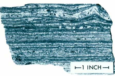 With these slow moving flows, the surfaces would often cool and solidify while the centers continued flowing. Because the surfaces didn’t have a stable foundation, they would crack and break into pieces and form a jumbled surface called a breccia. In the still molten center, tiny layers formed as different minerals grouped together in bands, forming banded rhyolite. These are difficult to see unless you have a good fresh surface. The swimming area a short way up from the falls may have good examples as well.
After the lava cooled, the ancient Firehole River began flowing across the top and over the edge near Madison Junction. Over the thousands of years, the water going over the falls has slowly eroded it way back from the original edge of the flow as well as down into the flow. This type of erosion is called headward erosion.
Logging requirements:
Send me a note with :
- The text "GC15A0J Firehole Falls – Rhyolite Lava Flow" on the first line
- The number of people in your group.
- estimate how far back and down the falls have eroded through the rhyolite flow
- Use your estimates from above to estimate the average rate of erosion of the river
- Look for the breccia and banded flow lines and post a picture if you can find them
The above information was compiled from the following sources:
- Fritz, William J., Roadside Geology of the Yellowstone Country, Mountain Press Publishing Company, May 1989.
- The Geologic Story of Yellowstone National Park, William R. Keefer Illustrated by John R. Stacy, GEOLOGICAL SURVEY BULLETIN 1347 1975 http://www.nps.gov/history/history/online_books/geology/publications/bul/1347/sec3.htm .
Placement approved by the
Yellowstone National Park