FIELD GUIDE TO THE GEOLOGY
ALONG THE OLD KILN TRAIL
Boulder, Colorado
City of Boulder Open Space and Mountain Parks
Sue E. Hirschfeld, Ph.D.
On the Old Kiln Trail you will be walking through geologic time
across older and older rocks. You will see various kinds of
sedimentary rocks, see how these rocks control landforms, see
fossils associated with these rocks, and observe dramatically
changing environments. You can find a detailed
geologic/stratigraphic sequence at
http://ci.boulder.co.us/files/openspace/pdf_education/Boulder_Sediments.pdf.
Print this guide to locate where you are in time and to identify
past environments as you walk along the trail.
To log this EarthCache, please send in an
e-mail two stops which you find particularly interesting.
Briefly describe what you see at these stops that directly
indicates the geology described in this guide.
Upload a photo of at least one person in you party at each of these
two stops, and include in your log the number of people in your
party.
Brief Summary of the Geologic History of the
Front Range.
About 300 million years ago (mya) an earlier mountain range,
called the Ancestral Rocky Mountains, was uplifted.
Sediments eroded from the Ancestral Rockies were deposited by
rivers flowing from the mountains into the sea (Fountain, Lyons).
The Flatirons are formed from these ancient deposits. Over a period
of nearly 200 million years, the Ancestral Rocky Mountains were
worn down, eroded away, and eventually buried under sediments
deposited along the shoreline of the ocean, and in rivers and lakes
(Lykins, Canyon Spring, Morrison, Lykins Formations). At this time,
Boulder (now over 5000 feet elevation) was near sea level. Between
about 100 – 70 mya, ocean water from the Gulf of Mexico and Canada
flooded this area, eventually covered Colorado, and deposited
thousands of feet of sand and mud (Dakota, Benton, Niobrara,
Pierre). Then, beginning around 70 mya, the present (Laramide)
Rocky Mountains were uplifted and the sea retreated. As the
mountains rose, all the previously deposited sedimentary rocks were
tilted up against the rising mountains (creating the
Flatirons and the tilted rocks we see along the Old Kiln Trail –
view geologic cross-section at http://bcn.boulder.co.us/basin/watershed/geology/crosssec.html).
DIRECTIONS TO STOPS AND LOCATIONS OF INTEREST ARE GIVEN IN
ITALICS.
Trail begins from the Four Mile Creek Trailhead off Lee Hill Road,
west of Broadway in North Boulder. The hike is about a mile round
trip with 400 ft elevation gain. It goes up the Dakota Ridge with a
short, moderate climb at the beginning and then follows an old road
uphill.
TRAILHEAD
Note: GPS tour datum is all WGS84
N 40° 03.750'
W 105° 17.340'
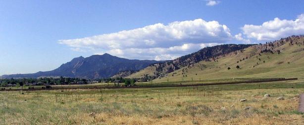
Figure 1. View to the south from the trailhead.
From the trailhead, you can see the contact between two
dramatically different landscapes -- the Great Plains to the east
and the Rocky Mountains to the west. This is a good location to
view the Flatirons, the peaks west of Boulder, and Dakota Ridge on
your right. Remember, the mountains you see today were not here
during the formation of the rocks we see along the trail.
Follow the hiking/biking Foothills Trail south to the Four
Mile Creek crossing.
N 40° 03.699'
W 105° 17.365'
Stop 1. Stream Crossing: note the small size of the stream
as you cross the bridge and the broad, gently sloping area to the
south and west. Keep this in mind at Stop 3.

Figure 2. One of many landslides coming down the east slope of the
Dakota Ridge.
Follow the hiking/biking Foothills Trail south across the
creek to the first trail junction with the Old Kiln Trail. Take the
trail that goes north (right), back toward Lee Hill Road.
N 40° 03.614'
W 105° 17.485'
Stop 2. View south at trail junction: There are many kinds
and generations of landslides on the east slope of Dakota Ridge
(Figure 2). As you follow the Old Kiln Trail uphill, you will get a
close look at the surface of one of these landslides. The highest
part of Dakota Ridge to the west is composed of steeply tilted
sandstones and some shales. The grass covered slopes on the east
side of Dakota Ridge are underlain by the Benton Formation, which
is almost entirely composed of mudstones and shale. The Benton
forms a slippery base for landslides to move down slope.
Continue on the trail north (to the right) to the first
exposure of light-colored shaley rock on your left and the large
boulders near Four Mile Creek on your right.
N 40° 03.779'
W 105° 17.525'
Stop 3. Boulders along Four Mile Creek and the Smoky Hill
Shale: On your right along Four Mile Creek, look at the different
kinds of boulders here and scattered across the surface (fluvial
terrace) between the trail and the houses to the east. There are
examples of different kinds of sedimentary rocks (conglomerate and
sandstone) and a few boulders of granite (1.7 billion years old).
The granite is exposed at least a mile to the west up Four Mile
Canyon. These boulders are rounded, indicating that they have been
carried here by a large flood. The flow of the present creek is not
capable of carrying such large boulders. However, there have been
major climate changes, including glacial episodes in the higher
mountains and periods of higher rainfall, in the last hundred
thousand years,
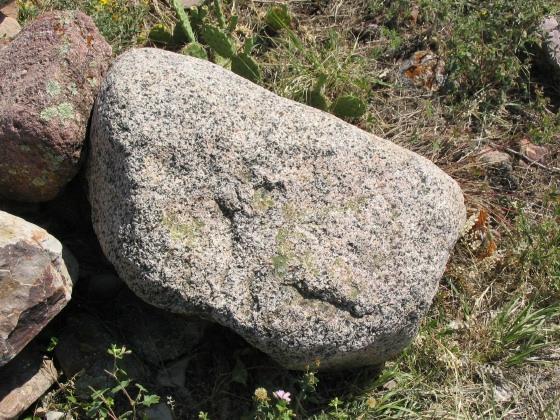
Figure 3. Granite boulder along Four Mile Creek.
The surface that you walked across to get here is the fluvial
(river) terrace of Four Mile Creek. It is underlain by gravel
deposits formed during floods and higher stream flows in the
past.
The rocks exposed on the left side of the trail, to the east,
and up the hill on the Old Kiln Trail were deposited before the
uplift of the present (Laramide) Rocky Mountains. During the
Cretaceous, about 100 to 70 million years ago, Colorado was covered
by a shallow sea that spread from the Arctic Ocean to the Gulf of
Mexico, Through time, the sea rose and fell depositing different
kinds of sediments depending on location of the nearest high land,
where the shoreline was located, water depth, and temperature. We
will see evidence of these changes as we continue along the
trail.

Figure 4. Colorado was covered by a shallow sea during the
Cretaceous.
The first rock unit we will see along the rail is the Upper
Cretaceous Niobrara Formation (formed about 86-82 million years
ago). The Niobrara is divided into two members: Smoky Hill and Fort
Hays. This outcrop is the Smoky Hill Member, the upper part of the
Niobrara Formation. Here the Smoky Hill is a limey shale (Figure
5). An occasional fish scale (bluish-gray color) can be found here
(if you find one, please return if for the next visitor to find).
Shells of clams and oysters are common at other locations along the
Front Range. The Fort Hays (next stop), the lower member of the
Niobrara, will be seen around the corner.
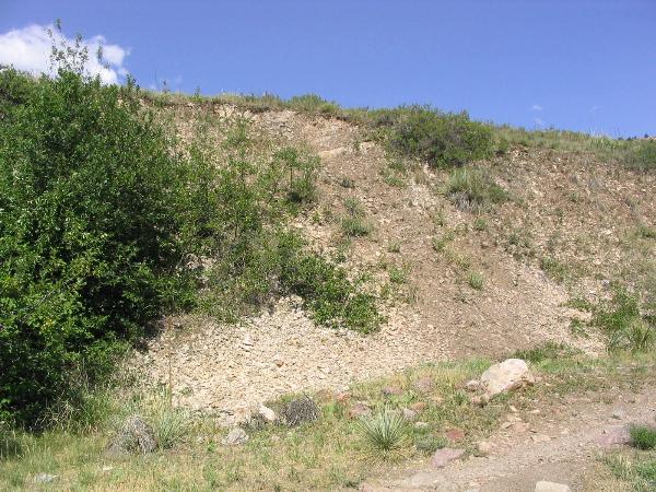
Figure 5. Exposure of Smoky Hill Member of the Niobrara
Formation.
N 40° 03.812'
W 105° 17.630'
Stop 4. Fort Hays Limestone and the old limestone kiln: The
Fort Hays Limestone is tan to light-gray, and can be viewed to the
right of the kiln. Small amounts of shale separate the limestone
beds. The limestone is more resistant to weathering and erosion and
stands out more than the thin, darker and recessed shale. Limestone
is not very common along the mountain front. Most sediment
deposited in the inland sea was mud (clay) and sand. In fact, the
Fort Hays is the most carbonate-rich, mud-poor unit in the entire
Western Interior Seaway2. An explanation for this unusual limestone
occurrence is that this was a time when the shoreline and the
source of the mud and sand was far away. Thus, mud and sand did not
reach this area. Also, warm tropical water moved up from the south,
creating an environment suitable for limestone formation3. The
repetition of beds of limestone alternating with thin layers of
shale has been interpreted to represent climate change resulting
from differences in the orbit of the earth and sun[2].
Limestone (calcium carbonate, CaCO3) is used to produce “lime”
for plaster, mortar, and cement. To produce the lime from
limestone, the rock is heated in the lime kiln to 500-600 degrees
C. This heating drives off the carbon dioxide leaving lime as a
residue. Historically, there were four kilns at Two Mile Creek and
this one (now deteriorated) along Four Mile Creek. This kiln was
probably constructed in the 1880’s. According to Gleichman and
Mutaw, (1998)1, the Four Mile Creek kiln is noted for its crudity
of construction, which led to much wastage due to over or under
burned lime. Lime produced here may have been used in construction
of some of the University of Colorado’s earliest buildings.
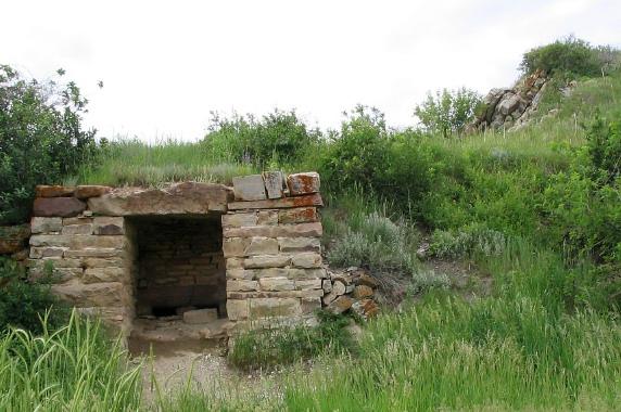
Figure 6. Lime kiln and Fort Hays Limestone (upper right).
Walk past the kiln and uphill to the trail junction and
overlook
N 40° 03.705'
W 105° 17.679'
Stop 5. Old Kiln Trail junction and overlook: This trail
junction is the approximate location of the contact between
Niobrara Formation and older Benton Group (stratigraphically below,
but uphill). The Benton (about 97-89 mya) underlies the
vegetation-covered slope uphill extending to the first sandstone
outcrop (Stop 6). The Benton is composed of mudstones and shales
that are not well exposed along the Front Range. In addition, the
Benton is frequently covered by landslides. The road uphill is
along the side of one of these landslides. Notice boulders of
Dakota sandstone scattered across the surface.
Follow the Old Kiln Trail uphill. The next stops are along a
section of sandstone and shale beds of the Dakota Group. The first
exposure of sandstone is at:
N 40° 03.752'
W 105° 17.796'
Note: The Lower Cretaceous Dakota Group (about 135-97 mya) is a
widespread unit found across the West and Midwest. Along the Front
Range it is subdivided into the South Platte (younger) and Lytle
(older) Formations. The South Platte is further divided into the
Muddy/J Sandstone, Skull Creek Shale, and Plainview Sandstone.
However, these subdivisions are not clearly discernible along the
Old Kiln Trail. For simplicity, they will be described here
primarily by rock type and topographic expression.
The South Platte Formation of the Dakota Group represents the
first Cretaceous marine flooding of Colorado along the Western
Interior Seaway (Figure 4). At times, this part Colorado was at and
below sea level. During deposition of the South Platte Formation,
fluxuations in sea level (or changes in the level of the sea floor)
caused deepening and shallowing of the water (technically,
transgressions and regressions). These environmental changes are
represented in the types of rock formed. Generally, sandstones are
more resistant to erosion than shale/mudstone (that contains large
quantity of clay). Sandstones form topographic ridges, whereas
shales/mudstones form valleys or vegetation covered slopes. Look
north across Lee Hill Road. The two high ridges are mostly
sandstone and the vegetation-covered slope in between is mainly
shale.
The Lytle Formation is the oldest unit of the Dakota Group, is
non-marine, and it formed before the development of the seaway and
flooding of this part of Colorado. The Lytle will be discussed at
Stop 9.
Walk uphill and around the corner to the alternating
sandstone and shale beds pictured below.
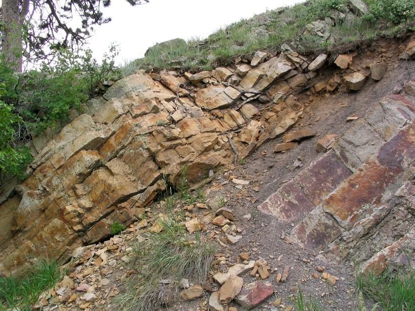
Figure 7. Cross-bedded sandstones and mudstone beds of the upper
part of the Dakota Group (J or Muddy Sandstone).
N 40° 03.753'
W 105° 17.807'
Stop 6. Upper Dakota Group sandstones and mudstones: The
sandstones (and mudstones) at this stop are called the J or Muddy
Sandstone of the South Platte Formation. They are interpreted to
represent a deltaic environment near the inland sea. Deltas are
complex environments (think of the Mississippi Delta today).
Sluggish, meandering rivers with many migrating river channels,
sand bars, floodplains and swamps, tidal channels and nearshore
deposits characterize this environment. At this time, North America
lay closer to the equator so the climate was more tropical. Go to
http://www.dmns.org/main/minisites/ancientDenvers/dakota.html
for a picture of the landscape at this time.
The rocks along the trail are composed of fine-grained,
well-sorted sandstone and mudstone. Look closely at the sandstone
and details of the bedding (orientation of the layers). There are
excellent examples of cross-beds that form where flowing currents
of water have deposited sand at different angles. To see a close-up
example of cross-bedding go to: http://walrus.wr.usgs.gov/seds/bedforms/photo_pages/pic28.html.
The cross-beds in the sandstone along the trail indicate currents
flowing in different directions, interpreted to have formed in a
meandering river or tidal channel.
Walk farther up the trail. Look at the thickening and
thinning of the beds.

Figure 8. Beds in the right half of the picture thicken and thin
representing migrating channels along a river.
These are examples of channels in a meandering river system that
were abandoned and then filled with fine sand. The sand-filled
channels were then covered with silt, making them clearly visible.
Remember, all these rocks were deposited horizonally, and they have
been tilted with the rise of the present Rockies.
Continue farther along the trail to the organic rich
mudstones (Figure 9).
N 40° 03.747'
W 105° 17.825'
Stop 7. Swamp deposits and fossil plant roots: These
organic-rich (black) mudstones (Figure 9) are interpreted to
represent a swamp on the floodplain between the meandering
channels. Roots of the swamp plants are preserved in the sandstone
below the mudstone (Figure 10).
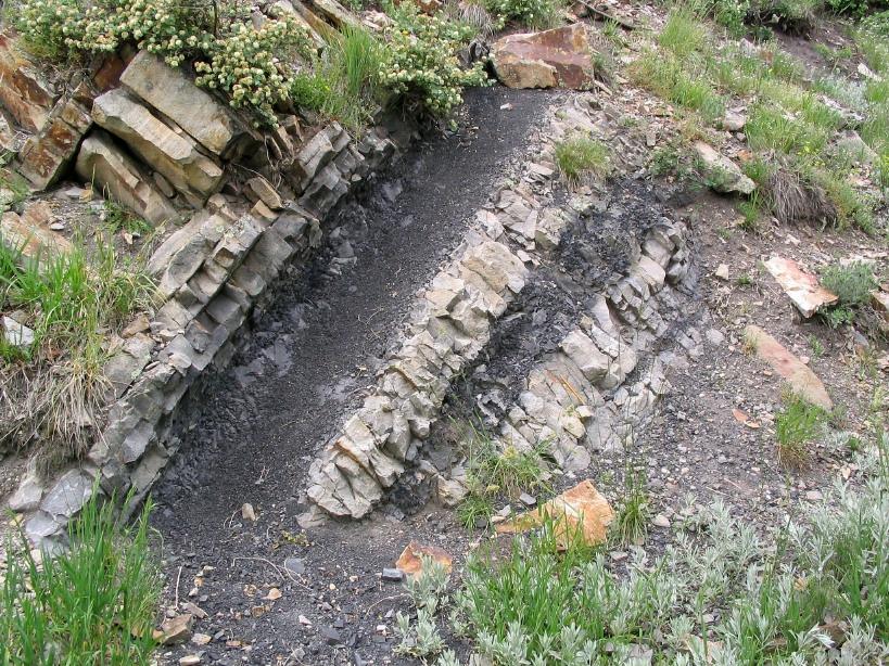
Figure 9. Organic-rich mudstones, representing a swamp, alternating
with sand-filled channels. See detail of roots of swamp plants
preserved in the sandstone below the mudstone (Figure 10).
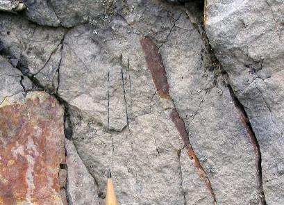
Figure 10. Close-up of sandstone (Figure 9) showing fossil plant
roots (black line at end of pencil) that grew into the sandstone
below the mudstone. Reddish stains are found along fractures to
left and right of roots.
The Upper Dakota Group rocks you have just seen at Stop 6 and 7
continue north across Lee Hill Road and form the high east ridge of
Dakota Ridge.
Continue along the trail. The next stop is an exposure of
sandstone (not prominent).
N 40° 03.743'
W 105° 17.864'
Stop 8. Trace fossils in a marine sandstone: Look for a
small outcrop of sandstone along the trail. Close observation will
reveal a block that contains single and branching tubes (Figure
11). These are trace fossils. These fossils are not the actual
remains (hard parts) of the organisms. Rather, they are evidence of
the activity of marine organisms as they moved through the sediment
in burrows and feeding tubes.
As you look across Lee Hill Road to the north, you can see the
middle units (Skull Creek and Plainview) stratigraphically below
(west of) the Upper Dakota sandstone. They are mostly mudstone and
shale deposited in deep water of the Western Interior Sea far from
shore. They are covered with vegetation and form a valley between
the more resistant sandstone ridges.
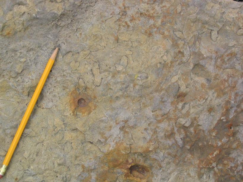
Figure 11. Trace fossils: burrows of marine organisms. Pencil for
scale.
Continue up the trail to the next prominent ridge of
sandstone. Remember, as you hike uphill, you are crossing older and
older units.
N 40° 03.757'
W 105° 17.885'
Stop 9. Lower Dakota Group sandstone, cross-beds and
pebbles: Along the trail at the bend is a sandstone unit
corresponding to the western high ridge (north) across Lee Hill
Road. This sandstone is interpreted to represent the Lytle
Formation, the lowest unit of the Dakota Group.
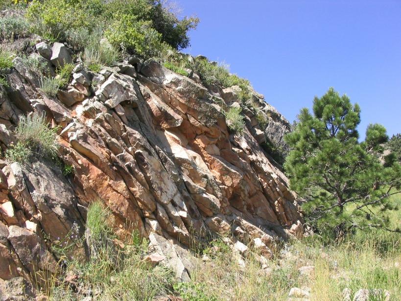
Figure 12. Lower part of the Dakota Group corresponding to the
western prominent ridge across Lee Hill Road.
If you look carefully, you can see where small faults have cut
and polished the sandstone (slickensides). Also, look for many
excellent examples of cross-bedding in the layers.
As you walk uphill toward the west end of the outcrop, notice
the scattered pebbles in the layers of sandstone. The presence of
these pebbles is used to identify the Lytle Formation. In other
sections along Dakota Ridge, the Lytle is characterized by large
concentrations of rounded pebbles and cobbles. Lytle sediments were
deposited by rivers flowing from highlands as far away as
Utah.
An excellent example of cross-bedding can be found in an
isolated block along the trail.
Continue uphill to the next sandstone outcrop.
N 40° 03.751'
W 105° 17.985'
Stop 10. Lakes and rivers: The Upper Jurassic Morrison
Formation (about 155-145 mya) underlies the Dakota Group. Numerous
terrestrial (on land in contrast to marine) environments are
represented in the Morrison including rivers, floodplains, lakes
and marshes. Much of the Morrison consists of multi-colored clays
and soils, often shades of purple, red, and green. The Morrison
Formation is famous for dinosaur fossils and uranium deposits
farther west. Along the Front Range, the Morrison is not
well-exposed and forms vegetation-covered slopes on the west side
of Dakota Ridge. At this stop along the Old Kiln Trail, the gray
sandstone is more resistant to erosion (than adjacent shale) so it
forms a prominent ridge. This sandstone was deposited in migrating
river channels. Observe the beautiful examples of cross-bedding
here.
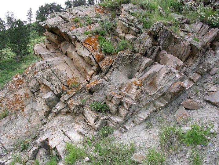
Figure 13. Cross-bedded sandstone in the Morrison
Formation.
Continue up the trail to the limestone illustrated in Figure
14.
N 40° 03.744'
W 105° 18.103'
Stop 11. Morrison Formation limestone. The hard, blue-gray
layers exposed here are limestones (CaCO3) in the Morrison
Formation, interpreted to have formed in a freshwater lake or
marsh.
Figure 14. Limestone in the Morrison Formation.
Continue up the trail. Look for the white sandstone in the
recessed area in figure 15. If you reach the red shale, you have
gone too far.
N 40° 03.745'
W 105° 18.019'
Stop 12. White cross-bedded sandstone: The sandstone at this
stop is the Middle Jurassic Canyon Springs Member of the Sundance
Formation (about165-161 mya), a cross-bedded sand dune deposit. It
does not stand out as a prominent ridge since the sand is not
well-cemented and thus is more easily eroded. A better exposure is
in the road cut on the north side of Lee Hill Road (Figure 16). It
is easy to pick out between the red Lykins Formation below (west)
and the vegetation-covered Morrison Formation above (east).
Figure 15. Canyon Springs Sandstone Member of the Sundance
Formation is the white sandstone along the Old Kiln Trail.
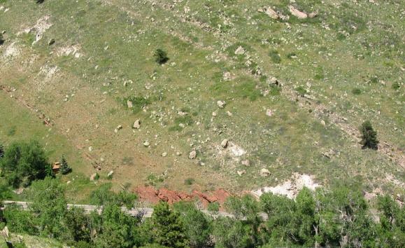
Figure 16. View of Lykins (red mudstones on left) stratigraphically
below the Canyon Springs Member of the Sundance Formation (white)
looking north across Lee Hill Road. The Morrison Formation is the
gray strata on the far right. View is oldest strata on the left to
youngest strata on right side of the picture.
Continue up to the bend in the trail. Look closely at the
strata to find the ripples.
N 40° 03.747'
W 105° 18.038'
Stop 13. Lykins ripples and mudcracks: Along the Old Kiln
Trail and along Ridge Drive (dirt road at end of trail) is the
upper part of the Lykins Formation. It is composed of bright red,
fine-grained sandstone and siltstone. The Lykins Formation ranges
from Permian into the Triassic, at a time when the Ancestral Rocky
Mountains were deeply eroded and a shallow continental sea occupied
this region (during much of geologic time shallow seas flooded the
continent). Look closely at the layering of the strata at the bend
in the trail for the succession of ripple marks (Figure 17). These
ripples record sediment moved back and forth by tidal action.
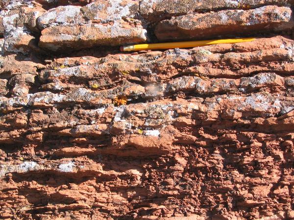
Figure 17. Lykins mudstones showing ripple marks (below
pencil).
At times, the mud flats were exposed to the atmosphere where
they dried and cracked as shown by the mud cracks in the isolated
block on the north side of the trail (Figure 18).

Figure 18. Lykins showing mudcracks (on right side of trail going
uphill). Pencil for scale.
Look to the north. Notice that Lee Hill Road and Old Stage Road
run up a valley. This valley occurs in the Lykins Formation along
the mountain front between Dakota Ridge, and the Lyons Sandstone,
that forms the next ridge to the west. Since the Lykins Formation
is mostly mudstone, it is easily eroded forming a valley.
Continue up the trail onto Ridge Drive (dirt road). Walk past
the building on the left. Look for additional ripples in the
sandstone and shale, especially on the underside of the sandstone
beds.
N 40° 03.695'
W 105° 18.077'
Stop 14. Sole marks: As you walk south along Ridge Drive,
look at the underside of the sandstone layers that are exposed by
erosion. At the bottom of the fine-grained sandstone are features
called sole marks. You will be looking at the bottom of a
layer in the same way you look at the sole on your shoe if you turn
it over. Look for features like the photograph below.
Unfortunately, these don’t show up well in some light. Sole marks
are formed where flowing currents of water sculpt depressions in
the underlying mud. These depressions (often airfoil-shaped) are
then filled with the sand in the layer above. There are several
places along the road where interesting sole marks are formed above
mudstones. Look for good examples of ripple marks also.
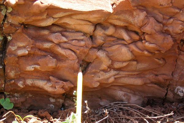
Figure 19. Sole marks indicating scours in underlying mudstone by
current carrying and depositing sand.
As you walk along Ridge Drive, notice the direction and
orientation (strike and dip) of the Lykins strata. It is going to
change abruptly. See if you can find this location.
N 40° 03.659'
W 105° 18.109'
Stop 15. Fault zone: A fault is break in the rock where the
two sides have moved relative to one another. As you walked up Old
Kiln Trail and along Ridge Drive, the Lykins strata tilt (dip) to
the east. Notice the sudden change in the tilt (to the south) and
orientation the strata (dip and strike). This is due to
faulting.
Continue a short way farther south along Ridge Drive to the
location illustrated below (Figure 20).
N 40° 03.645'
W 105° 18.121'
Stop 16. Fault clearly exposed: Note the numerous small
offsets in the strata by the change in composition, color, and
thickness of the layers. There are also small folds and kinks at
the south end of the exposure.
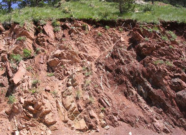
Figure 20. Fault zone with numerous offsets between sandstone and
shale.
This fault extends across the Lykins Valley through the quarry
to the northwest. You can see a change in direction of the strata
in the light-colored Lyons Sandstone marking the fault.
This is the conclusion of the field guide. Return down the
Old Kiln Trail to the trailhead. You will be walking forward in
time as you go downhill. When you reach the trail junction, you can
take the trail to the right (not as steep) or to the left (the way
you came) to return to the parking area.
References Cited:
1. Gleichman, Peter J. and Robert Mutaw, 1998, Cultural Resources
of City of Boulder Open Space: Mt. Sanitas and Related Parcels,
Native Cultural Services.
2. Locklair, Robert and Sageman, Bradley, 2006, Evaluation of
tectonic and oceanographic forcing factors on the formation of
exceptionally carbonate-rich hemipelagic facies, Cretaceous Western
Interior Basin, GSA Abstracts and Programs, Vol. 38, No.7, p.
388.
3. Longman, Mark W., Barbara A. Luneau, and Susan M. Landon, 1998,
Nature and distribution of Niobrara Lithologies in the Cretaceous
Western Interior Seaway of the Rocky Mountain Region, The Mountain
Geologist, Vol. 35, No. 4, p 137-170.
Additional Resources:
Bridge, Raymond, 2004, The Geology of Boulder County, Lone
Eagle Publications, Boulder, CO., 468 p.
Matthews, Vincent, Katie KellerLynn, and Betty fox, 2003,
Messages in Stone, Colorado Geological Survey, 157 p.