Opolenec Traditional Geocache
-
Difficulty:
-

-
Terrain:
-
Size:  (small)
Please note Use of geocaching.com services is subject to the terms and conditions
in our disclaimer.
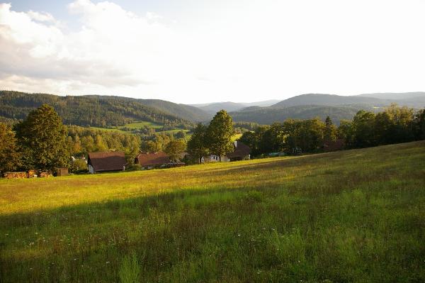
[CZ] Cache s vyhledy na vrcholky Sumavy se nachazi v blizkosti obce Opolenec.
[EN] This cache with some nice views of Sumava is located near to the village Opolenec.
[DE] Dieser Cache mit schönen Ausblicken nach Böhmerwald findet sich in der Nähe von Oppelitz (Opolenec).
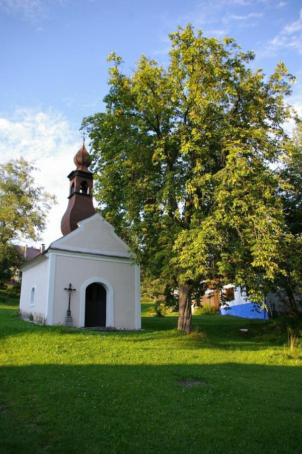
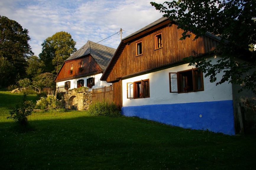
[CZ] Doklady o existenci Opolence sahaji do 15. stoleti, je vsak pravdepodobne, ze se zde jiz ve 14. stoleti usadili delnici pracujici na stavbe blizkeho hradu Kasperk. Az do Druhe svetove valky zde zilo nemecky mluvici obyvatelstvo. Za komunismu okoli Opolence slouzilo k obcasnym vojenskym cvicenim, lesni zakopy a betonove ukryty pro tanky jsou patrne dodnes (nad obci Tuškov se ovsem nachazi i lehka betonova opevneni - "řopíky" - z 30. let 20. stoleti). Od 70. let 20. stoleti slouzi Opolenec prevazne jako rekreacni oblast. Za pozornost stoji kaplicka uprostred navsi a okolni puvodni obytna staveni.
K cache se autem nejlepe dostanete od obce Tuskov, muzete ho zaparkovat nad Tuskovem (waypoint PARK1) a pote pokracovat zapadne po ceste k palouku na kraji lesa (waypoint GLADE1). K cache je to pak uz opravdu blizko, muzete vyuzit bud pesinku v lese ci se projit po loukach nad Opolencem.
Dalsi varianty cesty do Opolence jsou:
1) od autobusove zastavky Radesov po louce a pak doleva nahoru po lucni pesince (cca 1km) - pouze pesky!
2) odbocit doleva ze silnice vedouci ze Susice do Kasperskych hor cca 500m za odbockou na Annin (zde zaparkovat) a pote pesky nahoru do kopce cca 1km.
3) po ceste vedouci ze stredu Tuskova (kolem popelnic s trideninym odpadem) a potom 1,5km stale dal.
Hodne stesti a peknych zazitku pri hledani cache!
[EN] Although the written evidence of existence is dated back to the 15. century, it is probable, that first inhabitans of Opolenec were workers helping with the erection of the near castle Kasperk. Until the Second world war the village was inhabited with german-speaking population. During the communist era, occasional military trainings took place in the surroundings of Opolenec. Some dug-outs and concrete tank shelters can be still found in the woods (a few bunkers from the 1930´s can be found above the Tuskov village though). From the 1970´s Opolenec is mainly used as a recreational area. You should notice the chapel in the center of the village as well as the original houses around.
When travelling by car, the best way is to leave it above Tuskov (waypoint PARK1) and follow the road heading west to a forest glade (waypoint GLADE1). The cache is realy near then, you can either take a walk in meadows above Opolenec or use the path at the forest edge.
Some other ways to Opolenec are:
1) from the bus-stop
in Radesov, use the path in meadow and then turn left and continue up to Opolenec (cca 1km) - by foot only!
2) on the road from Susice to Kasperske Hory, turn left cca 500m after the junction leading to Annin (leave the car there). Then continue by foot up cca 1km to Opolenec.
3) use the road starting in the middle of Tuskov (sorted waste is there) and then continue cca 1,5km.
I wish You good luck and nice time spent with this cache!
[DE] Obwohl die ältesten Nachweise über die Existenz von Oppelitz (Opolenec) aus dem 15. Jahrhunderts kommen, ist es vermutlich, dass die ersten Einwohner sich schon im 14. Jahrhunderts während des Aufbaufs der Burg Karlsberg (Kasperk) an diesem Ort angesiedelt haben. Die deutsche Bevölkerung hat hier bis zum Zweiten Weltkrieg gelebt. Während des Kommunismus sind in der Umgebung gelegentliche Militärübungen stattgefunden - verschiedene Waldsappen und Tankverstecke sind bis heute sichtbar (über Duschowitz (Tuskov) gibt es aber auch ein Paar Betonbunker aus den 30. Jahren des 20. Jahrhunderts). Seit den 70. Jahren ist Oppelitz vor allem ein ruhiges Feriengebiet geworden. Die alte Kapelle im Dorfmitte und die umliegenden Bauernhöfe gehören zu den wichtigsten Sehenswürdigkeiten.
Falls Sie mit dem Auto anreisen wollen, lassen Sie ihn am besten auf dem Waypoint PARK1 über Duschowitz (Tuskov). Dann gehen Sie westlich auf dem Weg nach einer Waldlichtung auf den Koordinaten GLADE1. Jetzt sind Sie schon ziemlich nah! Benutzen Sie jetzt entweder den Waldsteig oder machen Sie einen Spaziergang auf den Wiesen über Oppelitz.
Andere Möglichkeiten sind:
1) von der Bushaltestelle "Schröbersdorf (Radesov)" gehen Sie auf die Wiese, dann den Waldrand entlang, dann nach links und oben fortsetzen. Circa 1,5 Km, nur zu Fuss!
2) etwa 500m nach der Annathaler (Annin) Kreuzung von der Strasse Schüttenhofen-Bergreichenstein abbiegen. Hier parken und circa 1 Km nach oben zu Fuss gehen!
3) der aus dem Mitte Duschowitz (Tuskov) führende Weg benutzen (sortierter Abfall ist da). Dann ist es etwa 1,5 Km.
Viel Glück und schöne Stunde beim Cache suchen!
Additional Hints
(Decrypt)
[CZ] cbq iryxlz xnzrarz
[EN] haqre ovt fgbar
[DE] hagre rvarz tebffra Fgrva