Inglés:
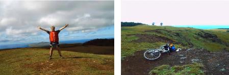
Mount Terevaka is a non active volcano situated in the most northern part of the island and formed one of the three biggest cones which constructed the surface of the island. This irregular cone covers almost the major part of the island and with the hight of 511 meters above sea level it is also the highest point of the Easter Island. It’s the youngest of the three most important volcanos having their origin due to a process of eruptions started about 12.000 years ago. The last eruptions happened more or less 10.000 years ago and Mount Terevaka was formed together with the actual triangle named “Easter Island” From the top you will have a great view over the whole island.
Log permission: To find this cache you first have to look for a date on a plaque at S 27° 08.408 W 109°25.509 and sent the answer by email together with the answers of the next questions:
-What are the names and the height of the other two volcanos?
-Spread over the whole island you can find a lot of “conos parasitos” What is the explanation of this term?
-Locate and describe a parasitic cone from the posted coordinates, and give its bearing from where you are standing (S, W, E, etc).
Español:
Maunga Terevaka es un volcán inactivo ubicado en el extremo Norte de Isla de Pascua y que forma uno de los tres grandes conos que constituyen la superficie de la Isla. Tiene la forma de un cono irregular que ocupa la mayor parte de la Isla y una altura de 511 metros sobre el nivel del mar siendo su cumbre el punto más alto de Rapa Nui. Es el más joven de los tres volcanes principales, teniendo su origen en un proceso eruptivo acaecido hace unos 12 mil años aproximadamente. Su último flujo de lava fue hace unos 10 mil años. Según estos datos, la actividad volcánica que dio origen al Maunga Terevaka terminó de formar el triángulo que es hoy Isla de Pascua. Desde su cumbre se puede apreciar toda la Isla y una visión panorámica circular del horizonte.
Para hacer un log válido hay que buscar una fecha en un cartel a S 27° 08.408 W 109°25.509 y mandamela por email juntos con las respuestas de las seguientes preguntas:
-Como se llaman los dos otros vulcanos principales.
-La isla está cubrido de un montón de “conos parasitos” Qué significa esta expresíon?
-Localiza y describe cualquiera cono parásito y dame su dirección desde las coordenadas puesta (S, O, E)

From the guidelines: "People do not need to wait for permission to log your EarthCache. Requiring someone to wait is not supported by the EarthCache guidelines. People should send their logging task answers to you, then log your EarthCache. When you review their logging task answers, if there is a problem, you should contact them to resolve it. If there is no problem, then their log simply stands."