Knivskjellodden is the on the isle Magerøya in Norway. It is the
northernmost point of continental europe and from ther you have a
lokk to the North Cape wiche rises 307 m steep out of the Barents
Sea. The North Cape is a example for a steep coast.
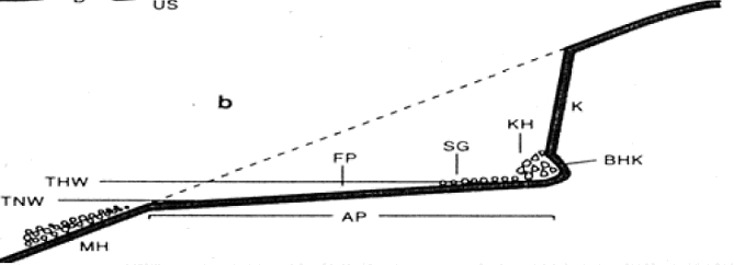
Seen from the geomorpgological perspective the forming of a
steep coast is a result of a continuous erosion of the sea and so
the steep coast belongs to the litoral system. The waves are the
most important geomorphological powers which are responsible for
the erosion. The surge zone is area where the waves break. The
surge self are the broken waves which hit the landmasses. The
abrasion is defined as the erosion of the coast caused by the
surge. In fig. 1 you can see a dashed line. This is the original
surface of the landmasses. But in the course of time the sea erodes
the landmasses to a steep coast.
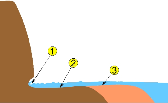
But let’s investigate this process with fig. 2. The
platform of abrasion (2) is called "Schorre" and here the waves are
running against the landmasses. The waves break and the surge
begins to fom an undercut (1). Now there is a overhang and it is
only a question of time when the material of the overhang collapses
because of the weight. How fast this process proceed depends on the
strenght of the surge, the heights of the cliff an the power of the
surge.
From Knivskjellodden you have a very good look to the
northernmost cliff coast and you can observe the powers which are
responsible for the cliff development. Don’t forget your
binoculars. To get the approval for your log, you have to to a
little bit. You can reach this point only by foot. From the road
E69 there is a path to Knivskjellodden that is about 18 km long
(turn-return).
At the end of the path there is a memorial from the local
rambling club (called DNT). Please take a picture of you and your
GPS at this memorial. You can also find a logbook from this
rambling club and please log there an take a picture while you are
logging. Task: If you look to the North Cape you can see the globe
on top of it. How many distinctive trenches do you see in the rocks
from this point direct under the globe? Please send the answer to stefan@midnattsola.com and
please log after getting the permission.
 |
|
Figure 1
|
 |
|
On the way up to the whole
|