Torghatten is a mountain near Brønnøysund at the norwegian
coast. From the sea it is a significant landmark because there is i
big whole in it. But how could such a big whole be formed?
The coordinates are from the parking place. From there a path
goes up to the Torghatten
Up to now the following explanation was usual. Because of the
big ice shield of the ice ages the landmasses were about 100 m
lower than they are today. On this level the surf could erode the
whole into the mountain. After the ice shield melted the weight was
gone and the landmasses could rise. So the whole is on the level
from today. But meantime the doctrine changed. 20.000 years ago the
ice shield reached the continental shelf. With the following warm
period the ice retracted and 12.000 years ago there was no ice at
all on and around the Torghatten.
 |
 |
|
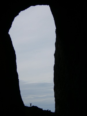
Looking to the Atlantic |
Scale: 1.70 m high person in the
whole |
Sea level was about 100 m above the level from today. The
exfoliation of the granite shows vertical structures and this
brings the physical and chemical weathering especially in the
ceiling forward. Sidewards the weathering is not so intense. And
these are the dimensions of the whole: length 116 m, height 41 m
and width 18m. The ceiling and the sides consist of granite. The
biggest blocks which result from weathering you can find at eastern
an the western end of the whole. 60 m from the western exit there
is knoll in the middle of the whole. This knoll is about 115 m
above the sea level from today. Probably the sea could not erode
the next 100 m the eastern exit.
The "temperature" of a glacier is very important for shaping a
surface. You have to distinguish between warm and cold glaciers. At
the bottom of a warm glacier the pressure is so high that the ice
melts and the glacier flows plastic. Pieces of rock are carried
along at the bottom and these pieces cause scratches on the rocks.
If you have a warm glacier you can also find very strong melt water
streams which can generate kettle basins. "Cold" glaciers have no
melt water and therefore they are not so good in eroding.
 |
 |
|
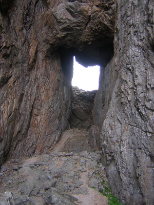
On the way up to the whole |
The whole itself |
The ice shield on and around the Torghatten was a "warm"
glacier. So you can expect glacier scratches and kettle basins. On
the eastern side of the Torghatten you can find such glacier
scratches on the rocks (40 and 100 m above sea level). You can also
find these marks at the sides of the whole and on the knoll.
Furthermore there two kettle basins with a diameter of 2-3 m near
the whole. The scratches and the kettle basins indicate that
glacial processes are responsible for the whole in the Torghatten.
The influense of the Atlantic in the west with his waves to
little.
But now to the tasks which must be solved for the approval of
the log.
1) Take a picture of you standing in the hole of
the Torghatten with your GPS. It is evidence that you have been
there an did not solve the questions from your living-room.
2) Based on the directions of scratch marks give me
the directions, the glaciers was moving (if you want, you can lay
your compass on a stone with the scratch marks and take a
picture).
3) Explain the process of physical weathering.
4) Name one example of a warm glacier and one of a
cold glacier. 5) Thesis: a 2.000 m thick ice shield is on the
surface of the earth. The weight is so great that earth's crust
begins to sink. After the ice age the glacier melts and the weight
is gone. With a delay earth's crust begins to rise. Even now the
land masses of North America and Scandinavia are still rising. What
is the technial term of these phenomena?
So please first send a mail to torghatten_cache@yahoo.no and
after that you get the approval for the caches. Every logs not
approved will be deleted immediately.