Jilovsky zamek - Jilove Castle Traditional Geocache
Jilovsky zamek - Jilove Castle
-
Difficulty:
-

-
Terrain:
-

Size:  (micro)
Please note Use of geocaching.com services is subject to the terms and conditions
in our disclaimer.
Mesto Jilove
se rozklada na rozhrani Decinske vrchoviny a Ceskeho stredohori
v nadmorske vysce 276 m n. m.
Zahrnuje nekolik casti -
Jilove, Kamenna, Martineves, Modra, Kamenec (obec Modra s casti
Kamenec pripojena v roce 1980), Sneznik (obec pripojena v roce
1976).
Od roku 1964 je Jilové mestem. 1. 1. 2004 melo vcetne uvedenych
cástí 5 305 obyvatel.
Mestem proteka Jilovsky potok. Prameni v oblasti Naklerovskeho
prusmyku, v nadmorske vysce 713 m n. m. V prubehu sveho toku sbira
vody nekolika dalsich potoku, napr. Cerveneho, Hornojilovskeho,
Martinevskeho. Po 20 km se v Decine vleva do Labe.
Nad mestem se vypina stolova hora Decinsky Sneznik (723 m n. m.),
nejvyssi bod Decinske vrchoviny. V roce 1864 zde byla postavena 33
m vysoka rozhledna, ktera poskytuje nadherny rozhled do
okoli.
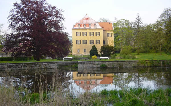
Cache je plastikova krabicka ukryta v zameckem parku
Vice informaci o meste a zamku si muzete
precist
zde
Kes byla nedavno vykradena, proto, prosim,
nevkladejte TB, GC ani jine cenne veci. Davejte velky pozor co se
deje za Vami a za plotem
The Jilove Town
is situated on the boundary of the highland called Decinska
vrchovina and the Bohemian Central Highlands (Ceske stredohori),
its centre lying at an elevation of 276 m a. s. l.
It incorporates several local parts -
Jilove, Kamenna, Martineves, Modra, Kamenec and Sneznik.
Since 1964 Jilove is a town, with 5 300 inhabitants (end of
2004).
Through the town runs the brook Jilovsky potok, rising from the
pass Naklerovsky prusmyk an elevation of 713 m a.s.l. In the course
of its stream it collects the waters of several minor brooks, e.g.
from Cerveny potok, Hornojilovsky potok, Martinevsky potok, and
after 20km joins the river Elbe (Labe) in Decin.
Above the town looms the table mountain Vysoky (Decinsky) Sneznik
(723m a.s.l.), the highest point of the highland Decinska
vrchovina. In 1864 a 33m high look-out tower, offering a gorgeous
view was built on its top.
The Cache is a plastic box and it is hidden in the park near of
the Castle.
More information about the Town and the
Castle You can read
here
Cache was spoilt not long ago, so please
don´t insert TB, GC or any valuable things. Be very aware, what is
happening behind Your back and near fence
Additional Hints
(Decrypt)
[CZ] - Zlfyvz, mr wfrz gnql arwilffv n fgbwvz an cbxynqh
[EN] - V guvax, V nz gur uvturfg urer naq V fgnaq ba gur gernfher