Nature foot trail Macocha /
Naucná stezka Macocha


(CZ) Naucná stezka
Macocha
V blízkosti uvedených souradnic najdete pomník jednoho z významných
krasových badatelu a vchod do Punkevních jeskyní, spolu s propastí
Macocha asi nejznámejšího cíle turistu. Vaším cílem je ale centrum
Moravského krasu,
jehož krasové jevy jsou tvoreny predevším devonskými vápenci,
podrobneji prozkoumat. Asi 6 km dlouhá trasa tvorí uzavrený okruh
vedený prevážne po stezce Jana Šmardy (znacená naucná stezka
Macocha). Trasa vychází z parkovište (N 49°21.805 E 016°42.531
– auto placeno 50,- Kc bez omezení doby) a pokracuje kolem Skalního
mlýna na rozcestí (N 49°21.812 E 016°42.596). Pokracujete pak
vpravo po silnici ke Katerinské
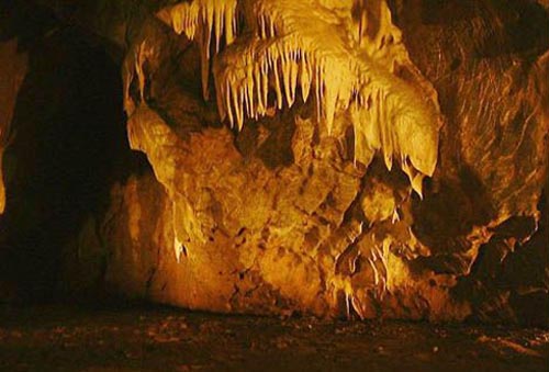
jeskyni. Tato jeskyne je na zacátku Suchého žlebu, asi 500
metru východne od Skalního mlýna. Je soucástí staré výtokové
jeskyne, o cemž svedcí nápadné stopy po proudících vodách a jejich
erozní cinnosti. Katerinská jeskyne byla též bohatým nalezištem
kostí pleistocénních zvírat, predevším medvedu (další informace
najdete na informacní tabuli u jeskyne, do jeskyne se platí vstupné
60Kc, doba prohlídky 30 minut, informace o provozní
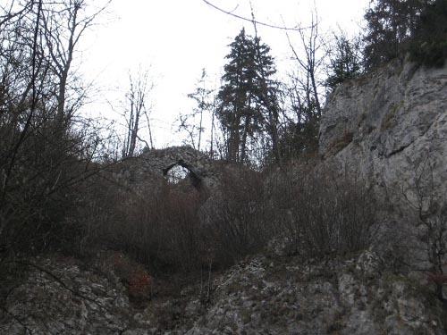
dobe a ceník vstupného). Cesta pokracuje nahoru k vyhlídce
Stena zapadajícího slunce a pres Krenkuv památník prechází kolem
Korálového závrtu k propasti Macocha.
Propast Macocha je nejvetší propastí svého druhu ve strední Evrope.
Propast je hluboká 137,4m, horní cást propasti je dlouhá 174 m a
široká 76 metru. Na okraji propasti jsou dva vyhlídkové mustky
(horní mustek N 49°22.390 E 016°43.769). Propast Macocha vznikla
zrícením stropu velké jeskyne, proto její dno cástecne pokrývá sut
ze zbytku zborceného stropu. Dnem propasti protéká rícka Punkva,
která napájí dve jezírka a vzniká soutokem celé rady ponorných
zdrojnic. Historie pruzkumu zacíná již v roce 1723. Pruzkumy
vyvrcholily roku 1914 zprístupnením suché cásti Punkevních jeskyní
(víc informací na informacní tabuli - N 49°22.360 E 016°43.768).
Cestu si mužete prodloužit k vyhlídce na Konském spádu (N 49°22.731
E 016°43.778), kde se žleb prudce zahlubuje do vápencu a nabývá
charakteru divokého kanonu se svislými skalními stenami. K
vyrovnání výškového spádu 120m vytvárí rícní tok radu velkých
zákrutu, které prodlužují vzdálenost a zmenšují tak spád. Zde je
nejvetší meandr, jehož amfiteátr tvorí 100m vysoká skalní stena
(podrobnosti najdete na stanovišti c. 8 stezky). Po sestupu do
údolí Pustého žlebu minete cestou na stanovišti c.9 zajímavý útvar,
kolem nehož pujdete dále ke vchodu do Punkevních
jeskyní, dva kilometry od Skalního Mlýna. Komplex jeskyní
predstavuje nekolik desítek kilometru jeskyní, z cásti protékaných
podzemními vodami (další informace najdete na informacní tabuli na
stanovišti c.10, do jeskyne se platí vstupné 80 / 100 / 150Kc, dle
délky prohlídky, doba základní prohlídky 60 minut, informace
o provozní
dobe a ceník vstupného). Nakonec vede cesta po asfaltové ceste
zpet ke Skalnímu mlýnu. Na ceste najdete ješte další tri zajímavá
stanovište.
Pro zalogování cache není nutná placená návšteva jeskyní,
musíte ale splnit podmínky:
1. Poslat mi na email svoje foto s GPS u Krenkova památníku
(samostatným lovcum stací foto jejich GPSky a památníku).
2. Poslat mi na email svoje foto s GPS u pametní desky na Spodním
mustku (samostatným lovcum stací opet foto jejich GPSky a pametní
desky).
3. Poslat mi na email jaká skála je na stanovišti c.9, jak se
jmenuje a kde potom uvidíte neco podobného (nápoveda - je to hned
poblíž následujícího stanovište)?
4. Jak se jmenuje jeskyne u stanovište c.12 a jaká je její délka?
Je možné v oblasti potkat kunku obecnou (lat. Bombina bombina -
nápovedu hledej na stanovišti c.13)?
V souladu s pravidly budou smazány logy, nesplnující uvedené
podmínky.

(EN) Nature foot trail Macocha
You will find the monument of J. Wankel and
the entry to Punkva Cave near of the coordinates of this cache. But
our goal is a detailed exploration of the centre of the
Moravian
Karst, formed especially from devonian limestones.
Nature foot path
Macocha begins in the northern part of the Moravian Karst at
Skalní Mlýn (The Rock Mill). We will go from the parking area (N
49°21.805 E 016°42.531 - charge is 50,-CZK/about 2USD for a car)
right on the road to the Katerinská jeskyne (Catherine
Cave).
This cave is at the beginning of the Suchý zleb (The Dry Valley).
It is about 500m east of Skalní Mlýn (The Rock Mill). This cave is
also part of a prehistorical outgoing water cave. Traces of a water
stream are very apparent on its walls,creating erosion holes. This
cave had many pleistocene animals, mostly bears. More information
is on the information sign along the Nature foot trail. Katerinská
jeskyne (Catherine cave) is open to the public (admission 60,-CZK /
about 2,5 USD, for more information visit opening hours and
fees).
From here the trail goes up to the Stena Vycházejícího Slunce
stand (The Cliff of the Rising Sun) and over the Krenkuv památník
(Krenkuv Monument) and the Korálový závrt (The Coral Sink hole) to
the famous Macocha
Abyss. The Macocha Abyss is the biggest gorge of its kind
(light hole type) in Central Europe. It´s more than 137,4m deep.
The upper part of this natural wonder is about 174 m long and 76 m
wide. There are two plateaus for tourists at the edges. The first
one is the Upper Bridge, the second one is the Lower Bridge. The
bottom of Macocha is made by a debris cone and there are also two
small lakes called Horní (Upper) and Spodní (Lower). Lazar
Schopper, the monk of a minor monastery became the first known
person to descend into Macocha in the year 1723 (you will find more
information on the information sign along the Nature foot trail).
The next steps of this foot trail lead you to view point called
Konský spád (The Horse Drop - N 49° 22.731 E 016° 43.778).
There is a deep valley that is about 100m at the view Konský spád
/ The Horse Drop (you will find more information on the information
table on stage No. 8 of the Nature foot trail). After you descend
to the Desert Valley you will seen interesting rock on stage No. 9
of the Nature foot trail. If you go to the next stage, No. 10,
there is an entry to Punkvevní
jeskyne (Punkva Cave) from there. The cave is one of only 4
caves which is open to the public (admission 80,-/100,-/150,-CZK /
about 3 / 4 / 6USD, for more information visit opening hours and
fees). There is an underground river, which is mostly very
deep, about 40 m.
There you can see the bottom of the Macocha
(Macocha Abyss) in 137,4 m depth, too. You have arrived at the
Skalní Mlýn (The Rock Mill). From there, you will find the next
three interesting stages of the Nature foot trail
too.
You must fulfill the requirements to log
this cache (payment visit of the caves is not needed):
1. Send me an email with a picture of yourself, your GPSr and
Krenkuv památník (Krenkuv Monument - the independent hunter -
upload a picture of your GPSr and the monument only).
2. Send me an email with a picture of yourself, your GPSr and
memorial tablet in plateaus for tourists at the Lower Bridge.
3. Send me an email - what is on stage No. 9 of the Nature foot
trail, there you will find some similar rock, (hint - it´s nearest
the stage No. 10 of Nature Foot Trail)?
4. What is the name and length of cave on stage No. 12 of Nature
foot trail? Are there live animals named Bombina bombina (lat. -
hint is on the stage No. 13 of Nature Foot Trail)?
The logs which will not comply with the requirements will be
deleted.