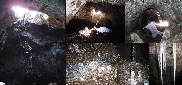
Cueva del Hielo
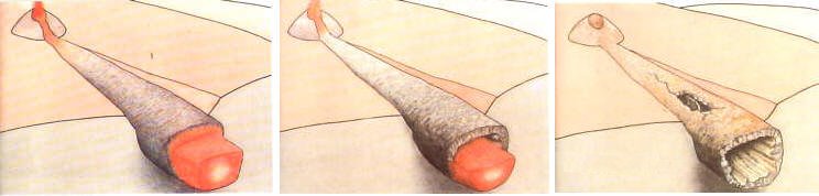
Formation of a lava tube cave
Many areas of extensive volcanic activity are associated with lava tube cave formation. There are two main ways these are formed, the first is a vertical shaft created where lava originally poured out. These shafts though they can be deep rarely extend to any degree laterally. The other type of cave is the result of a lava flow cooling and solidifying on the outside but the inside continuing to flow till the tube empties to some degree. The ideal type of lava for this to occur in is the fluid "pahoehoe lava", this gives rise to many beautiful formations such as uniform channels, levees, stalactites, stalagmites, lava ropes, perfect tubes and smooth floors for walking. The more viscous "Aa lava" is also often encountered in these caves that is generally much rougher and can result in a very uneven floor to the cave. Apart from the primary lava formations we also encounter some fine secondary features, usually stalactites and stalagmites of limonite or silica.
Cueva del Hielo
In "Cueva del Hielo" you will find one of such a lava tube cave. The cave is a result of the eruption of the Teide, the highest mountain of Spain on the Canary Islands . The last eruption of this Stratovolcano took place in 1909. Summer- and wintertime you will find snow and ice in the cave. In former times the "Neveros" carried the ice with mules to La Orotava. There they produced ice cream from it or used it to cure sick people with fever.
There are two posibilities to get to the cave:
-
Use the cable car. The Teleférico Teide goes from the roadside at 2356 m most of the way to the summit, reaching 3555 m. From here follow the way down from Teide to N 28° 16.457 W 16° 37.985 (ca. 3405 m). A very small path leads to N 28°16.480 W 16° 37.987. It will take you about 1 hour.
-
Leave the Canadas Road near Mirador de Tabonal Negro (see little map) and climb up the way to Teide, pass Montana Blanca and Refugio de Altavista. It will take you about 3 hours. From the position N 28° 16.457 W 16° 37.985 (ca. 3405 m) a very small path leads to N 28°16.480 W 16° 37.987.

Remember:
- Especially in summer have enough water with you.
- Respect nature and don´t leave the path.
To log this cache you need to do the following two things:
- This cave differs from other lava tubes. How can the cave have originated. Mail us your opinion.
- Optional: Log with a picture (at the entry or underground
 ).
).
Have a lot of fun and be careful,
road_runner & susi
|
You can also log at
|
 |
last update 13.9.2009