German: Die Fränkische Schweiz ist ein einzigartiger Naturraum im Norden Bayerns. Ihren Namen hat sie aus der Romantik aufgrund ihrer besonderen Steinformationen und malerischen Landschaften.
Die Fränkische Schweiz mit ihrer typischen Landschaft ist zur Zeit des Jura vor gut 140 Millionen Jahren enstanden, als sich unter tropischen Bedingungen ein starkes Riffwachstum vollzog. Am Ende des Jura wurde das Riffgebiet rund um die Teufelshöhle angehoben und in dem nun zu Festland gewordenem Gebiet setzte die Höhlenbildung ein. Steter Tropfen formt den Stein - zumindest bei Tropfsteinen. Das durch feinste Ritzen und Klüfte in den Fels eindringende Wasser löst Calcium und Magnesiumkarbonat und baut es an anderer Stelle wieder auf: Von der Decke hängend, als Stalaktiten, oder vom Boden aufsteigend, als Stalagmiten. Aber das Ganze geht sehr langsam: 13 Jahre vergehen, bis ein Tropfstein einen Millimeter gewachsen ist. Etwa 1000 Höhlen wurden in der Frankischen Schweiz endeckt und erschlossen.
Mehr Informationen zum Thema Fränkische Schweiz und geführte Touren findet Ihr auf
Geopark Bayern-Böhmen
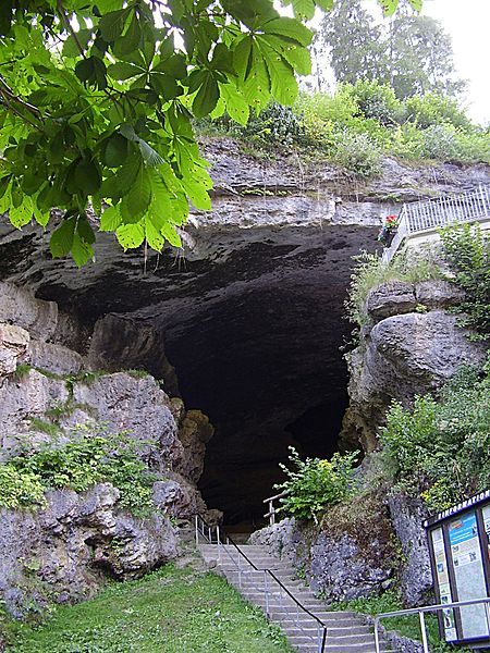
Bei den Koordinaten befindet sich die „Teufelshöhle“, welche für diesen Naturraum besonders charakteristisch ist. Um den Cache zu loggen, könnt ihr ein Foto von euch vor einem typischen natürlichen Merkmal der Fränkischen Schweiz machen aber müsst folgende Fragen beantworten:
1) Welche Gesteinsart bzw. welche Landschaftsform ist für diesen Naturraum typisch?
Antwort1 = __ __ __ __ __ oder __ __ __ __ __ __ __ __ __ __ __ __ __ __ (2 verschieden Antworten wären o.k)
2) In der Höhle (im „Kleinen Teufelsloch“) befindet sich eine Forschungseinrichtung. Was wir dort in Langzeitmessungen untersucht?
Antwort2 = __ __ __ __ __ __ __ __ __ __ __ __ __ __ __ __ __ __ __ __
schickt nun eine E_mail an : earthcache@posteo.org
Beispiel: wäre die Antwort1 "Geo", Antwort2 "Cache" wäre die E-mail: geo-cache@gmx.de
Das Foto könnt Ihr nach Logfreigabe online stellen.Ihr erhaltet unmittelbar eine E-Mail, wenn die Antwort richtig ist. Wenn Ihr für mehrere die Freigabe einholt, dann bitte die Namen in die Betreffzeile mit einfügen!
In der Nähe der Höhle könnt Ihr alle Antworten finden. Dafür müsst Ihr nicht in die Höhle, es gibt einen Weg, der um sie herum führt. Dennoch lohnt sich der Besuch! Parken könnt Ihr an obigen Koordinaten, die Preise sind sehr fair. Auch lohnt es sich vorher Pottenstein anzusehen und von dort hierher zu wandern (ca. 1,5 km). Ihr werdet eine wundervolle Landschaft erleben.
English:
The Franconian Switzerland
The Franconian Switzerland is a unique region in the north of Bavaria. It got its name from the romantic period because of its special rock formations und beautiful landscape.
The Franconian Switzerland with its typical landscape has been formed about 140 million years in the past during the jura period. Under tropical conditions riffs were able to grow. In the end of this period the land had been lifted and caves were formed by water finding its way into the rock formations, taking calcium and magnesium carbonat and placing it somewhere else. That's how stalagmites (growing upwards) and stalactites (growing downwards) grow. But it takes quite a long time: 13 years for a single milimeter. Nearly 1000 caves have been found and explored in the Frankonian Switzerland.
You’ll find the “Devil’s Cave” at the coordinates, which is very typical for this region. To be able to log the cache you have to take a picture of yourself in front of a typical natural characteristic of the Franconian Switzerland and answer these questions:
1) Which type of rock or landscape formation is typical for the Franconian Switzerland?
2) There is a scientific facility inside of the cave (in the “small devil’s hole”). The scientists are doing a long term measurement there. Please tell me, what they examine (beside drinking coffee).
Answer both questions by mailing me! After my o.k. you can log and add your picture if you want
You can find all the answers near the cave. You don’t need to go inside, there is a way leading around the cave. But it is worth a visit! You can find a parking place at the coordinates where they charge fair fees but you can also park in the town Pottenstein and hike to the cave (ca. 1,5 km). The landscape is magnificent!