|
Tato multicache Vás zavede asi tri kilometry západním smerem od obce Maríz na místo zvané Trojmezí (Dreiländerstein), kde se setkávají hranice Cech, Moravy a Rakouska. Je zde historický hranicní trojhranný kámen a nedaleko nej nekolik hranicních kamenu, které vytycovaly panství rakouského (puvodne spanelského) slechtického rodu Hoyos (výbezek Rakouska do Cech s názvem Bohmische Sass).
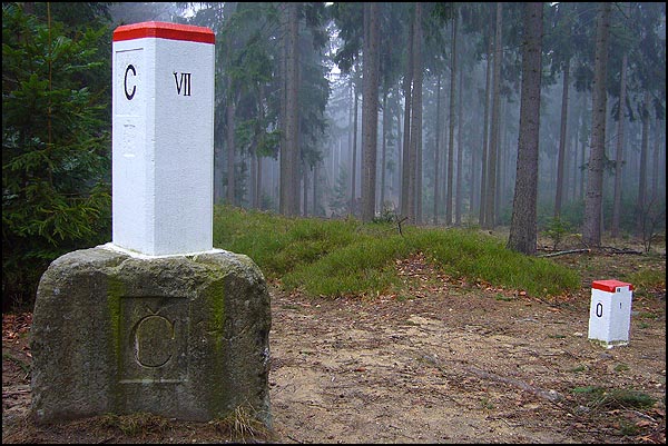
Výchozím bodem pro hledání cache jsou souradnice N49° 00.334' E15° 17.291'. Zde naleznete hranicní kámen oznacující hranici mezi Cechami a Moravou. Na podstavci kamene je vygravírován letopocet ve tvaru ABBC.
Pokracujte na N49° 00.246' E15° 17.039', kde muzete v prípade, ze jedete autem zaparkovat - dál jiz muzete jen po svých, ci na kole...
Po pekné lesní ceste se vydáte ke státní hranici, kde na souradnicích N48° 59.565' E15° 17.365' naleznete jiz zmínený hranicní kámen. Na jednom z jeho boku je cerne vyznaceno datum ve tvaru DE.F.DGHI (kde F musíte prevést z rímských císlic do nasich, tj. arabských...).
A nyní vám ji z nic nebrání nalézt cache na souradnicích N48° 59.JFA' E15° 17.LKC', kde J=F-A, K=F+D a L=E/H.
A short multicache offers interesting visit of one important geographical point, so called Trojmezí (Dreiländerstein). This landmark (or boundary stone) in the shape of triangular prism marks borders among Bohemia, Moravia and Austria.
The starting waypoint is at coordinates N49° 00.334' E15° 17.291'. Here you will find another landmark - in this case between Bohemia and Moravia only, with year ABBC engraved on its basement.
Go to the next waypoint at coordinates N49° 00.246' E15° 17.039'. Here you can park car, because the following part of the forest road is accessible only for pedestrians or bikers.
...nice road leads through the woods directly to the above mentioned Dreiländerstein landmark at N48° 59.565' E15° 17.365'. On the one side of this stone read the date (black on white) in shape DE.F.DGHI (where F in Roman numeral has to be converted into our "Arabic" numeral...).
Now you are prepared for the last task - the final cache hunt at N48° 59.JFA' E15° 17.LKC', where J=F-A, K=F+D and L=E/H.
|