Hopkinton Lookout Traditional Geocache
Ether Bunny: Cache has had its run. Twice muggled recently. Making room for other caches to be placed.
-
Difficulty:
-

-
Terrain:
-

Size:  (regular)
Please note Use of geocaching.com services is subject to the terms and conditions
in our disclaimer.
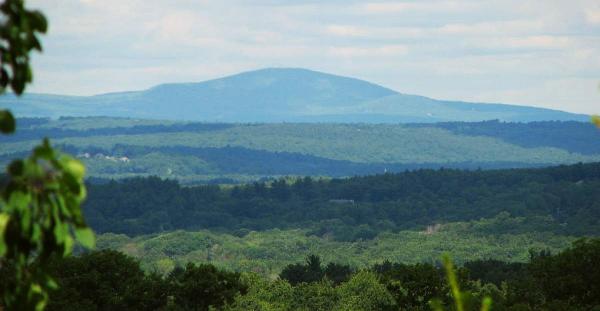
This cache will provide a view of Mt Wachusett, 24 miles north.
Traditional cache on open space land near a nice lookout in
Hopkinton. Cache is not far off a Hopkinton Area Land Trust (HALT)
trail which starts on Greenwood Road. PARK AT THE PROVIDED PARKING
AREA. Room for 2 or 3 cars. Total hike is 1 mile round trip. Take
it from me, the best approach to this cache is as outlined here.
FOLLOW THE WAYPOINTS AS LISTED BELOW FOR EASIEST HIKE. Bushwhacking
is NOT recommended since the terrain can be steep and
slippery.
From parking, cachers can either walk behind several houses on
marked trail which starts at the posted trailhead, or walk up the
street and use the poorly marked ALTERNATIVE TRAILHEAD. The main
trailhead is just 80 feet up the road from parking. Steep at first,
the trail levels off behind several houses. Whether taking trail
behind the houses or walking up the street, head to WAYPOINT 1,
then next to WAYPOINT 2. Make a right at WAYPOINT 2 to follow
unmarked deer trail up to the Lookout. At Lookout, enjoy the view!
Wachusett Mountain is 24 miles away at about 330 degrees magnetic.
Cache is a small ammo can, and is hidden away from most trail
traffic east of the Lookout. Please rehide with plenty of sticks
and leaves.
The trail has been dedicated to Douglas B. Sands (8/7/1915 -
6/22/2001), a lifetime Hopkinton resident and noted
ornithologist.
WINTER SUGGESTION: WALK UP GREENWOOD TO ALTERNATE TRAILHEAD LISTED
TO AVOID ICY CLIMB BEHIND THE HOUSES.
Additional Hints
(Decrypt)
Hfr gur jnlcbvagf tvira, naq nibvq qvssvphyg pyvzo!
Vs vg'f n pyrne qnl, oevat n pnzren!